


Open in App
Get this trail on your phone instantly.

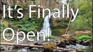
This 12 mile trail runs along and crosses on rustic log bridges or fords many creeks. It offers views of spectactular waterfalls including Horseshoe Falls. At the start of the trail it p asses the ruins of Hickman 's Cabin built in the 1930's and used as a base camp for fire prevention workers. The Siouxon Trail connects with Huffman Peak Trail #129, Horseshoe Ridge Trail # 140, Chinook Creek Trail #130A and Wildcat Trail # 156.
From the first access point on below the first switchback on Forest Road 5701, the trail parallels the road and passes the ruins of Hickman's Cabin. This moss-covered shelter, built in the 1930s, served as a base camp for fire prevention workers. Continuing, the trail intersects Huffman Peak Trail #129, 0.8 mile from the trailhead. Three creeks are crossed before the trail comes to the second access point, near the end of Forest Road 5701 and the second access point to Siouxon Trail. From here the trail drops steeply to West Creek, where a log bridge spans the stream. Following Siouxon Creek to Horseshoe Creek, you can view Horseshoe Falls from the bridge or take the short 0.1 mile spur trail to get a view of the falls from below. The main trail then follows Siouxon Creek upstream for 1 mile, offering views of five major waterfalls and their plunge-pools. After intersecting Horseshoe Ridge Trail #140, the trail continues to the confluence of Siouxon and Wildcat Creeks. Here Wildcat Creek Trail #156 heads north towards Siouxon Peak. A short distance from the junction, the trail intersects Chinook Creek Trail #130A. The trail then gains 1900 ft. in elevation in the final 3 miles before ending on Forest Road 58.
From Amboy, WA continue north on State Route 503 for about 4 miles. In Chelatchie, WA pass Mt. St. Helens National Volcanic Monument Headquarters on your left then turn right on NE Healy Road/Forest Road 54. Continue on Forest Road 54 for about 9 miles and take a left on Forest Road 57. Drive roughly 1 mile to the gravel pit on the right hand side of the road, take a sharp left onto Forest Road 5701. There are two access points on Forest Road 5701 for the Siouxon Trail. The first access point at mile marker 1 at the hairpin corner in the road is intended for horse trailers (park on the pullout on outer edge of corner); the second access point, Siouxon Trailhead, is roughly another 3 miles at the end of the narrow, rough, mostly paved road and does not accommodate horse trailers.
Note: River crossings can be dangerous in spring and early summer!
| c1 | c2 | c3 | c4 |
|---|---|---|---|
January | February | March | April |
May | June | July | August |
September | October | November | December |

Service Road Atlas is a free to use, community-driven service for viewing and creating reports on the numerous back-country service roads around B.C. and Alberta.
Save the current map location and zoom level as your default home location whenever this page is loaded.
SaveWe hope you've been enjoying Trailforks!
Create a FREE account to view trail comments and much more.
You must enter a description before submitting.

