more stats
2,999 ft
Distance
-386 ft
Descent
00:06:53
Avg time
-386 ft
Altitude change
785 ft
Altitude min
1,171 ft
Altitude max
1,171 ft
Altitude start
784 ft
Altitude end
-12.9%
Grade
-28.9%
Grade max
23 ft
Distance climb
2,844 ft
Distance down
131 ft
Distance flat
00:06:53
Avg time

Six Flags Details

  • Activities
    • Mountain Bike
    • Hike
    • Trail Running
    • Snowshoe
  • Riding Area
    Perry Hill
    Waterbury, Vermont
  • Difficulty Rating
  • Local Popularity
    85 in Mountain Biking [+]
    • 80 in Trail Running
    • 65 in Hiking
    • 5 in Snowshoeing
  • Global Ranking
    #19072 in Mountain Biking [+]
    • #60802 in Trail Running
    • #124833 in Hiking
    • #1731 in Snowshoeing
  • Trail Type
    Singletrack
  • Bike Type
    DH, AM
  • Direction
    Downhill Only
    Popular Direction Shown
  • Dogs Allowed
    Yes
  • TTFs on Trail
    Berm, Drop, Rock Face

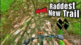
A slab-tastic technical trail with sizable features.

As of Fall 2021, Six Flags has been extended up to the top of Joe's — The new upper section descends an open, flowy spine of rock through the woods, featuring one serious roll as well as some freeride-style berms and jumps. About halfway down, Six Flags rejoins its old route with more technical flow, punchy ups and the Dragon, the longest rock roll in the network. Ride-arounds exist for the bigger features.

Local Trail Association
Traditionally Indigenous Territory

Recent Activity on Trail

Past Week
  • 18 rides
  • 8 miles average
6 Months
  • 36 rides
  • 8 miles avg distance
All
  • 759 rides
  • Last: Jun 17, 2026
c1c2c3c4
January
February
March
April
May
June
July
August
September
October
November
December
update trails status or condition

Six Flags Trail Reports

statusdatedescription
Jun 18, 2026 @ 4:10pm (America/New_York)
1 day
reporter Hard rains today please give time to dry
Jun 18, 2026 @ 4:09pm (America/New_York)
1 day
reporter Hard rains trails will need time to dry out
Jun 16, 2026 @ 11:54am (America/New_York)
Jun 16, 2026
reporter Now open, but please ride carefully if it’s your first time down for the year given the recently completed work and refreshed features.
May 11, 2026 @ 8:29am (America/New_York)
May 11, 2026
reporter Still closed as our trail crew completes some drainage work at the bottom of the 2nd rock roll.
Nov 2, 2025 @ 10:18am (America/New_York)
Nov 2, 2025
reporter Perry Hill is closed for hunting season! Thanks for the awesome season y’all! See you for fat biking in December! ❄️❄️❄️
more »
Status:
on Jun 18, 2026
Variable
Avg: 4.72 (18 votes)
Your vote: 0

view (4,371)
close
3D
Trail Conditions
  • Unknown
  • Snow Groomed
  • Snow Packed
  • Snow Covered
  • Snow Cover Partial
  • Freeze/thaw Cycle
  • Icy
  • Prevalent Mud
  • Wet
  • Variable
  • Ideal
  • Dry
  • Very Dry
Trail Flow (Ridden Direction)
Trailforks scans users ridelogs to determine the most popular direction each trail is ridden. A good flowing trail network will have most trails flowing in a single direction according to their intension.
The colour categories are based on what percentage of riders are riding a trail in its intended direction.
  • > 96%
  • > 90%
  • > 80%
  • > 70%
  • > 50%
  • < 50%
  • bi-directional trail
  • no data
Trail Last Ridden
Trailforks scans ridelogs to determine the last time a trail was ridden.
  • < 2 days
  • < 1 week
  • < 2 weeks
  • < 1 month
  • < 6 months
  • > 6 months
Trail Ridden Direction
The intended direction a trail should be ridden.
  • Downhill Only
  • Downhill Primary
  • Both Directions
  • Uphill Primary
  • Uphill Only
  • One Direction
Contribute Details
Colors indicate trail is missing specified detail.
  • Description
  • Photos
  • Description & Photos
  • Videos
Trail Popularity ?
Trailforks scans ridelogs to determine which trails are ridden the most in the last 9 months. Trails are compared with nearby trails in the same city region with a possible 25 colour shades. Think of this as a heatmap, more rides = more kinetic energy = warmer colors.
  • most popular
  • popular
  • less popular
  • not popular
ATV/ORV/OHV Filter
Max Vehicle Width
inches
US Cell Coverage
Legend
cell carrier legend

Radar Time
Activity Recordings
Trailforks uses anonymized public activity data. ?
Activity Recordings
Trailforks uses anonymized public activity data. ?
Personal Heatmap
Activity Types
all / none
Options
2
Date range month
Winter Trails
Warning A routing network for winter maps does not exist. Selecting trails using the winter trails layer has been disabled.
Missing Trails
Most Popular
Least Popular
Trails are colored based on popularity. The more popular a trail is, the more red. Less popular trails trend towards green.
Jump Magnitude Heatmap
Heatmap of where riders jump on trails. Zoom in to see individual jumps, click circles to view jump details.
BC Backroad Status

Service Road Atlas is a free to use, community-driven service for viewing and creating reports on the numerous back-country service roads around B.C. and Alberta.

map legend
Slope Aspect
Direction the slope faces
Flat N NE E SE S SW W NW
Trails Deemphasized
Trails are shown in grey.
disable
Only show trails with no bike usage.
Enable
Suggested Layers
Based on selected activity type

    Save the current map location and zoom level as your default home location whenever this page is loaded.

    Save
        Directions to six-flags-251702 trailhead (44.334130, -72.726110)

        Photos

        9 more »
        244 |
        Oct 20, 2024 @ 7:28pm
        Oct 20, 2024
        190 |
        Oct 20, 2024 @ 7:28pm
        Oct 20, 2024
        185 |
        Oct 20, 2024 @ 7:28pm
        Oct 20, 2024
        186 |
        Sep 19, 2024 @ 8:45am
        Sep 19, 2024

        Videos

        3 more »
        A VERMONT AMUSEMENT PARK  (SIX FLAGS - PERRY HILL)
        3:03 | 120 | Sep 25, 2025 , Waterbury
        youtuber Most Unique New Trail in New England |...
        9:19 | 701 | Mar 11, 2024 , Waterbury
        Six flags and the Dragon at Perry Hill
        2:13 | 1057 | Jun 13, 2022 , Waterbury

        Routes with this trail

        3.8 11 miles 2,294 ft 11 Loop
        The best that Perry Hill as to offer. Hit all the classics on this loop.
        3,323 ft 1 Point to Point
        This local favorite is pure old-school tech, with steep rock rolls and tight corners. A new extension...
        14 miles 2,819 ft 23 Loop
        Perry Hill is truly the OG – the defining singletrack network that put Vermont on the map. Perry throws...

        5 Reviews & Comments


        We hope you've been enjoying Trailforks!

        Create a FREE account to view trail comments and much more.

        Frequently Asked Questions About Six Flags

        Where is Six Flags located?
        Six Flags is located in Perry Hill, Waterbury, Vermont, United States. It is part of the Perry Hill trail network. The trailhead is located at coordinates 44.33413, -72.72611.
        How hard is Six Flags?
        Six Flags is rated as Double Black Diamond difficulty. The average grade is 12.9%.
        What is the elevation gain for Six Flags?
        The trail has 386 ft of elevation descent. The elevation ranges from 785 ft to 1,171 ft.
        Is Six Flags a point to point trail?
        Yes, Six Flags is a point to point trail. The direction is Downhill Only. The trail type is singletrack.

        Hit the Trail

        Open in App

        Get this trail on your phone instantly.
        open trail in app

        Download Trail

        Save to wishlist, Garmin & download.
        save the trail

        Find Related Routes

        Find routes and users activities that include this trail.
        find routes for this trail

        You must enter a description before submitting.