more stats
2.7 miles
Distance
25 ft
Climb
-1,135 ft
Descent
00:17:32
Avg time
-1,109 ft
Altitude change
1,413 ft
Altitude min
2,522 ft
Altitude max
2,522 ft
Altitude start
1,414 ft
Altitude end
-7.9%
Grade
-25.2%
Grade max
8.9%
Grade min
833 ft
Distance climb
2 miles
Distance down
951 ft
Distance flat
00:17:32
Avg time

Sixth Sense Details

  • Activities
    • Mountain Bike
    • Horse
    • Hike
    • Trail Running
  • Riding Area
    Yacolt Burn State Forest
    Battle Ground, Washington
  • AKA
    Trail #6
  • Difficulty Rating
  • Voted Difficulty
    Blue (7 votes)
  • Local Popularity
    100 in Mountain Biking [+]
    • 70 in Trail Running
    • 65 in Hiking
    • 100 in Horseback
  • Global Ranking
    #10309 in Mountain Biking [+]
    • #19535 in Trail Running
    • #21898 in Hiking
    • #832 in Horseback
  • Trail Type
    Singletrack
  • Bike Type
    AM
  • Direction
    Downhill Primary
    Popular Direction Shown
  • Trail Visibility
    Always easy to follow
  • Season
    Year Round
  • Dogs Allowed
    Yes
  • eBike Allowed
  • TTFs on Trail
    Berm, Drop, Jump, Gap Jump
  • Ride in Rain
    Yes
  • Year Opened
    2018
  • Land Owner
    Washington State DNR

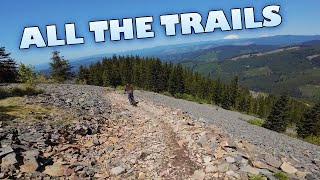
Sixth Sense has a little of everything and provides challenge to all skill levels of riders. It has sections that are moderately rocky and technical as well as some smooth flowy bits. It was designed and built by Evergreen Southwest for the MTB community, but it should be noted that this is a two-way multi-user trail. While it can be ridden at high speed, you need to keep your eyes open for the occasional hiker or horse. On busy days, when the lot is full, it’s also discouraged to pedal up the trail.

Access Info

Park at the main lot and then either climb up Murphy's grade or the 1070 road. It can also be shuttled descending Ross's grade from the Upper Thrillium parking lot.

Disclaimer

CLEAR CUT wiped out the middle 1/3 of this trail. It's been reopened, but it is rough going.

Local Trail Association
Traditionally Indigenous Territory

Recent Activity on Trail

Past Week
  • 6 rides
  • 19 miles average
6 Months
  • 85 rides
  • 11 miles avg distance
All
  • 774 rides
  • Last: Jun 19, 2026
c1c2c3c4
January
February
March
April
May
June
July
August
September
October
November
December
update trails status or condition

Sixth Sense Trail Reports

Status:
on Jun 7, 2026
Ideal
Avg: 4.49 (33 votes)
Your vote: 0

view (4,462)
close
3D
Trail Conditions
  • Unknown
  • Snow Groomed
  • Snow Packed
  • Snow Covered
  • Snow Cover Partial
  • Freeze/thaw Cycle
  • Icy
  • Prevalent Mud
  • Wet
  • Variable
  • Ideal
  • Dry
  • Very Dry
Trail Flow (Ridden Direction)
Trailforks scans users ridelogs to determine the most popular direction each trail is ridden. A good flowing trail network will have most trails flowing in a single direction according to their intension.
The colour categories are based on what percentage of riders are riding a trail in its intended direction.
  • > 96%
  • > 90%
  • > 80%
  • > 70%
  • > 50%
  • < 50%
  • bi-directional trail
  • no data
Trail Last Ridden
Trailforks scans ridelogs to determine the last time a trail was ridden.
  • < 2 days
  • < 1 week
  • < 2 weeks
  • < 1 month
  • < 6 months
  • > 6 months
Trail Ridden Direction
The intended direction a trail should be ridden.
  • Downhill Only
  • Downhill Primary
  • Both Directions
  • Uphill Primary
  • Uphill Only
  • One Direction
Contribute Details
Colors indicate trail is missing specified detail.
  • Description
  • Photos
  • Description & Photos
  • Videos
Trail Popularity ?
Trailforks scans ridelogs to determine which trails are ridden the most in the last 9 months. Trails are compared with nearby trails in the same city region with a possible 25 colour shades. Think of this as a heatmap, more rides = more kinetic energy = warmer colors.
  • most popular
  • popular
  • less popular
  • not popular
ATV/ORV/OHV Filter
Max Vehicle Width
inches
US Cell Coverage
Legend
cell carrier legend

Radar Time
Activity Recordings
Trailforks uses anonymized public activity data. ?
Activity Recordings
Trailforks uses anonymized public activity data. ?
Personal Heatmap
Activity Types
all / none
Options
2
Date range month
Winter Trails
Warning A routing network for winter maps does not exist. Selecting trails using the winter trails layer has been disabled.
Missing Trails
Most Popular
Least Popular
Trails are colored based on popularity. The more popular a trail is, the more red. Less popular trails trend towards green.
Jump Magnitude Heatmap
Heatmap of where riders jump on trails. Zoom in to see individual jumps, click circles to view jump details.
BC Backroad Status

Service Road Atlas is a free to use, community-driven service for viewing and creating reports on the numerous back-country service roads around B.C. and Alberta.

map legend
Slope Aspect
Direction the slope faces
Flat N NE E SE S SW W NW
Trails Deemphasized
Trails are shown in grey.
disable
Only show trails with no bike usage.
Enable
Suggested Layers
Based on selected activity type

    Save the current map location and zoom level as your default home location whenever this page is loaded.

    Save
        Directions to sixth-sense trailhead (45.730350, -122.299060)

        Photos

        70 more »
        98 |
        Sep 10, 2025 @ 5:52pm
        Sep 10, 2025
        149 |
        Jan 23, 2023 @ 10:24am
        Jan 23, 2023
        228 |
        Jun 3, 2022 @ 4:23pm
        Jun 3, 2022
        178 |
        Jun 3, 2022 @ 4:23pm
        Jun 3, 2022

        Videos

        19 more »
        youtuber Yacolt Burn State Forest || Top to Bottom
        52:16 | 175 | Jun 4, 2025 , Battle Ground
        youtuber First impressions of the Propain Hugene 3 CF!
        17:51 | 93 | Oct 20, 2025 , Battle Ground
        youtuber SIXTH SENSE IS OPEN!!
        10:58 | 249 | Apr 21, 2025 , Battle Ground
        youtuber Must Ride Washington Trails! (Cold Creek)
        10:02 | 1757 | Dec 30, 2020 , Battle Ground

        Routes with this trail

        4.0 10 miles 2,339 ft 7
        This is a route that gives you a relatively more approachable road climb up to the towers on the top of...
        10 miles 2,339 ft 7
        This is a route that gives you a relatively more approachable road climb up to the towers on the top of...
        19 miles 4,097 ft 10

        16 Reviews & Comments


        We hope you've been enjoying Trailforks!

        Create a FREE account to view trail comments and much more.

        • By TheBikeNerdTF Pro NWTA & contributors
        • #165371 - 19,193 views

        Frequently Asked Questions About Sixth Sense

        Where is Sixth Sense located?
        Sixth Sense is located in Yacolt Burn State Forest, Battle Ground, Washington, United States. It is part of the Yacolt Burn State Forest trail network. The trailhead is located at coordinates 45.73035, -122.29906.
        How hard is Sixth Sense?
        Sixth Sense is rated as Blue difficulty. The average grade is 7.9%.
        What is the elevation gain for Sixth Sense?
        Sixth Sense has 25 ft of elevation gain. The trail has 1,135 ft of elevation descent. The elevation ranges from 1,413 ft to 2,522 ft.
        Is Sixth Sense a point to point trail?
        Sixth Sense is not a point to point trail. The direction is Downhill Primary. The trail type is singletrack.

        Hit the Trail

        Open in App

        Get this trail on your phone instantly.
        open trail in app

        Download Trail

        Save to wishlist, Garmin & download.
        save the trail

        Find Related Routes

        Find routes and users activities that include this trail.
        find routes for this trail

        You must enter a description before submitting.