more stats
3,365 ft
Distance
478 ft
Climb
-82 ft
Descent
00:19:36
Avg time
396 ft
Altitude change
11,845 ft
Altitude min
12,321 ft
Altitude max
11,903 ft
Altitude start
12,300 ft
Altitude end
11.772%
Grade
-33.542%
Grade max
44.949%
Grade min
2,634 ft
Distance climb
631 ft
Distance down
100 ft
Distance flat
00:19:36
Avg time

Skyline Details

  • Activities
    • Mountain Bike
    • Hike
    • Trail Running
  • Riding Area
    Santa Fe Mountains
    Santa Fe, New Mexico
  • Difficulty Rating
  • Local Popularity
    60 in Mountain Biking [+]
    • 80 in Trail Running
    • 85 in Hiking
  • Global Ranking
    #115304 in Mountain Biking [+]
    • #78205 in Trail Running
    • #56110 in Hiking
  • Trail Type
    Singletrack
  • Bike Type
    XC
  • Direction
    Both Directions
    Popular Direction Shown
  • Climb Difficulty
    Black Diamond
  • Physical Rating
    Hard
  • Dogs Allowed
    Yes

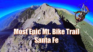
Skyline Trail connects Aspen Vista to the summit of Deception Peak (12,250’). The trail can be ridden as an out and back for the great views or can be linked with the fearsome Raven’s Ridge. From the last switchback on Aspen Vista look for a small singletrack disappearing off into the woods to the north, this is Skyline. Very quickly the trail begins climbing steeply before breaking out above treeline towards the summit. Unless you are a golden god, some of this section will be hike a bike. The trail reaches the summit and technically continues on towards Lake Peak, however this section enters Wilderness (and isn’t even remotely rideable anyway).

Access Info

Multiple Trailheads

Trail Supporters

  • USFS
    Land Manager
Local Trail Association
Traditionally Indigenous Territory

Recent Activity on Trail

Past Week
  • 0 rides
  •  
6 Months
  • 2 rides
  • 21 miles avg distance
All
  • 50 rides
  • Last: Jun 6, 2026
c1c2c3c4
January
February
March
April
May
June
July
August
September
October
November
December
Status:
on Jun 23, 2024
Ideal
Avg: 3.49 (4 votes)
Your vote: 0

view (483)
close
3D
Trail Conditions
  • Unknown
  • Snow Groomed
  • Snow Packed
  • Snow Covered
  • Snow Cover Partial
  • Freeze/thaw Cycle
  • Icy
  • Prevalent Mud
  • Wet
  • Variable
  • Ideal
  • Dry
  • Very Dry
Trail Flow (Ridden Direction)
Trailforks scans users ridelogs to determine the most popular direction each trail is ridden. A good flowing trail network will have most trails flowing in a single direction according to their intension.
The colour categories are based on what percentage of riders are riding a trail in its intended direction.
  • > 96%
  • > 90%
  • > 80%
  • > 70%
  • > 50%
  • < 50%
  • bi-directional trail
  • no data
Trail Last Ridden
Trailforks scans ridelogs to determine the last time a trail was ridden.
  • < 2 days
  • < 1 week
  • < 2 weeks
  • < 1 month
  • < 6 months
  • > 6 months
Trail Ridden Direction
The intended direction a trail should be ridden.
  • Downhill Only
  • Downhill Primary
  • Both Directions
  • Uphill Primary
  • Uphill Only
  • One Direction
Contribute Details
Colors indicate trail is missing specified detail.
  • Description
  • Photos
  • Description & Photos
  • Videos
Trail Popularity ?
Trailforks scans ridelogs to determine which trails are ridden the most in the last 9 months. Trails are compared with nearby trails in the same city region with a possible 25 colour shades. Think of this as a heatmap, more rides = more kinetic energy = warmer colors.
  • most popular
  • popular
  • less popular
  • not popular
ATV/ORV/OHV Filter
Max Vehicle Width
inches
US Cell Coverage
Legend
cell carrier legend

Radar Time
Activity Recordings
Trailforks uses anonymized public activity data. ?
Activity Recordings
Trailforks uses anonymized public activity data. ?
Personal Heatmap
Activity Types
all / none
Options
2
Date range month
Winter Trails
Warning A routing network for winter maps does not exist. Selecting trails using the winter trails layer has been disabled.
Missing Trails
Most Popular
Least Popular
Trails are colored based on popularity. The more popular a trail is, the more red. Less popular trails trend towards green.
Jump Magnitude Heatmap
Heatmap of where riders jump on trails. Zoom in to see individual jumps, click circles to view jump details.
BC Backroad Status

Service Road Atlas is a free to use, community-driven service for viewing and creating reports on the numerous back-country service roads around B.C. and Alberta.

map legend
Slope Aspect
Direction the slope faces
Flat N NE E SE S SW W NW
Trails Deemphasized
Trails are shown in grey.
disable
Only show trails with no bike usage.
Enable
Suggested Layers
Based on selected activity type

    Save the current map location and zoom level as your default home location whenever this page is loaded.

    Save
        Directions to skyline-75200 trailhead (35.788054, -105.781410)

        Photos

        4 more »
        29 |
        Apr 25, 2026 @ 8:52pm
        Apr 25, 2026
        112 |
        Aug 9, 2019 @ 3:40pm
        Aug 9, 2019
        157 |
        Aug 9, 2019 @ 3:40pm
        Aug 9, 2019
        152 |
        Oct 2, 2017 @ 2:56am
        Oct 2, 2017

        Videos

        1 more »
        Most Epic Mountain Bike Trail Santa Fe |...
        16:25 | 262 | Sep 10, 2020 , Santa Fe

        Routes with this trail

        18 miles 3,245 ft 6 Shuttled
        This is the big one. Comparable to big, full, technical days like the Whole Enchilada in Moab, this route...

        1 Review & Comments


        We hope you've been enjoying Trailforks!

        Create a FREE account to view trail comments and much more.

        • By aldousfilcherTF Pro & contributors
        • #75200 - 1,468 views

        Frequently Asked Questions About Skyline

        Where is Skyline located?
        Skyline is located in Santa Fe Mountains, Santa Fe, New Mexico, United States. It is part of the Santa Fe Mountains trail network. The trailhead is located at coordinates 35.78805, -105.78141.
        How hard is Skyline?
        Skyline is rated as Black Diamond difficulty. The physical rating is Hard. The average grade is 11.772%. The climb difficulty is rated Black Diamond.
        What is the elevation gain for Skyline?
        Skyline has 478 ft of elevation gain. The trail has 82 ft of elevation descent. The elevation ranges from 11,845 ft to 12,321 ft.
        Is Skyline a point to point trail?
        Skyline is not a point to point trail. The direction is Both Directions. The trail type is singletrack.

        Hit the Trail

        Open in App

        Get this trail on your phone instantly.
        open trail in app

        Download Trail

        Save to wishlist, Garmin & download.
        save the trail

        Find Related Routes

        Find routes and users activities that include this trail.
        find routes for this trail

        You must enter a description before submitting.