
Open in App
Get this trail on your phone instantly.

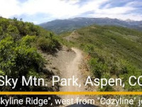
This trail offers some of the biggest & most panoramic views in the upper valley, including 360 degree views at the eastern end near the airport's radar tower structure. The trail roughly follows the ridgeline of Sky Mountain Park, connecting on the west end directly to the Viewline trail, and on the east to Radar Road.
Colorful wildflowers abound along the trail during late spring, early summer, soon after the area opens up to recreation for the season. Views towards Aspen and Snowmass, as well as the high mountains in all directions are incredible. Whether you're a local, or you're visiting the area for the first time, put this trail on your short list
| c1 | c2 | c3 | c4 |
|---|---|---|---|
January | February | March | April |
May | June | July | August |
September | October | November | December |

Service Road Atlas is a free to use, community-driven service for viewing and creating reports on the numerous back-country service roads around B.C. and Alberta.
Save the current map location and zoom level as your default home location whenever this page is loaded.
SaveWe hope you've been enjoying Trailforks!
Create a FREE account to view trail comments and much more.
You must enter a description before submitting.

