more stats
2.3 miles
Distance
237 ft
Climb
-232 ft
Descent
00:23:27
Avg time
3 ft
Altitude change
628 ft
Altitude min
752 ft
Altitude max
628 ft
Altitude start
630 ft
Altitude end
-17%
Grade max
14.9%
Grade min
4,386 ft
Distance climb
3,980 ft
Distance down
3,648 ft
Distance flat
00:23:27
Avg time

Skytop Main Loop Details

  • Activities
    • Mountain Bike
    • Hike
    • Trail Running
  • Riding Area
    Skytop Quarry
    Syracuse, New York
  • Difficulty Rating
  • Local Popularity
    35 in Mountain Biking [+]
    • 5 in Trail Running
    • 5 in Hiking
  • Global Ranking
    #98583 in Mountain Biking [+]
    • #131348 in Trail Running
    • #124336 in Hiking
  • Trail Type
    Singletrack
  • Bike Type
    AM, DJ
  • Climb Difficulty
    Blue
  • Physical Rating
    Hard
  • Season
    Apr-Nov
  • Dogs Allowed
    Yes
  • TTFs on Trail
    Drop, Jump, Pump Track, Rock Face, Skinny
  • Ride in Rain
    Yes

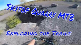
Very technical roller coaster trail with a pump track in the beginning and a jump section plus some skinnies. Outer loop is mainly singletrack with a short pump track section in the middle. Many trails to mix up the ride every time. Trails are just as much fun in either direction.

Access Info

Skytop Rd, NY 13210, trail starts above the parking lot, should see some rubble and stuff leading up to trail head.

This trail is unsanctioned.

Recent Activity on Trail

Past Week
  • 0 rides
  •  
6 Months
  • 1 rides
  • 9 miles avg distance
All
  • 194 rides
  • Last: Mar 10, 2026
c1c2c3c4
January
February
March
April
May
June
July
August
September
October
November
December
update trails status or condition

Skytop Main Loop Trail Reports

statusdatedescription
Aug 30, 2023 @ 11:01am
Aug 30, 2023
Wet in certain spots overgrown in others but all soon to be resolved
Apr 23, 2023 @ 7:41pm
Apr 23, 2023
Muddy conditions as expected after the rain
Aug 14, 2022 @ 7:22am
Aug 14, 2022
Mar 20, 2021 @ 9:38am
Mar 20, 2021
Mar 17, 2021 @ 11:54am
Mar 17, 2021
more »
Status:
on Aug 30, 2023
Variable
Avg: 4.09 (4 votes)
Your vote: 0

view (717)
close
3D
Trail Conditions
  • Unknown
  • Snow Groomed
  • Snow Packed
  • Snow Covered
  • Snow Cover Partial
  • Freeze/thaw Cycle
  • Icy
  • Prevalent Mud
  • Wet
  • Variable
  • Ideal
  • Dry
  • Very Dry
Trail Flow (Ridden Direction)
Trailforks scans users ridelogs to determine the most popular direction each trail is ridden. A good flowing trail network will have most trails flowing in a single direction according to their intension.
The colour categories are based on what percentage of riders are riding a trail in its intended direction.
  • > 96%
  • > 90%
  • > 80%
  • > 70%
  • > 50%
  • < 50%
  • bi-directional trail
  • no data
Trail Last Ridden
Trailforks scans ridelogs to determine the last time a trail was ridden.
  • < 2 days
  • < 1 week
  • < 2 weeks
  • < 1 month
  • < 6 months
  • > 6 months
Trail Ridden Direction
The intended direction a trail should be ridden.
  • Downhill Only
  • Downhill Primary
  • Both Directions
  • Uphill Primary
  • Uphill Only
  • One Direction
Contribute Details
Colors indicate trail is missing specified detail.
  • Description
  • Photos
  • Description & Photos
  • Videos
Trail Popularity ?
Trailforks scans ridelogs to determine which trails are ridden the most in the last 9 months. Trails are compared with nearby trails in the same city region with a possible 25 colour shades. Think of this as a heatmap, more rides = more kinetic energy = warmer colors.
  • most popular
  • popular
  • less popular
  • not popular
ATV/ORV/OHV Filter
Max Vehicle Width
inches
US Cell Coverage
Legend
cell carrier legend

Radar Time
Activity Recordings
Trailforks uses anonymized public activity data. ?
Activity Recordings
Trailforks uses anonymized public activity data. ?
Personal Heatmap
Activity Types
all / none
Options
2
Date range month
Winter Trails
Warning A routing network for winter maps does not exist. Selecting trails using the winter trails layer has been disabled.
Missing Trails
Most Popular
Least Popular
Trails are colored based on popularity. The more popular a trail is, the more red. Less popular trails trend towards green.
Jump Magnitude Heatmap
Heatmap of where riders jump on trails. Zoom in to see individual jumps, click circles to view jump details.
BC Backroad Status

Service Road Atlas is a free to use, community-driven service for viewing and creating reports on the numerous back-country service roads around B.C. and Alberta.

map legend
Slope Aspect
Direction the slope faces
Flat N NE E SE S SW W NW
Trails Deemphasized
Trails are shown in grey.
disable
Only show trails with no bike usage.
Enable
Suggested Layers
Based on selected activity type

    Save the current map location and zoom level as your default home location whenever this page is loaded.

    Save
        Directions to skytop-main-loop trailhead (43.008560, -76.088940)

        Photos

        7 more »
        453 |
        Sep 10, 2022 @ 2:20pm
        Sep 10, 2022
        732 |
        Mar 17, 2021 @ 11:06am
        Mar 17, 2021
        669 |
        Mar 17, 2021 @ 11:06am
        Mar 17, 2021
        639 |
        Mar 17, 2021 @ 11:06am
        Mar 17, 2021

        Videos

        4 more »
        Shredding Skytop Rock Quarry! Syracuse, NY MTB
        14:42 | 1053 | Nov 5, 2020 , Syracuse
        Skytop Quarry Mountain Bike Trails | Syracuse...
        21:31 | 2244 | Oct 26, 2020 , Syracuse
        Gravity Features Skytop Trails
        1924 | Jul 8, 2014 , Syracuse
        The Skytop Schmokers
        0:42 | 252 | Nov 21, 2017 , Syracuse

        Reviews / Comments

        No reviews yet, be the first to write a review or ask a question.
        Use trail reports to comment on trail conditions.


        We hope you've been enjoying Trailforks!

        Create a FREE account to view trail comments and much more.

        • #5807 - 13,120 views

        Frequently Asked Questions About Skytop Main Loop

        Where is Skytop Main Loop located?
        Skytop Main Loop is located in Skytop Quarry, Syracuse, New York, United States. It is part of the Skytop Quarry trail network. The trailhead is located at coordinates 43.00856, -76.08894.
        How hard is Skytop Main Loop?
        Skytop Main Loop is rated as Black Diamond difficulty. The physical rating is Hard. The climb difficulty is rated Blue.
        What is the elevation gain for Skytop Main Loop?
        Skytop Main Loop has 237 ft of elevation gain. The trail has 232 ft of elevation descent. The elevation ranges from 628 ft to 752 ft.
        How long is Skytop Main Loop?
        Skytop Main Loop is 2.3 miles long. The trail type is singletrack.

        Hit the Trail

        Open in App

        Get this trail on your phone instantly.
        open trail in app

        Download Trail

        Save to wishlist, Garmin & download.
        save the trail

        Find Related Routes

        Find routes and users activities that include this trail.
        find routes for this trail

        You must enter a description before submitting.