more stats
5,259 ft
Distance
74 ft
Climb
-805 ft
Descent
00:45:30
Avg time
-732 ft
Altitude change
5,388 ft
Altitude min
6,123 ft
Altitude max
6,120 ft
Altitude start
5,387 ft
Altitude end
-13.9%
Grade
-73%
Grade max
30.8%
Grade min
761 ft
Distance climb
4,144 ft
Distance down
358 ft
Distance flat
00:45:30
Avg time

Slab Paradise Details

  • Activities
    • Hike
    • Mountain Bike
    • E-Bike
    • Trail Running
  • Riding Area
  • Difficulty Rating
  • Voted Difficulty
    Proline (3 votes)
  • Local Popularity
    20 in Mountain Biking [+]
    • 50 in E-Biking
    • 90 in Trail Running
    • 65 in Hiking
  • Global Ranking
    #46939 in Mountain Biking [+]
    • #85724 in E-Biking
    • #19783 in Trail Running
    • #72255 in Hiking
  • Hiking SAC Scale
    T1 Hiking
  • Trail Type
    Singletrack
  • Bike Type
    AM
  • Direction
    Downhill Only
    Popular Direction Shown
  • Climb Difficulty
    Black Diamond
  • Physical Rating
    Hard
  • Trail Visibility
    Always easy to follow
  • Dogs Allowed
    Yes
  • eBike Allowed
    Yes up to Class 1

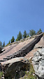
Warning, this a very tech trails, some big slabs to ride, some parts with stairs where you have to push or carry your bike The view is awesome and there is awesome feature to ride but some parts and not very "fun". Push your bike on downhill and more. What the pics and if you do it, be aware !

Recent Activity on Trail

Past Week
  • 0 rides
  •  
6 Months
  • 0 rides
  •  
All
  • 12 rides
  • Last: Sep 4, 2022
c1c2c3c4
January
February
March
April
May
June
July
August
September
October
November
December
update trails status or condition

Slab Paradise Trail Reports

statusdatedescription
Sep 8, 2025 @ 9:15am
Sep 8, 2025
Aug 21, 2025 @ 5:05am
Aug 21, 2025
17.08.2025- Perfect Play Ground. Some up und down!! are to carry the bike. Not for every one. With Trial Skills more fun.
Jun 29, 2025 @ 8:19am
Jun 29, 2025
Hard work indeed, not for everyone
Oct 26, 2022 @ 6:06pm
Oct 26, 2022
more »
Status:
on Sep 8, 2025
Ideal
Avg: 3.99 (2 votes)
Your vote: 0

view (78)
close
3D
Trail Conditions
  • Unknown
  • Snow Groomed
  • Snow Packed
  • Snow Covered
  • Snow Cover Partial
  • Freeze/thaw Cycle
  • Icy
  • Prevalent Mud
  • Wet
  • Variable
  • Ideal
  • Dry
  • Very Dry
Trail Flow (Ridden Direction)
Trailforks scans users ridelogs to determine the most popular direction each trail is ridden. A good flowing trail network will have most trails flowing in a single direction according to their intension.
The colour categories are based on what percentage of riders are riding a trail in its intended direction.
  • > 96%
  • > 90%
  • > 80%
  • > 70%
  • > 50%
  • < 50%
  • bi-directional trail
  • no data
Trail Last Ridden
Trailforks scans ridelogs to determine the last time a trail was ridden.
  • < 2 days
  • < 1 week
  • < 2 weeks
  • < 1 month
  • < 6 months
  • > 6 months
Trail Ridden Direction
The intended direction a trail should be ridden.
  • Downhill Only
  • Downhill Primary
  • Both Directions
  • Uphill Primary
  • Uphill Only
  • One Direction
Contribute Details
Colors indicate trail is missing specified detail.
  • Description
  • Photos
  • Description & Photos
  • Videos
Trail Popularity ?
Trailforks scans ridelogs to determine which trails are ridden the most in the last 9 months. Trails are compared with nearby trails in the same city region with a possible 25 colour shades. Think of this as a heatmap, more rides = more kinetic energy = warmer colors.
  • most popular
  • popular
  • less popular
  • not popular
ATV/ORV/OHV Filter
Max Vehicle Width
inches
US Cell Coverage
Legend
cell carrier legend

Radar Time
Activity Recordings
Trailforks uses anonymized public activity data. ?
Activity Recordings
Trailforks uses anonymized public activity data. ?
Personal Heatmap
Activity Types
all / none
Options
2
Date range month
Winter Trails
Warning A routing network for winter maps does not exist. Selecting trails using the winter trails layer has been disabled.
Missing Trails
Most Popular
Least Popular
Trails are colored based on popularity. The more popular a trail is, the more red. Less popular trails trend towards green.
Jump Magnitude Heatmap
Heatmap of where riders jump on trails. Zoom in to see individual jumps, click circles to view jump details.
BC Backroad Status

Service Road Atlas is a free to use, community-driven service for viewing and creating reports on the numerous back-country service roads around B.C. and Alberta.

map legend
Slope Aspect
Direction the slope faces
Flat N NE E SE S SW W NW
Trails Deemphasized
Trails are shown in grey.
disable
Only show trails with no bike usage.
Enable
Suggested Layers
Based on selected activity type

    Save the current map location and zoom level as your default home location whenever this page is loaded.

    Save
        Directions to slab-paradise trailhead (46.452410, 8.127260)

        Photos

        12 more »
        263 |
        Jul 18, 2022 @ 7:14am
        Jul 18, 2022
        262 |
        Jul 18, 2022 @ 7:14am
        Jul 18, 2022
        265 |
        Jul 18, 2022 @ 7:14am
        Jul 18, 2022
        373 |
        Jul 18, 2022 @ 7:14am
        Jul 18, 2022

        Videos

        1 more »
        0:16 | 562 | Jul 18, 2022 , Fiesch

        2 Reviews & Comments


        We hope you've been enjoying Trailforks!

        Create a FREE account to view trail comments and much more.

        Frequently Asked Questions About Slab Paradise

        Where is Slab Paradise located?
        Slab Paradise is located in Fiesch, Switzerland. It is part of the Fiesch trail network. The trailhead is located at coordinates 46.45241, 8.12726.
        How hard is Slab Paradise?
        Slab Paradise is rated as Proline difficulty. The physical rating is Hard. The average grade is 13.9%. The climb difficulty is rated Black Diamond.
        What is the elevation gain for Slab Paradise?
        Slab Paradise has 74 ft of elevation gain. The trail has 805 ft of elevation descent. The elevation ranges from 5,388 ft to 6,123 ft.
        Is Slab Paradise a point to point trail?
        Yes, Slab Paradise is a point to point trail. The direction is Downhill Only. The trail type is singletrack.

        Hit the Trail

        Open in App

        Get this trail on your phone instantly.
        open trail in app

        Download Trail

        Save to wishlist, Garmin & download.
        save the trail

        Find Related Routes

        Find routes and users activities that include this trail.
        find routes for this trail

        You must enter a description before submitting.