more stats
1,201 ft
Distance
7 ft
Climb
-111 ft
Descent
00:03:00
Avg time
-104 ft
Altitude change
645 ft
Altitude min
756 ft
Altitude max
749 ft
Altitude start
646 ft
Altitude end
-8.7%
Grade
-24.5%
Grade max
11.5%
Grade min
194 ft
Distance climb
932 ft
Distance down
72 ft
Distance flat
00:03:00
Avg time

Slam City Details

  • Activities
    • Mountain Bike
  • Riding Area
  • Difficulty Rating
  • Voted Difficulty
    Advanced (1 vote)
  • Local Popularity
    70 in Mountain Biking
  • Global Ranking
    #50739 in Mountain Biking
  • Trail Type
    Singletrack
  • Direction
    Downhill Only
    Popular Direction Shown
  • Physical Rating
    Moderate
  • Trail Visibility
    Always easy to follow
  • Dogs Allowed
    Yes
  • TTFs on Trail
    Jump
  • Land Owner
    New Plymouth District Council

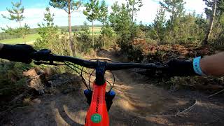
Starts out mellow, before heading into steeper and steeper ground. Lots of big compressions and chunky terrain. Shortened by about a third in Nov 2023 to accommodate a new line for Track the Ripper, which it now merges into.

Trail Supporters
  • NPMTB
    Maintainer
Local Trail Association
Traditionally Indigenous Territory

Recent Activity on Trail

Past Week
  • 1 rides
  • 11 miles average
6 Months
  • 15 rides
  • 12 miles avg distance
All
  • 207 rides
  • Last: Jun 14, 2026
c1c2c3c4
January
February
March
April
May
June
July
August
September
October
November
December
update trails status or condition

Slam City Trail Reports

Status:
on Mar 16, 2023
Ideal
Avg: 4.3 (7 votes)
Your vote: 0

view (2,710)
close
3D
Trail Conditions
  • Unknown
  • Snow Groomed
  • Snow Packed
  • Snow Covered
  • Snow Cover Partial
  • Freeze/thaw Cycle
  • Icy
  • Prevalent Mud
  • Wet
  • Variable
  • Ideal
  • Dry
  • Very Dry
Trail Flow (Ridden Direction)
Trailforks scans users ridelogs to determine the most popular direction each trail is ridden. A good flowing trail network will have most trails flowing in a single direction according to their intension.
The colour categories are based on what percentage of riders are riding a trail in its intended direction.
  • > 96%
  • > 90%
  • > 80%
  • > 70%
  • > 50%
  • < 50%
  • bi-directional trail
  • no data
Trail Last Ridden
Trailforks scans ridelogs to determine the last time a trail was ridden.
  • < 2 days
  • < 1 week
  • < 2 weeks
  • < 1 month
  • < 6 months
  • > 6 months
Trail Ridden Direction
The intended direction a trail should be ridden.
  • Downhill Only
  • Downhill Primary
  • Both Directions
  • Uphill Primary
  • Uphill Only
  • One Direction
Contribute Details
Colors indicate trail is missing specified detail.
  • Description
  • Photos
  • Description & Photos
  • Videos
Trail Popularity ?
Trailforks scans ridelogs to determine which trails are ridden the most in the last 9 months. Trails are compared with nearby trails in the same city region with a possible 25 colour shades. Think of this as a heatmap, more rides = more kinetic energy = warmer colors.
  • most popular
  • popular
  • less popular
  • not popular
ATV/ORV/OHV Filter
Max Vehicle Width
inches
US Cell Coverage
Legend
cell carrier legend

Radar Time
Activity Recordings
Trailforks uses anonymized public activity data. ?
Activity Recordings
Trailforks uses anonymized public activity data. ?
Personal Heatmap
Activity Types
all / none
Options
2
Date range month
Winter Trails
Warning A routing network for winter maps does not exist. Selecting trails using the winter trails layer has been disabled.
Missing Trails
Most Popular
Least Popular
Trails are colored based on popularity. The more popular a trail is, the more red. Less popular trails trend towards green.
Jump Magnitude Heatmap
Heatmap of where riders jump on trails. Zoom in to see individual jumps, click circles to view jump details.
BC Backroad Status

Service Road Atlas is a free to use, community-driven service for viewing and creating reports on the numerous back-country service roads around B.C. and Alberta.

map legend
Slope Aspect
Direction the slope faces
Flat N NE E SE S SW W NW
Trails Deemphasized
Trails are shown in grey.
disable
Only show trails with no bike usage.
Enable
Suggested Layers
Based on selected activity type

    Save the current map location and zoom level as your default home location whenever this page is loaded.

    Save
        Directions to slam-city trailhead (-39.126960, 174.128960)

        Photos

        2 more »
        45 |
        Feb 12, 2018 @ 6:23pm
        Feb 12, 2018
        47 |
        Feb 12, 2018 @ 6:23pm
        Feb 12, 2018

        Videos

        4 more »
        youtuber Slam City @ Lake Mangamahoe Mountain Bike...
        0:31 | 474 | Jan 5, 2021 , New Plymouth
        Slam City - Mangamahoe MTB Park
        0:19 | 162 | Dec 23, 2021 , New Plymouth
        Slam city, Mangamahoe, New Plymouth
        0:21 | 695 | Oct 4, 2019 , New Plymouth
        Slam City - Mangamahoe
        1042 | Nov 13, 2015 , New Plymouth

        Routes with this trail

        5.0 7 miles 971 ft 17 Loop
        A good starter route that will help familiarise you with the sorthern and central areas of the park and...
        4 miles 705 ft 35
        A self made route taking in some of the more xco style trail with 4 main climbs and less flowy decent....
        3 miles 567 ft 17 Loop Race
        Trying to find a good hard XC loop which replicates bigger XCO races. 4 Pretty big climbs and 4 reasonably...

        1 Review & Comments


        We hope you've been enjoying Trailforks!

        Create a FREE account to view trail comments and much more.

        • By ralleyTF Pro & contributors
        • #41712 - 2,367 views

        Frequently Asked Questions About Slam City

        Where is Slam City located?
        Slam City is located in Mangamahoe Mountain Bike Park, New Plymouth, New Zealand. It is part of the Mangamahoe Mountain Bike Park trail network. The trailhead is located at coordinates -39.12696, 174.12896.
        How hard is Slam City?
        Slam City is rated as Advanced difficulty. The physical rating is Moderate. The average grade is 8.7%.
        What is the elevation gain for Slam City?
        Slam City has 7 ft of elevation gain. The trail has 111 ft of elevation descent. The elevation ranges from 645 ft to 756 ft.
        Is Slam City a point to point trail?
        Yes, Slam City is a point to point trail. The direction is Downhill Only. The trail type is singletrack.

        Hit the Trail

        Open in App

        Get this trail on your phone instantly.
        open trail in app

        Download Trail

        Save to wishlist, Garmin & download.
        save the trail

        Find Related Routes

        Find routes and users activities that include this trail.
        find routes for this trail

        You must enter a description before submitting.