more stats
804 ft
Distance
-127 ft
Descent
00:04:47
Avg time
-127 ft
Altitude change
1,080 ft
Altitude min
1,207 ft
Altitude max
1,207 ft
Altitude start
1,079 ft
Altitude end
-15.8%
Grade
-45%
Grade max
-0.9%
Grade min
764 ft
Distance down
00:04:47
Avg time

Sleep Tight Details

  • Activities
    • Mountain Bike
  • Riding Area
  • Difficulty Rating
  • Local Popularity
    95 in Mountain Biking
  • Trail Type
    Singletrack
  • Bike Type
    DH, AM, XC, DJ
  • Direction
    Downhill Only
    Popular In Reverse
  • Climb Difficulty
    Black Diamond
  • Physical Rating
    Hard
  • Trail Visibility
    Sometimes hard to follow
  • Season
    All year
  • Year Opened
    2023

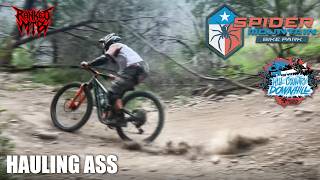
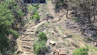
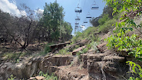
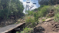
This double black trail beneath the lift line at Spider Mountain is an old pro line that has seen many new developments such as an opening rock drop, high speed long and low jump, as well as the largest drop in the park. This revised version of Sleep Tight officially opened August 27th of 2022.

Bike Park

Recent Activity on Trail

Past Week
  • 1 rides
  • 20 miles average
6 Months
  • 84 rides
  • 18 miles avg distance
All
  • 376 rides
  • Last: Jun 14, 2026
c1c2c3c4
January
February
March
April
May
June
July
August
September
October
November
December
update trails status or condition

Sleep Tight Trail Reports

statusdatedescription
Jun 22, 2025 @ 10:22am
Jun 22, 2025
Apr 13, 2024 @ 1:52am
Apr 13, 2024
Mar 11, 2023 @ 10:02am
Mar 11, 2023
Great Texas spring day at Spider Mountain. Trails are in great condition!!
more »
Status:
on Jun 22, 2025
Dry
Avg: 3.99 (2 votes)
Your vote: 0

view (11,237)
close
3D
Trail Conditions
  • Unknown
  • Snow Groomed
  • Snow Packed
  • Snow Covered
  • Snow Cover Partial
  • Freeze/thaw Cycle
  • Icy
  • Prevalent Mud
  • Wet
  • Variable
  • Ideal
  • Dry
  • Very Dry
Trail Flow (Ridden Direction)
Trailforks scans users ridelogs to determine the most popular direction each trail is ridden. A good flowing trail network will have most trails flowing in a single direction according to their intension.
The colour categories are based on what percentage of riders are riding a trail in its intended direction.
  • > 96%
  • > 90%
  • > 80%
  • > 70%
  • > 50%
  • < 50%
  • bi-directional trail
  • no data
Trail Last Ridden
Trailforks scans ridelogs to determine the last time a trail was ridden.
  • < 2 days
  • < 1 week
  • < 2 weeks
  • < 1 month
  • < 6 months
  • > 6 months
Trail Ridden Direction
The intended direction a trail should be ridden.
  • Downhill Only
  • Downhill Primary
  • Both Directions
  • Uphill Primary
  • Uphill Only
  • One Direction
Contribute Details
Colors indicate trail is missing specified detail.
  • Description
  • Photos
  • Description & Photos
  • Videos
Trail Popularity ?
Trailforks scans ridelogs to determine which trails are ridden the most in the last 9 months. Trails are compared with nearby trails in the same city region with a possible 25 colour shades. Think of this as a heatmap, more rides = more kinetic energy = warmer colors.
  • most popular
  • popular
  • less popular
  • not popular
ATV/ORV/OHV Filter
Max Vehicle Width
inches
US Cell Coverage
Legend
cell carrier legend

Radar Time
Activity Recordings
Trailforks uses anonymized public activity data. ?
Activity Recordings
Trailforks uses anonymized public activity data. ?
Personal Heatmap
Activity Types
all / none
Options
2
Date range month
Winter Trails
Warning A routing network for winter maps does not exist. Selecting trails using the winter trails layer has been disabled.
Missing Trails
Most Popular
Least Popular
Trails are colored based on popularity. The more popular a trail is, the more red. Less popular trails trend towards green.
Jump Magnitude Heatmap
Heatmap of where riders jump on trails. Zoom in to see individual jumps, click circles to view jump details.
BC Backroad Status

Service Road Atlas is a free to use, community-driven service for viewing and creating reports on the numerous back-country service roads around B.C. and Alberta.

map legend
Slope Aspect
Direction the slope faces
Flat N NE E SE S SW W NW
Trails Deemphasized
Trails are shown in grey.
disable
Only show trails with no bike usage.
Enable
Suggested Layers
Based on selected activity type

    Save the current map location and zoom level as your default home location whenever this page is loaded.

    Save
        Directions to sleep-tight trailhead (30.837700, -98.337210)

        Photos

        8 more »
        210 |
        Feb 15, 2023 @ 10:38am
        Feb 15, 2023
        157 |
        Feb 15, 2023 @ 10:38am
        Feb 15, 2023
        173 |
        Feb 15, 2023 @ 10:38am
        Feb 15, 2023
        179 |
        Feb 15, 2023 @ 10:38am
        Feb 15, 2023

        Videos

        6 more »
        Best Trails at Spider Mountain Bike Park 2025...
        16:46 | 154 | Apr 10, 2025 , Burnet
        Sleep Tight chairlift shot
        0:22 | 72 | Apr 23, 2025 , Burnet
        sleep tight crash
        0:10 | 90 | Apr 19, 2025 , Burnet
        first hit on the sleep tight trail drop
        0:12 | 66 | Apr 21, 2025 , Burnet

        1 Review & Comments


        We hope you've been enjoying Trailforks!

        Create a FREE account to view trail comments and much more.

        • By methoene & contributors
        • #608984 - 945 views

        Frequently Asked Questions About Sleep Tight

        Where is Sleep Tight located?
        Sleep Tight is located in Spider Mountain Bike Park, Burnet, Texas, United States. It is part of the Spider Mountain Bike Park trail network. The trailhead is located at coordinates 30.8377, -98.33721.
        How hard is Sleep Tight?
        Sleep Tight is rated as Double Black Diamond difficulty. The physical rating is Hard. The average grade is 15.8%. The climb difficulty is rated Black Diamond.
        What is the elevation gain for Sleep Tight?
        The trail has 127 ft of elevation descent. The elevation ranges from 1,080 ft to 1,207 ft.
        Is Sleep Tight a point to point trail?
        Yes, Sleep Tight is a point to point trail. The direction is Downhill Only. The trail type is singletrack.

        Hit the Trail

        Open in App

        Get this trail on your phone instantly.
        open trail in app

        Download Trail

        Save to wishlist, Garmin & download.
        save the trail

        Find Related Routes

        Find routes and users activities that include this trail.
        find routes for this trail

        You must enter a description before submitting.