more stats
3,957 ft
Distance
-612 ft
Descent
00:06:30
Avg time
-612 ft
Altitude change
797 ft
Altitude min
1,408 ft
Altitude max
1,408 ft
Altitude start
797 ft
Altitude end
-15.5%
Grade
-48.8%
Grade max
-0.9%
Grade min
66 ft
Distance climb
3,720 ft
Distance down
115 ft
Distance flat
00:06:30
Avg time

Slippy Willie Details

  • Activities
    • Mountain Bike
    • E-Bike
  • Riding Area
    Pitfichie
    Inverurie
  • Difficulty Rating
  • Local Popularity
    95 in Mountain Biking [+]
    • 95 in E-Biking
  • Global Ranking
    #1347 in Mountain Biking [+]
    • #10621 in E-Biking
  • Trail Type
    Mixed
  • Bike Type
    DH, AM
  • Direction
    One Direction
    Popular Direction Shown
  • Climb Difficulty
    Double Black Diamond
  • Physical Rating
    Moderate
  • Trail Visibility
    Sometimes hard to follow
  • eBike Allowed
    Yes up to Class 1
  • TTFs on Trail
    Rock Face, Rock Garden
  • Year Opened
    2021
  • Land Owner
    FLS

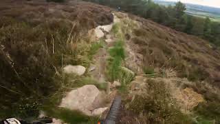
Trail from Cairn Willliam top path down through the heather and over rock slabs towards the forest road in Pitfichie Forest

Access Info

Follow the trail up towards Cairn William summit, then turn right before the standing stone to find the start of the trail at the edge of the flats rocks.

This trail is unsanctioned.

Recent Activity on Trail

Past Week
  • 3 rides
  • 16 miles average
6 Months
  • 19 rides
  • 14 miles avg distance
All
  • 169 rides
  • Last: Jun 21, 2026
c1c2c3c4
January
February
March
April
May
June
July
August
September
October
November
December
update trails status or condition

Slippy Willie Trail Reports

statusdatedescription
May 30, 2026 @ 3:32pm (Europe/London)
May 30, 2026
running perfect and clear.
Apr 10, 2026 @ 2:31pm (Europe/London)
Apr 10, 2026
Tree hanging very low about halfway through the wooded section
Feb 23, 2026 @ 1:11pm (Europe/London)
Feb 23, 2026
Running wet but grippy AF in the woods 💪🏻
Dec 12, 2025 @ 9:04am (Europe/London)
Dec 12, 2025
Clear
Oct 8, 2025 @ 7:02pm (Europe/Isle_of_Man)
Oct 8, 2025
Some more low hanging trees over the trail where last set of trees were downed
more »
Status:
on May 30, 2026
Ideal
Avg: 4.3 (7 votes)
Your vote: 0

view (1,646)
close
3D
Trail Conditions
  • Unknown
  • Snow Groomed
  • Snow Packed
  • Snow Covered
  • Snow Cover Partial
  • Freeze/thaw Cycle
  • Icy
  • Prevalent Mud
  • Wet
  • Variable
  • Ideal
  • Dry
  • Very Dry
Trail Flow (Ridden Direction)
Trailforks scans users ridelogs to determine the most popular direction each trail is ridden. A good flowing trail network will have most trails flowing in a single direction according to their intension.
The colour categories are based on what percentage of riders are riding a trail in its intended direction.
  • > 96%
  • > 90%
  • > 80%
  • > 70%
  • > 50%
  • < 50%
  • bi-directional trail
  • no data
Trail Last Ridden
Trailforks scans ridelogs to determine the last time a trail was ridden.
  • < 2 days
  • < 1 week
  • < 2 weeks
  • < 1 month
  • < 6 months
  • > 6 months
Trail Ridden Direction
The intended direction a trail should be ridden.
  • Downhill Only
  • Downhill Primary
  • Both Directions
  • Uphill Primary
  • Uphill Only
  • One Direction
Contribute Details
Colors indicate trail is missing specified detail.
  • Description
  • Photos
  • Description & Photos
  • Videos
Trail Popularity ?
Trailforks scans ridelogs to determine which trails are ridden the most in the last 9 months. Trails are compared with nearby trails in the same city region with a possible 25 colour shades. Think of this as a heatmap, more rides = more kinetic energy = warmer colors.
  • most popular
  • popular
  • less popular
  • not popular
ATV/ORV/OHV Filter
Max Vehicle Width
inches
US Cell Coverage
Legend
cell carrier legend

Radar Time
Activity Recordings
Trailforks uses anonymized public activity data. ?
Activity Recordings
Trailforks uses anonymized public activity data. ?
Personal Heatmap
Activity Types
all / none
Options
2
Date range month
Winter Trails
Warning A routing network for winter maps does not exist. Selecting trails using the winter trails layer has been disabled.
Missing Trails
Most Popular
Least Popular
Trails are colored based on popularity. The more popular a trail is, the more red. Less popular trails trend towards green.
Jump Magnitude Heatmap
Heatmap of where riders jump on trails. Zoom in to see individual jumps, click circles to view jump details.
BC Backroad Status

Service Road Atlas is a free to use, community-driven service for viewing and creating reports on the numerous back-country service roads around B.C. and Alberta.

map legend
Slope Aspect
Direction the slope faces
Flat N NE E SE S SW W NW
Trails Deemphasized
Trails are shown in grey.
disable
Only show trails with no bike usage.
Enable
Suggested Layers
Based on selected activity type

    Save the current map location and zoom level as your default home location whenever this page is loaded.

    Save
        Directions to slippy-willie trailhead (57.238130, -2.574020)

        Photos

        3 more »
        69 |
        Sep 2, 2022 @ 10:48pm
        Sep 2, 2022
        88 |
        Sep 2, 2022 @ 10:48pm
        Sep 2, 2022
        120 |
        Apr 9, 2022 @ 1:38am
        Apr 9, 2022
        17 |
        Feb 23, 2026 @ 5:11am
        Feb 23, 2026

        Videos

        5 more »
        Pitfichie Slippery Willie trail
        3:52 | 129 | May 23, 2025 , Inverurie
        Pitfichie - Slippy Willie
        4:20 | 118 | Aug 10, 2024 , Inverurie
        Pitfichie Enduro 2022 - Stage 1 Preview
        5:14 | 432 | Jun 20, 2022 , Inverurie
        Slippy Willie - Pitfichie 2022
        9:29 | 485 | Apr 21, 2022 , Inverurie

        Routes with this trail

        5.0 22 miles 3,447 ft 12 Loop Race
        Race course for the Full route in the Pitfichie Enduro - Round #1 - Aberdeenshire Enduro Series 2022 run...
        18 miles 3,226 ft 14 Loop Race
        Pitfichie Enduro 2023 - Full Route. Run by DoonThaBrae Events

        4 Reviews & Comments


        We hope you've been enjoying Trailforks!

        Create a FREE account to view trail comments and much more.

        Nearby Trails

        • #472945 - 1,807 views

        Frequently Asked Questions About Slippy Willie

        Where is Slippy Willie located?
        Slippy Willie is located in Pitfichie, Inverurie, United Kingdom. It is part of the Pitfichie trail network. The trailhead is located at coordinates 57.23813, -2.57402.
        How hard is Slippy Willie?
        Slippy Willie is rated as Black difficulty. The physical rating is Moderate. The average grade is 15.5%. The climb difficulty is rated Double Black Diamond.
        What is the elevation gain for Slippy Willie?
        The trail has 187 m of elevation descent. The elevation ranges from 243 m to 429 m.
        Is Slippy Willie a point to point trail?
        Yes, Slippy Willie is a point to point trail. The direction is One Direction. The trail type is mixed.

        Hit the Trail

        Open in App

        Get this trail on your phone instantly.
        open trail in app

        Download Trail

        Save to wishlist, Garmin & download.
        save the trail

        Find Related Routes

        Find routes and users activities that include this trail.
        find routes for this trail

        You must enter a description before submitting.