more stats
581 ft
Distance
-35 ft
Descent
00:03:00
Avg time
-38 ft
Altitude change
3,522 ft
Altitude min
3,560 ft
Altitude max
3,560 ft
Altitude start
3,520 ft
Altitude end
-6.5%
Grade
-15.9%
Grade max
-0.7%
Grade min
535 ft
Distance down
46 ft
Distance flat
00:03:00
Avg time

Slope Wars Details

  • Activities
    • Mountain Bike
  • Riding Area
    Hinton Bike Park
    Hinton, Alberta
  • Difficulty Rating
  • Voted Difficulty
    Double Black Diamond (2 votes)
  • Local Popularity
    85 in Mountain Biking
  • Global Ranking
    #43253 in Mountain Biking
  • Trail Type
    Other
  • Bike Type
    DJ
  • Direction
    Downhill Only
  • Physical Rating
    Moderate
  • Dogs Allowed
    Yes
  • eBike Allowed
  • TTFs on Trail
    Berm, Drop, Jump, Ladder Bridge, Roller Coaster, Wallride

Hinton Bike Park
A slope style track with woops, doubles, drop away, wall ride, hips and drops.

Access Info

Accessed from mid way trail. Trail sign will be on the left

Local Trail Association

Recent Activity on Trail

Past Week
  • 1 rides
  • 7 miles average
6 Months
  • 5 rides
  • 7 miles avg distance
All
  • 116 rides
  • Last: Jun 15, 2026
c1c2c3c4
January
February
March
April
May
June
July
August
September
October
November
December
update trails status or condition

Slope Wars Trail Reports

statusdatedescription
Jun 15, 2025 @ 12:11pm
Jun 15, 2025
May 5, 2023 @ 6:30pm
May 5, 2023
Sep 9, 2022 @ 1:25pm
Sep 9, 2022
Sep 1, 2022 @ 2:40pm
Sep 1, 2022
epic!
Jun 25, 2022 @ 2:03pm
Jun 25, 2022
Lots of overgrowth/weeds on parts of trail — just needs a bit of maintenance.
more »
Status:
on Jun 15, 2025
Ideal
Avg: 4.45 (14 votes)
Your vote: 0

view (1,289)
close
3D
Trail Conditions
  • Unknown
  • Snow Groomed
  • Snow Packed
  • Snow Covered
  • Snow Cover Partial
  • Freeze/thaw Cycle
  • Icy
  • Prevalent Mud
  • Wet
  • Variable
  • Ideal
  • Dry
  • Very Dry
Trail Flow (Ridden Direction)
Trailforks scans users ridelogs to determine the most popular direction each trail is ridden. A good flowing trail network will have most trails flowing in a single direction according to their intension.
The colour categories are based on what percentage of riders are riding a trail in its intended direction.
  • > 96%
  • > 90%
  • > 80%
  • > 70%
  • > 50%
  • < 50%
  • bi-directional trail
  • no data
Trail Last Ridden
Trailforks scans ridelogs to determine the last time a trail was ridden.
  • < 2 days
  • < 1 week
  • < 2 weeks
  • < 1 month
  • < 6 months
  • > 6 months
Trail Ridden Direction
The intended direction a trail should be ridden.
  • Downhill Only
  • Downhill Primary
  • Both Directions
  • Uphill Primary
  • Uphill Only
  • One Direction
Contribute Details
Colors indicate trail is missing specified detail.
  • Description
  • Photos
  • Description & Photos
  • Videos
Trail Popularity ?
Trailforks scans ridelogs to determine which trails are ridden the most in the last 9 months. Trails are compared with nearby trails in the same city region with a possible 25 colour shades. Think of this as a heatmap, more rides = more kinetic energy = warmer colors.
  • most popular
  • popular
  • less popular
  • not popular
ATV/ORV/OHV Filter
Max Vehicle Width
inches
US Cell Coverage
Legend
cell carrier legend

Radar Time
Activity Recordings
Trailforks uses anonymized public activity data. ?
Activity Recordings
Trailforks uses anonymized public activity data. ?
Personal Heatmap
Activity Types
all / none
Options
2
Date range month
Winter Trails
Warning A routing network for winter maps does not exist. Selecting trails using the winter trails layer has been disabled.
Missing Trails
Most Popular
Least Popular
Trails are colored based on popularity. The more popular a trail is, the more red. Less popular trails trend towards green.
Jump Magnitude Heatmap
Heatmap of where riders jump on trails. Zoom in to see individual jumps, click circles to view jump details.
BC Backroad Status

Service Road Atlas is a free to use, community-driven service for viewing and creating reports on the numerous back-country service roads around B.C. and Alberta.

map legend
Slope Aspect
Direction the slope faces
Flat N NE E SE S SW W NW
Trails Deemphasized
Trails are shown in grey.
disable
Only show trails with no bike usage.
Enable
Suggested Layers
Based on selected activity type

    Save the current map location and zoom level as your default home location whenever this page is loaded.

    Save
        Directions to slope-wars trailhead (53.389080, -117.576810)

        Photos

        55 more »
        575 |
        Jan 27, 2011 @ 9:27am
        Jan 27, 2011
        627 |
        May 19, 2013 @ 10:57pm
        May 19, 2013
        101 |
        Jun 18, 2020 @ 11:50am
        Jun 18, 2020
        92 |
        Jun 18, 2020 @ 11:50am
        Jun 18, 2020

        Videos

        6 more »
        Slope Wars Crash
        0:40 | 736 | Aug 15, 2011 , Hinton
        Hinton
        2:01 | 370 | May 22, 2011 , Hinton
        One Crank Faster- Segment 2
        0:15 | 317 | May 4, 2010 , Hinton
        Slope Wars
        0:44 | 700 | Aug 30, 2011 , Hinton

        1 Review & Comments


        We hope you've been enjoying Trailforks!

        Create a FREE account to view trail comments and much more.

        • By napsack & contributors
        • #16494 - 2,686 views

        Frequently Asked Questions About Slope Wars

        Where is Slope Wars located?
        Slope Wars is located in Hinton Bike Park, Hinton, Alberta, Canada. It is part of the Hinton Bike Park trail network. The trailhead is located at coordinates 53.38908, -117.57681.
        How hard is Slope Wars?
        Slope Wars is rated as Black Diamond difficulty. The physical rating is Moderate. The average grade is 6.5%.
        What is the elevation gain for Slope Wars?
        The trail has 35 ft of elevation descent. The elevation ranges from 3,522 ft to 3,560 ft.
        Is Slope Wars a point to point trail?
        Yes, Slope Wars is a point to point trail. The direction is Downhill Only. The trail type is other.

        Hit the Trail

        Open in App

        Get this trail on your phone instantly.
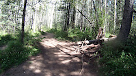
        open trail in app

        Download Trail

        Save to wishlist, Garmin & download.
        save the trail

        Find Related Routes

        Find routes and users activities that include this trail.
        find routes for this trail

        You must enter a description before submitting.