more stats
906 ft
Distance
-176 ft
Descent
1,145 ft
High Point
-176 ft
Altitude change
969 ft
Altitude min
1,145 ft
Altitude start
971 ft
Altitude end
-19.4%
Grade
-40.1%
Grade max
-3.4%
Grade min
906 ft
Distance down

Snakebite Details

  • Activities
    • Mountain Bike
    • E-Bike
  • Riding Area
    Drumtochty
    Laurencekirk
  • Difficulty Rating
  • Local Popularity
    85 in Mountain Biking [+]
    • 90 in E-Biking
  • Global Ranking
    #159381 in Mountain Biking [+]
    • #26939 in E-Biking
  • Trail Type
    Singletrack
  • Bike Type
    DH, AM
  • Trail Visibility
    Always easy to follow
  • eBike Allowed
    Yes up to Class 1
  • TTFs on Trail
    Berm, Drop
  • Year Opened
    2025

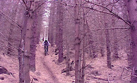
A steeper “bite-sized” version of The Serpent, with an option of a red or black graded finish. Start as per Spare Ribs. Turn on to The Serpent and immediately turn off to the right.

Follow easy angled turns with wind blown trees on both sides. A small step feature provides access to a moss floored clearing. Follow the trail cut through lichen covered larch trees, with an uncut mossy rut back into the spruce forest.

A short, root section leads to runnels between the tree rows. Reach an obvious terrace where there is an option to finish the trail down to the fire-road.

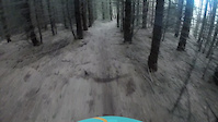
Red Option - Turn left and follow the terrace to a moderately steep section between the trees, that leads down to another terrace, under the log drop feature. Continue down to the embankment to the fire road.

Black Option - Drop over the terrace (or squeeze around the terrace to the right). Complete a steep, committing drop over a fallen tree trunk into a gravel bowl. Veer right, down the fire road embankment to complete the trail.

The trail finishes at the top of Papa Delta, that can be followed for a longer trail experience.

This trail is unsanctioned.

Recent Activity on Trail

Past Week
  • 0 rides
  •  
6 Months
  • 6 rides
  • 15 miles avg distance
All
  • 25 rides
  • Last: Jun 6, 2026
c1c2c3c4
January
February
March
April
May
June
July
August
September
October
November
December
update trails status or condition

Snakebite Trail Reports

statusdatedescription
May 19, 2026 @ 6:51am (Europe/London)
May 18, 2026
Direct line access to the steps has been cleared to the right of the original trail, allowing the rider to enter this part of the trail without...
Sep 27, 2025 @ 5:37pm (Europe/London)
Sep 27, 2025
Terrace added to help access to the red finish traverse, that allows the rider to come in under the log drop feature. The black finish is still...
Sep 13, 2025 @ 8:21pm (Europe/London)
Sep 13, 2025
The drop feature at the top of the trail has been tidied up with more gravel fill.
Apr 4, 2025 @ 7:42am
Apr 4, 2025
Agree that log drop is a black feature. Brushed some of the excessively loose stuff off the top of the landing by hand/foot as it was a bit sketchy
Feb 22, 2025 @ 10:02am
Feb 22, 2025
Main line (original taped line) completed, continuing the descending traverse across the hillside and coming back in below the log drop. The...
more »
Status:
on May 19, 2026
Ideal
no votes yet
Your vote: 0

view (188)
close
3D
Trail Conditions
  • Unknown
  • Snow Groomed
  • Snow Packed
  • Snow Covered
  • Snow Cover Partial
  • Freeze/thaw Cycle
  • Icy
  • Prevalent Mud
  • Wet
  • Variable
  • Ideal
  • Dry
  • Very Dry
Trail Flow (Ridden Direction)
Trailforks scans users ridelogs to determine the most popular direction each trail is ridden. A good flowing trail network will have most trails flowing in a single direction according to their intension.
The colour categories are based on what percentage of riders are riding a trail in its intended direction.
  • > 96%
  • > 90%
  • > 80%
  • > 70%
  • > 50%
  • < 50%
  • bi-directional trail
  • no data
Trail Last Ridden
Trailforks scans ridelogs to determine the last time a trail was ridden.
  • < 2 days
  • < 1 week
  • < 2 weeks
  • < 1 month
  • < 6 months
  • > 6 months
Trail Ridden Direction
The intended direction a trail should be ridden.
  • Downhill Only
  • Downhill Primary
  • Both Directions
  • Uphill Primary
  • Uphill Only
  • One Direction
Contribute Details
Colors indicate trail is missing specified detail.
  • Description
  • Photos
  • Description & Photos
  • Videos
Trail Popularity ?
Trailforks scans ridelogs to determine which trails are ridden the most in the last 9 months. Trails are compared with nearby trails in the same city region with a possible 25 colour shades. Think of this as a heatmap, more rides = more kinetic energy = warmer colors.
  • most popular
  • popular
  • less popular
  • not popular
ATV/ORV/OHV Filter
Max Vehicle Width
inches
US Cell Coverage
Legend
cell carrier legend

Radar Time
Activity Recordings
Trailforks uses anonymized public activity data. ?
Activity Recordings
Trailforks uses anonymized public activity data. ?
Personal Heatmap
Activity Types
all / none
Options
2
Date range month
Winter Trails
Warning A routing network for winter maps does not exist. Selecting trails using the winter trails layer has been disabled.
Missing Trails
Most Popular
Least Popular
Trails are colored based on popularity. The more popular a trail is, the more red. Less popular trails trend towards green.
Jump Magnitude Heatmap
Heatmap of where riders jump on trails. Zoom in to see individual jumps, click circles to view jump details.
BC Backroad Status

Service Road Atlas is a free to use, community-driven service for viewing and creating reports on the numerous back-country service roads around B.C. and Alberta.

map legend
Slope Aspect
Direction the slope faces
Flat N NE E SE S SW W NW
Trails Deemphasized
Trails are shown in grey.
disable
Only show trails with no bike usage.
Enable
Suggested Layers
Based on selected activity type

    Save the current map location and zoom level as your default home location whenever this page is loaded.

    Save
        Directions to snakebite-826259 trailhead (56.889750, -2.505300)

        Photos

        8 more »
        40 |
        Feb 13, 2025 @ 11:21am
        Feb 13, 2025
        34 |
        Feb 13, 2025 @ 11:13am
        Feb 13, 2025
        33 |
        Feb 13, 2025 @ 11:12am
        Feb 13, 2025
        32 |
        Feb 13, 2025 @ 11:12am
        Feb 13, 2025

        Videos

        2 more »
        Snakebite Mid Section
        0:27 | 9 | Jun 3, 2026 , Laurencekirk
        Snakebite - first run
        0:25 | | Feb 13, 2025 , Laurencekirk

        Reviews / Comments

        No reviews yet, be the first to write a review or ask a question.
        Use trail reports to comment on trail conditions.


        We hope you've been enjoying Trailforks!

        Create a FREE account to view trail comments and much more.

        • #826259 - 240 views

        Frequently Asked Questions About Snakebite

        Where is Snakebite located?
        Snakebite is located in Drumtochty, Laurencekirk, United Kingdom. It is part of the Drumtochty trail network. The trailhead is located at coordinates 56.88975, -2.5053.
        How hard is Snakebite?
        Snakebite is rated as Red difficulty. The average grade is 19.4%.
        What is the elevation gain for Snakebite?
        The trail has 176 ft of elevation descent. The elevation ranges from 969 ft to 1,145 ft.
        How long is Snakebite?
        Snakebite is 906 ft long. The trail type is singletrack.

        Hit the Trail

        Open in App

        Get this trail on your phone instantly.
        open trail in app

        Download Trail

        Save to wishlist, Garmin & download.
        save the trail

        Find Related Routes

        Find routes and users activities that include this trail.
        find routes for this trail

        You must enter a description before submitting.