more stats
4,216 ft
Distance
105 ft
Climb
-103 ft
Descent
00:25:33
Avg time
2 ft
Altitude change
1,929 ft
Altitude min
2,036 ft
Altitude max
1,965 ft
Altitude start
1,965 ft
Altitude end
-19.3%
Grade max
40%
Grade min
1,713 ft
Distance climb
2,165 ft
Distance down
338 ft
Distance flat
00:25:33
Avg time

Sol Duc Falls Details

  • Activities
    • Hike
    • Trail Running
  • Riding Area
    Olympic National Park
    Port Angeles, Washington
  • Difficulty Rating
  • Local Popularity
    100 in Hiking [+]
    • 100 in Trail Running
  • Global Ranking
    #43 in Hiking [+]
    • #11820 in Trail Running
  • Hiking SAC Scale
    T1 Hiking
  • Trail Type
    Wilderness Trail
  • Direction
    Both Directions
  • Physical Rating
    Easy
  • Trail Visibility
    Always easy to follow
  • Season
    year round, weather perrmitting
  • Alpine Trail
    Yes
  • Family Friendly
    Yes
  • eBike Allowed
  • Year Opened
    2021

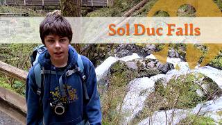
Old growth forest trail to cascading waterfall.

Access Info

Sol Duc road to trailhead is open year round, weather permitting. Large parking lot and pit toilets at trailhead. Paved road is inside Olympic National Park, park access fee or pass required.

Traditionally Indigenous Territory

Recent Activity on Trail

Past Week
  • 2 rides
  • 27 miles average
6 Months
  • 24 rides
  • 7 miles avg distance
All
  • 111 rides
  •  
c1c2c3c4
January
February
March
April
May
June
July
August
September
October
November
December
update trails status or condition

Sol Duc Falls Trail Reports

statusdatedescription
Aug 4, 2024 @ 7:20am
Aug 4, 2024
Beautiful. Busy.
Jul 4, 2022 @ 10:45am
Jul 4, 2022
more »
Status:
on Aug 4, 2024
Dry
Avg: 4.01 (1 votes)
Your vote: 0

view (1,074)
close
3D
Trail Conditions
  • Unknown
  • Snow Groomed
  • Snow Packed
  • Snow Covered
  • Snow Cover Partial
  • Freeze/thaw Cycle
  • Icy
  • Prevalent Mud
  • Wet
  • Variable
  • Ideal
  • Dry
  • Very Dry
Trail Flow (Ridden Direction)
Trailforks scans users ridelogs to determine the most popular direction each trail is ridden. A good flowing trail network will have most trails flowing in a single direction according to their intension.
The colour categories are based on what percentage of riders are riding a trail in its intended direction.
  • > 96%
  • > 90%
  • > 80%
  • > 70%
  • > 50%
  • < 50%
  • bi-directional trail
  • no data
Trail Last Ridden
Trailforks scans ridelogs to determine the last time a trail was ridden.
  • < 2 days
  • < 1 week
  • < 2 weeks
  • < 1 month
  • < 6 months
  • > 6 months
Trail Ridden Direction
The intended direction a trail should be ridden.
  • Downhill Only
  • Downhill Primary
  • Both Directions
  • Uphill Primary
  • Uphill Only
  • One Direction
Contribute Details
Colors indicate trail is missing specified detail.
  • Description
  • Photos
  • Description & Photos
  • Videos
Trail Popularity ?
Trailforks scans ridelogs to determine which trails are ridden the most in the last 9 months. Trails are compared with nearby trails in the same city region with a possible 25 colour shades. Think of this as a heatmap, more rides = more kinetic energy = warmer colors.
  • most popular
  • popular
  • less popular
  • not popular
ATV/ORV/OHV Filter
Max Vehicle Width
inches
US Cell Coverage
Legend
cell carrier legend

Radar Time
Activity Recordings
Trailforks uses anonymized public activity data. ?
Activity Recordings
Trailforks uses anonymized public activity data. ?
Personal Heatmap
Activity Types
all / none
Options
2
Date range month
Winter Trails
Warning A routing network for winter maps does not exist. Selecting trails using the winter trails layer has been disabled.
Missing Trails
Most Popular
Least Popular
Trails are colored based on popularity. The more popular a trail is, the more red. Less popular trails trend towards green.
Jump Magnitude Heatmap
Heatmap of where riders jump on trails. Zoom in to see individual jumps, click circles to view jump details.
BC Backroad Status

Service Road Atlas is a free to use, community-driven service for viewing and creating reports on the numerous back-country service roads around B.C. and Alberta.

map legend
Slope Aspect
Direction the slope faces
Flat N NE E SE S SW W NW
Trails Deemphasized
Trails are shown in grey.
disable
Only show trails with no bike usage.
Enable
Suggested Layers
Based on selected activity type

    Save the current map location and zoom level as your default home location whenever this page is loaded.

    Save
        Directions to sol-duc-falls trailhead (47.954820, -123.834880)

        Photos

        7 more »
        20 |
        May 2, 2026 @ 5:33pm
        May 2, 2026
        11 |
        May 2, 2026 @ 5:33pm
        May 2, 2026
        15 |
        May 2, 2026 @ 5:33pm
        May 2, 2026
        15 |
        Apr 26, 2026 @ 9:14pm
        Apr 26, 2026

        Videos

        1 more »
        Sol Duc Falls - Erik's 40th Birthday Hike
        3:05 | 8 | Apr 26, 2026 , Port Angeles

        Routes with this trail

        15 miles 3,465 ft 6 Loop
        Generally considered a highly challenging route, it takes an average of 7 h 55 min to complete and should...
        2 miles 209 ft 2 Out & Back
        An easy round trip hike to picturesque .
        52 miles 16,204 ft 7 Loop
        Bailey Range Traverse Loop, starting and ending at Sol Duc TH.

        Reviews / Comments

        No reviews yet, be the first to write a review or ask a question.
        Use trail reports to comment on trail conditions.


        We hope you've been enjoying Trailforks!

        Create a FREE account to view trail comments and much more.

        • By gnarlordTF Pro & contributors
        • #453428 - 1,463 views

        Frequently Asked Questions About Sol Duc Falls

        Where is Sol Duc Falls located?
        Sol Duc Falls is located in Olympic National Park, Port Angeles, Washington, United States. It is part of the Olympic National Park trail network. The trailhead is located at coordinates 47.95482, -123.83488.
        How hard is Sol Duc Falls?
        Sol Duc Falls is rated as Green difficulty. The physical rating is Easy.
        What is the elevation gain for Sol Duc Falls?
        Sol Duc Falls has 105 ft of elevation gain. The trail has 103 ft of elevation descent. The elevation ranges from 1,929 ft to 2,036 ft.
        Is Sol Duc Falls a point to point trail?
        Sol Duc Falls is not a point to point trail. The direction is Both Directions. The trail type is wilderness trail.

        Hit the Trail

        Open in App

        Get this trail on your phone instantly.
        open trail in app

        Download Trail

        Save to wishlist, Garmin & download.
        save the trail

        Find Related Routes

        Find routes and users activities that include this trail.
        find routes for this trail

        You must enter a description before submitting.