more stats
1.0 mile
Distance
42 ft
Climb
-93 ft
Descent
00:08:40
Avg time
-51 ft
Altitude change
359 ft
Altitude min
447 ft
Altitude max
414 ft
Altitude start
364 ft
Altitude end
-0.9%
Grade
-29.4%
Grade max
14%
Grade min
1,539 ft
Distance climb
2,516 ft
Distance down
1,434 ft
Distance flat
00:08:40
Avg time

Southern Traverse Details

  • Activities
    • Mountain Bike
    • Horse
    • Hike
    • Trail Running
  • Riding Area
  • Difficulty Rating
  • Voted Difficulty
    Blue (2 votes)
  • Local Popularity
    70 in Mountain Biking [+]
    • 45 in Trail Running
    • 65 in Hiking
    • 5 in Horseback
  • Global Ranking
    #90964 in Mountain Biking [+]
    • #120397 in Trail Running
    • #89768 in Hiking
    • #1618 in Horseback
  • Hiking SAC Scale
    T1 Hiking
  • Trail Type
    Singletrack
  • Bike Type
    AM, XC
  • Direction
    Both Directions
  • Climb Difficulty
    Blue
  • Physical Rating
    Moderate
  • Season
    Any
  • Dogs Allowed
    Yes
  • eBike Allowed

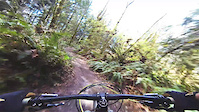
Fast trail, (gravel path on the east end) with some roots and rocks along the way.
A nice long ladder bridge over a muddy section. Horses not allowed on bridge but there is a walk-around.
Be aware it doesn't take you back to the main parking lot. You'll have to rough it out on Lloyd's.

Local Trail Association
Traditionally Indigenous Territory

Recent Activity on Trail

Past Week
  • 2 rides
  • 10 miles average
6 Months
  • 45 rides
  • 11 miles avg distance
All
  • 367 rides
  • Last: Jun 21, 2026
c1c2c3c4
January
February
March
April
May
June
July
August
September
October
November
December
update trails status or condition

Southern Traverse Trail Reports

statusdatedescription
Nov 19, 2025 @ 7:42am (America/Los_Angeles)
Nov 19, 2025
All of Southern Traverse has been raked and blown.
Nov 12, 2025 @ 4:11pm (America/Los_Angeles)
Nov 12, 2025
Freshly leaf blown from Mainline to Lloyd's intersection.
Jul 25, 2025 @ 10:56am
Jul 25, 2025
Tree down on trail on Southern Traverse about a quarter to half mile in from the road (going towards Lloyds)
Jul 13, 2025 @ 9:30am
Jul 13, 2025
Small tree down across the trail about 1/2-3/4 of way on during the climb towards Lloyd's.
Apr 15, 2025 @ 5:57pm
Apr 15, 2025
more »
Status:
on Nov 19, 2025
Ideal
Avg: 3.81 (5 votes)
Your vote: 0

view (1,363)
close
3D
Trail Conditions
  • Unknown
  • Snow Groomed
  • Snow Packed
  • Snow Covered
  • Snow Cover Partial
  • Freeze/thaw Cycle
  • Icy
  • Prevalent Mud
  • Wet
  • Variable
  • Ideal
  • Dry
  • Very Dry
Trail Flow (Ridden Direction)
Trailforks scans users ridelogs to determine the most popular direction each trail is ridden. A good flowing trail network will have most trails flowing in a single direction according to their intension.
The colour categories are based on what percentage of riders are riding a trail in its intended direction.
  • > 96%
  • > 90%
  • > 80%
  • > 70%
  • > 50%
  • < 50%
  • bi-directional trail
  • no data
Trail Last Ridden
Trailforks scans ridelogs to determine the last time a trail was ridden.
  • < 2 days
  • < 1 week
  • < 2 weeks
  • < 1 month
  • < 6 months
  • > 6 months
Trail Ridden Direction
The intended direction a trail should be ridden.
  • Downhill Only
  • Downhill Primary
  • Both Directions
  • Uphill Primary
  • Uphill Only
  • One Direction
Contribute Details
Colors indicate trail is missing specified detail.
  • Description
  • Photos
  • Description & Photos
  • Videos
Trail Popularity ?
Trailforks scans ridelogs to determine which trails are ridden the most in the last 9 months. Trails are compared with nearby trails in the same city region with a possible 25 colour shades. Think of this as a heatmap, more rides = more kinetic energy = warmer colors.
  • most popular
  • popular
  • less popular
  • not popular
ATV/ORV/OHV Filter
Max Vehicle Width
inches
US Cell Coverage
Legend
cell carrier legend

Radar Time
Activity Recordings
Trailforks uses anonymized public activity data. ?
Activity Recordings
Trailforks uses anonymized public activity data. ?
Personal Heatmap
Activity Types
all / none
Options
2
Date range month
Winter Trails
Warning A routing network for winter maps does not exist. Selecting trails using the winter trails layer has been disabled.
Missing Trails
Most Popular
Least Popular
Trails are colored based on popularity. The more popular a trail is, the more red. Less popular trails trend towards green.
Jump Magnitude Heatmap
Heatmap of where riders jump on trails. Zoom in to see individual jumps, click circles to view jump details.
BC Backroad Status

Service Road Atlas is a free to use, community-driven service for viewing and creating reports on the numerous back-country service roads around B.C. and Alberta.

map legend
Slope Aspect
Direction the slope faces
Flat N NE E SE S SW W NW
Trails Deemphasized
Trails are shown in grey.
disable
Only show trails with no bike usage.
Enable
Suggested Layers
Based on selected activity type

    Save the current map location and zoom level as your default home location whenever this page is loaded.

    Save
        Directions to southern-traverse trailhead (47.775980, -122.080780)

        Photos

        30 more »
        42 |
        Sep 4, 2022 @ 7:15pm
        Sep 4, 2022
        45 |
        Sep 4, 2022 @ 7:14pm
        Sep 4, 2022
        62 |
        Jul 29, 2022 @ 12:30pm
        Jul 29, 2022
        64 |
        Jul 21, 2022 @ 7:22pm
        Jul 21, 2022

        Videos

        1 more »
        Paradise Valley Quickie
        0:09 | 452 | Apr 1, 2015 , Maltby

        Routes with this trail

        6 miles 320 ft 15
        Parking lot to -> -> -> -> Big Ring & Little Ring -> -> -> Lloyd -> -> Parking Lot
        2.8 6 miles 321 ft 22 Loop
        Near-maximum trail coverage, including the most rooty Two Trees South.
        10 miles 600 ft 19 Loop
        The Optimal Route in Paradise Valley Conservation Area for maximum trail coverage

        1 Review & Comments


        We hope you've been enjoying Trailforks!

        Create a FREE account to view trail comments and much more.

        • By jebikeTF Pro & contributors
        • #17378 - 3,345 views

        Frequently Asked Questions About Southern Traverse

        Where is Southern Traverse located?
        Southern Traverse is located in Paradise Valley Conservation Area, Maltby, Washington, United States. It is part of the Paradise Valley Conservation Area trail network. The trailhead is located at coordinates 47.77598, -122.08078.
        How hard is Southern Traverse?
        Southern Traverse is rated as Green difficulty. The physical rating is Moderate. The average grade is 0.9%. The climb difficulty is rated Blue.
        What is the elevation gain for Southern Traverse?
        Southern Traverse has 42 ft of elevation gain. The trail has 93 ft of elevation descent. The elevation ranges from 359 ft to 447 ft.
        Is Southern Traverse a point to point trail?
        Southern Traverse is not a point to point trail. The direction is Both Directions. The trail type is singletrack.

        Hit the Trail

        Open in App

        Get this trail on your phone instantly.
        open trail in app

        Download Trail

        Save to wishlist, Garmin & download.
        save the trail

        Find Related Routes

        Find routes and users activities that include this trail.
        find routes for this trail

        You must enter a description before submitting.