more stats
3.4 miles
Distance
693 ft
Climb
-1,378 ft
Descent
00:37:52
Avg time
-687 ft
Altitude change
861 ft
Altitude min
1,547 ft
Altitude max
1,547 ft
Altitude start
860 ft
Altitude end
-3.8%
Grade
-51.9%
Grade max
62.3%
Grade min
1 mile
Distance climb
2 miles
Distance down
2,126 ft
Distance flat
00:37:52
Avg time

Space Mountain Details

  • Activities
    • Mountain Bike
    • E-Bike
    • Horse
    • Hike
    • Trail Running
  • Riding Area
    Conejo Canyons Open Space
    Thousand Oaks, California
  • Difficulty Rating
  • Voted Difficulty
    Blue (3 votes)
  • Local Popularity
    100 in Mountain Biking [+]
    • 95 in E-Biking
    • 85 in Trail Running
    • 50 in Hiking
    • 5 in Horseback
  • Global Ranking
    #18854 in Mountain Biking [+]
    • #1879 in E-Biking
    • #387 in Trail Running
    • #61670 in Hiking
    • #830 in Horseback
  • Trail Type
    Singletrack
  • Bike Type
    AM, XC
  • Direction
    Both Directions
  • Climb Difficulty
    Blue
  • Physical Rating
    Moderate
  • Trail Visibility
    Always easy to follow
  • Dogs Allowed
    Yes
  • eBike Allowed
    Yes up to Class 1
  • Ride in Rain
    Yes
  • Land Owner
    Conejo Open Space Conservation Agency

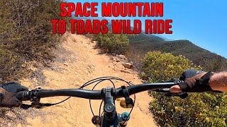
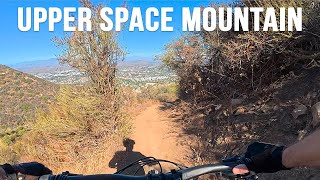
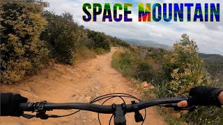
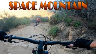
Officially this is called Los Robles Trail West. But this popular section is known to mountain bikers as space mountain. Great flowing downhill with lots of twisty turns, most of them with generous berms. The sandy soil drains nicely making this is one of the few good area trails after a rain.

Traditionally Indigenous Territory

Recent Activity on Trail

Past Week
  • 3 rides
  • 10 miles average
6 Months
  • 68 rides
  • 12 miles avg distance
All
  • 704 rides
  • Last: Jun 19, 2026
c1c2c3c4
January
February
March
April
May
June
July
August
September
October
November
December
Status:
on Jun 13, 2026
Dry
Avg: 4.18 (29 votes)
Your vote: 0

view (8,275)
close
3D
Trail Conditions
  • Unknown
  • Snow Groomed
  • Snow Packed
  • Snow Covered
  • Snow Cover Partial
  • Freeze/thaw Cycle
  • Icy
  • Prevalent Mud
  • Wet
  • Variable
  • Ideal
  • Dry
  • Very Dry
Trail Flow (Ridden Direction)
Trailforks scans users ridelogs to determine the most popular direction each trail is ridden. A good flowing trail network will have most trails flowing in a single direction according to their intension.
The colour categories are based on what percentage of riders are riding a trail in its intended direction.
  • > 96%
  • > 90%
  • > 80%
  • > 70%
  • > 50%
  • < 50%
  • bi-directional trail
  • no data
Trail Last Ridden
Trailforks scans ridelogs to determine the last time a trail was ridden.
  • < 2 days
  • < 1 week
  • < 2 weeks
  • < 1 month
  • < 6 months
  • > 6 months
Trail Ridden Direction
The intended direction a trail should be ridden.
  • Downhill Only
  • Downhill Primary
  • Both Directions
  • Uphill Primary
  • Uphill Only
  • One Direction
Contribute Details
Colors indicate trail is missing specified detail.
  • Description
  • Photos
  • Description & Photos
  • Videos
Trail Popularity ?
Trailforks scans ridelogs to determine which trails are ridden the most in the last 9 months. Trails are compared with nearby trails in the same city region with a possible 25 colour shades. Think of this as a heatmap, more rides = more kinetic energy = warmer colors.
  • most popular
  • popular
  • less popular
  • not popular
ATV/ORV/OHV Filter
Max Vehicle Width
inches
US Cell Coverage
Legend
cell carrier legend

Radar Time
Activity Recordings
Trailforks uses anonymized public activity data. ?
Activity Recordings
Trailforks uses anonymized public activity data. ?
Personal Heatmap
Activity Types
all / none
Options
2
Date range month
Winter Trails
Warning A routing network for winter maps does not exist. Selecting trails using the winter trails layer has been disabled.
Missing Trails
Most Popular
Least Popular
Trails are colored based on popularity. The more popular a trail is, the more red. Less popular trails trend towards green.
Jump Magnitude Heatmap
Heatmap of where riders jump on trails. Zoom in to see individual jumps, click circles to view jump details.
BC Backroad Status

Service Road Atlas is a free to use, community-driven service for viewing and creating reports on the numerous back-country service roads around B.C. and Alberta.

map legend
Slope Aspect
Direction the slope faces
Flat N NE E SE S SW W NW
Trails Deemphasized
Trails are shown in grey.
disable
Only show trails with no bike usage.
Enable
Suggested Layers
Based on selected activity type

    Save the current map location and zoom level as your default home location whenever this page is loaded.

    Save
        Directions to space-mountain trailhead (34.165590, -118.918800)

        Photos

        72 more »
        28 |
        Jun 11, 2026 @ 9:34am
        Jun 11, 2026
        8 |
        Jun 11, 2026 @ 9:33am
        Jun 11, 2026
        8 |
        Jun 11, 2026 @ 9:33am
        Jun 11, 2026
        5 |
        Jun 11, 2026 @ 9:33am
        Jun 11, 2026

        Videos

        20 more »
        youtuber Space Mountain to Toads Wild Ride - Mountain...
        10:13 | 186 | Jul 1, 2025 , Thousand Oaks
        youtuber Upper Space Mountain Trail - Mountain Biking -...
        8:08 | 202 | Oct 31, 2024 , Thousand Oaks
        youtuber Space Mountain to Toads Wild Ride - Mountain...
        9:48 | 484 | May 24, 2023 , Thousand Oaks
        youtuber Space Mountain Trail -  Mountain Biking -...
        7:11 | 650 | Jun 18, 2022 , Thousand Oaks

        Trail Lists

        Routes with this trail

        19 miles 3,407 ft 4 Loop
        3 trails 3 climbs , dry terrain , medium level
        18 miles 3,374 ft 22 Loop
        If you start at Triunfo Park you can take some fun trails to Space Mountain which you will climb and then...
        1.0 12 miles 2,021 ft 7 Out & Back
        Thousand Oaks from Morepark Road to Newbury Park on the ridge route.

        19 Reviews & Comments


        We hope you've been enjoying Trailforks!

        Create a FREE account to view trail comments and much more.

        Frequently Asked Questions About Space Mountain

        Where is Space Mountain located?
        Space Mountain is located in Conejo Canyons Open Space, Thousand Oaks, California, United States. It is part of the Conejo Canyons Open Space trail network. The trailhead is located at coordinates 34.16559, -118.9188.
        How hard is Space Mountain?
        Space Mountain is rated as Blue difficulty. The physical rating is Moderate. The average grade is 3.8%. The climb difficulty is rated Blue.
        What is the elevation gain for Space Mountain?
        Space Mountain has 693 ft of elevation gain. The trail has 1,378 ft of elevation descent. The elevation ranges from 861 ft to 1,547 ft.
        Is Space Mountain a point to point trail?
        Space Mountain is not a point to point trail. The direction is Both Directions. The trail type is singletrack.

        Hit the Trail

        Open in App

        Get this trail on your phone instantly.
        open trail in app

        Download Trail

        Save to wishlist, Garmin & download.
        save the trail

        Find Related Routes

        Find routes and users activities that include this trail.
        find routes for this trail

        You must enter a description before submitting.