more stats
5,273 ft
Distance
59 ft
Climb
-433 ft
Descent
00:11:12
Avg time
-374 ft
Altitude change
930 ft
Altitude min
1,333 ft
Altitude max
1,303 ft
Altitude start
930 ft
Altitude end
-7.086%
Grade
-21.859%
Grade max
15.426%
Grade min
774 ft
Distance climb
4,143 ft
Distance down
357 ft
Distance flat
00:11:12
Avg time

Spectrum Details

  • Activities
    • Mountain Bike
    • E-Bike
    • Winter Fat Bike
    • Hike
    • Trail Running
  • Riding Area
    Westlake Village
    California
  • Difficulty Rating
  • Voted Difficulty
    Blue (1 vote)
  • Local Popularity
    85 in Mountain Biking [+]
    • 50 in E-Biking
    • 5 in Trail Running
    • 5 in Hiking
  • Global Ranking
    #70424 in Mountain Biking [+]
    • #81859 in E-Biking
    • #233768 in Trail Running
    • #285709 in Hiking
  • Trail Type
    Singletrack
  • Bike Type
    AM, XC, Fat
  • Direction
    Downhill Primary
    Popular Direction Shown
  • Climb Difficulty
    Blue
  • Physical Rating
    Moderate
  • Trail Visibility
    Always easy to follow
  • Dogs Allowed
    Yes
  • eBike Allowed
    Yes up to Class 1
  • TTFs on Trail
    Ladder Bridge, Rock Garden

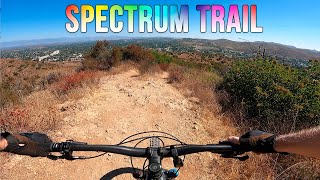
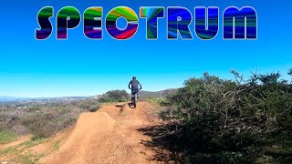
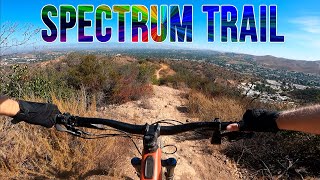
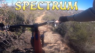
This is a newer singletrack trail that you can take from the main Triunfo Canyon area back out to the road. Its rocky and loose and pretty fun. Trail ends at the East parking lot of the Athletic Society training facility (Previously Spectrum)

Local Trail Association
Traditionally Indigenous Territory

Recent Activity on Trail

Past Week
  • 1 rides
  • 14 miles average
6 Months
  • 83 rides
  • 9 miles avg distance
All
  • 302 rides
  • Last: Apr 2, 2026
c1c2c3c4
January
February
March
April
May
June
July
August
September
October
November
December
update trails status or condition

Spectrum Trail Reports

statusdatedescription
Nov 26, 2025 @ 5:44pm (America/Los_Angeles)
Nov 26, 2025
Running good with some Spectrum characteristic loose rocks.
Nov 25, 2025 @ 3:00pm (America/Los_Angeles)
Nov 25, 2025
Trail fairies did beautiful work. Still sketchy in bits but that's as it should be. Ending is massively improved.
Oct 28, 2025 @ 11:57am (America/Los_Angeles)
Oct 28, 2025
Pretty loose and rutty in some spots but still clear.
Mar 8, 2025 @ 6:01am
Mar 8, 2025
Nothing too techy, fun and doable on a hard tail. Last section seemed plowed to maybe combat the fire but no issues
Nov 13, 2024 @ 7:13pm
Nov 13, 2024
Really dry and loose but still fun. Some steep loose sections that ride a little rowdy rn
more »
Status:
on Nov 26, 2025
Ideal
Avg: 3.99 (5 votes)
Your vote: 0

view (3,765)
close
3D
Trail Conditions
  • Unknown
  • Snow Groomed
  • Snow Packed
  • Snow Covered
  • Snow Cover Partial
  • Freeze/thaw Cycle
  • Icy
  • Prevalent Mud
  • Wet
  • Variable
  • Ideal
  • Dry
  • Very Dry
Trail Flow (Ridden Direction)
Trailforks scans users ridelogs to determine the most popular direction each trail is ridden. A good flowing trail network will have most trails flowing in a single direction according to their intension.
The colour categories are based on what percentage of riders are riding a trail in its intended direction.
  • > 96%
  • > 90%
  • > 80%
  • > 70%
  • > 50%
  • < 50%
  • bi-directional trail
  • no data
Trail Last Ridden
Trailforks scans ridelogs to determine the last time a trail was ridden.
  • < 2 days
  • < 1 week
  • < 2 weeks
  • < 1 month
  • < 6 months
  • > 6 months
Trail Ridden Direction
The intended direction a trail should be ridden.
  • Downhill Only
  • Downhill Primary
  • Both Directions
  • Uphill Primary
  • Uphill Only
  • One Direction
Contribute Details
Colors indicate trail is missing specified detail.
  • Description
  • Photos
  • Description & Photos
  • Videos
Trail Popularity ?
Trailforks scans ridelogs to determine which trails are ridden the most in the last 9 months. Trails are compared with nearby trails in the same city region with a possible 25 colour shades. Think of this as a heatmap, more rides = more kinetic energy = warmer colors.
  • most popular
  • popular
  • less popular
  • not popular
ATV/ORV/OHV Filter
Max Vehicle Width
inches
US Cell Coverage
Legend
cell carrier legend

Radar Time
Activity Recordings
Trailforks uses anonymized public activity data. ?
Activity Recordings
Trailforks uses anonymized public activity data. ?
Personal Heatmap
Activity Types
all / none
Options
2
Date range month
Winter Trails
Warning A routing network for winter maps does not exist. Selecting trails using the winter trails layer has been disabled.
Missing Trails
Most Popular
Least Popular
Trails are colored based on popularity. The more popular a trail is, the more red. Less popular trails trend towards green.
Jump Magnitude Heatmap
Heatmap of where riders jump on trails. Zoom in to see individual jumps, click circles to view jump details.
BC Backroad Status

Service Road Atlas is a free to use, community-driven service for viewing and creating reports on the numerous back-country service roads around B.C. and Alberta.

map legend
Slope Aspect
Direction the slope faces
Flat N NE E SE S SW W NW
Trails Deemphasized
Trails are shown in grey.
disable
Only show trails with no bike usage.
Enable
Suggested Layers
Based on selected activity type

    Save the current map location and zoom level as your default home location whenever this page is loaded.

    Save
        Directions to spectrum trailhead (34.163710, -118.851010)

        Photos

        16 more »
        46 |
        Jul 29, 2024 @ 11:52am
        Jul 29, 2024
        99 |
        Feb 7, 2021 @ 6:09pm
        Feb 7, 2021
        82 |
        Feb 7, 2021 @ 6:09pm
        Feb 7, 2021
        136 |
        Feb 7, 2021 @ 6:09pm
        Feb 7, 2021

        Videos

        10 more »
        youtuber Spectrum Trail - Mountain Biking - Thousand...
        4:57 | 188 | Jul 29, 2024 , My City
        youtuber Spectrum Trail with New Jumps & Berms (and...
        3:25 | 413 | Jan 20, 2023 , My City
        youtuber Spectrum Trail - Mountain Biking - Thousand...
        3:23 | 338 | Jul 21, 2022 , My City
        youtuber Spectrum Trail - Mountain Biking - Thousand...
        3:49 | 406 | Jan 3, 2022 , My City

        2 Reviews & Comments


        We hope you've been enjoying Trailforks!

        Create a FREE account to view trail comments and much more.

        • By mtbcommunity-comTF Pro & contributors
        • #189799 - 3,462 views

        Frequently Asked Questions About Spectrum

        Where is Spectrum located?
        Spectrum is located in Westlake Village, California, United States. It is part of the Westlake Village trail network. The trailhead is located at coordinates 34.16371, -118.85101.
        How hard is Spectrum?
        Spectrum is rated as Blue difficulty. The physical rating is Moderate. The average grade is 7.086%. The climb difficulty is rated Blue.
        What is the elevation gain for Spectrum?
        Spectrum has 59 ft of elevation gain. The trail has 433 ft of elevation descent. The elevation ranges from 930 ft to 1,333 ft.
        Is Spectrum a point to point trail?
        Spectrum is not a point to point trail. The direction is Downhill Primary. The trail type is singletrack.

        Hit the Trail

        Open in App

        Get this trail on your phone instantly.
        open trail in app

        Download Trail

        Save to wishlist, Garmin & download.
        save the trail

        Find Related Routes

        Find routes and users activities that include this trail.
        find routes for this trail

        You must enter a description before submitting.