more stats
1,506 ft
Distance
-156 ft
Descent
00:03:45
Avg time
-157 ft
Altitude change
137 ft
Altitude min
294 ft
Altitude max
294 ft
Altitude start
138 ft
Altitude end
-10.4%
Grade
-22.7%
Grade max
-2.2%
Grade min
1,506 ft
Distance down
00:03:45
Avg time

Stare DH Details

  • Activities
    • Mountain Bike
    • E-Bike
  • Riding Area
  • Difficulty Rating
  • Local Popularity
    95 in Mountain Biking [+]
    • 85 in E-Biking
  • Global Ranking
    #37044 in Mountain Biking [+]
    • #24690 in E-Biking
  • Trail Type
    Singletrack
  • Bike Type
    DH, AM
  • Direction
    Downhill Only
  • Physical Rating
    Moderate
  • Trail Visibility
    Always easy to follow
  • Season
    All year
  • Dogs Allowed
    Yes
  • eBike Allowed
    Yes up to Class 1
  • TTFs on Trail
    Berm, Jump, Gap Jump
  • Ride in Rain
    Yes
  • Land Owner

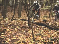
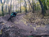
Stare DH (znane też jako Zameczek, Wieża, Klasyk) - jedna z najpopularniejszych i najstarszych tras w Puszczy Wkrzańskiej. Jest tu kilka mniejszych i większych hop, band i całkiem spory spadek wysokości. Gap jumpy w środku trasy i na dole tylko dla doświadczonych skoczków. Trasa przecina dwie często uczęszczane przez pieszych drogi leśne, więc należy zachować ostrożność.

Stare DH (aka Zameczek, Wieża) - one of the oldest and most popular trali in Wkrzańska Forest. It has several jumps and berms and It is quite steep. Big gap jumps in the middle and at the end of the trail only for advanced riders. Watch out for hickers.

This trail is unsanctioned.

Recent Activity on Trail

Past Week
  • 3 rides
  • 9 miles average
6 Months
  • 20 rides
  • 14 miles avg distance
All
  • 357 rides
  • Last: Jun 17, 2026
c1c2c3c4
January
February
March
April
May
June
July
August
September
October
November
December
Status:
on Jun 16, 2026
Ideal
Avg: 4.38 (7 votes)
Your vote: 0

view (2,137)
close
3D
Trail Conditions
  • Unknown
  • Snow Groomed
  • Snow Packed
  • Snow Covered
  • Snow Cover Partial
  • Freeze/thaw Cycle
  • Icy
  • Prevalent Mud
  • Wet
  • Variable
  • Ideal
  • Dry
  • Very Dry
Trail Flow (Ridden Direction)
Trailforks scans users ridelogs to determine the most popular direction each trail is ridden. A good flowing trail network will have most trails flowing in a single direction according to their intension.
The colour categories are based on what percentage of riders are riding a trail in its intended direction.
  • > 96%
  • > 90%
  • > 80%
  • > 70%
  • > 50%
  • < 50%
  • bi-directional trail
  • no data
Trail Last Ridden
Trailforks scans ridelogs to determine the last time a trail was ridden.
  • < 2 days
  • < 1 week
  • < 2 weeks
  • < 1 month
  • < 6 months
  • > 6 months
Trail Ridden Direction
The intended direction a trail should be ridden.
  • Downhill Only
  • Downhill Primary
  • Both Directions
  • Uphill Primary
  • Uphill Only
  • One Direction
Contribute Details
Colors indicate trail is missing specified detail.
  • Description
  • Photos
  • Description & Photos
  • Videos
Trail Popularity ?
Trailforks scans ridelogs to determine which trails are ridden the most in the last 9 months. Trails are compared with nearby trails in the same city region with a possible 25 colour shades. Think of this as a heatmap, more rides = more kinetic energy = warmer colors.
  • most popular
  • popular
  • less popular
  • not popular
ATV/ORV/OHV Filter
Max Vehicle Width
inches
US Cell Coverage
Legend
cell carrier legend

Radar Time
Activity Recordings
Trailforks uses anonymized public activity data. ?
Activity Recordings
Trailforks uses anonymized public activity data. ?
Personal Heatmap
Activity Types
all / none
Options
2
Date range month
Winter Trails
Warning A routing network for winter maps does not exist. Selecting trails using the winter trails layer has been disabled.
Missing Trails
Most Popular
Least Popular
Trails are colored based on popularity. The more popular a trail is, the more red. Less popular trails trend towards green.
Jump Magnitude Heatmap
Heatmap of where riders jump on trails. Zoom in to see individual jumps, click circles to view jump details.
BC Backroad Status

Service Road Atlas is a free to use, community-driven service for viewing and creating reports on the numerous back-country service roads around B.C. and Alberta.

map legend
Slope Aspect
Direction the slope faces
Flat N NE E SE S SW W NW
Trails Deemphasized
Trails are shown in grey.
disable
Only show trails with no bike usage.
Enable
Suggested Layers
Based on selected activity type

    Save the current map location and zoom level as your default home location whenever this page is loaded.

    Save
        Directions to stare-dh trailhead (53.464650, 14.518610)

        Photos

        246 more »
        112 |
        Apr 3, 2020 @ 12:38pm
        Apr 3, 2020
        102 |
        Apr 3, 2020 @ 12:37pm
        Apr 3, 2020
        103 |
        Apr 3, 2020 @ 12:34pm
        Apr 3, 2020
        116 |
        Jul 9, 2019 @ 8:28am
        Jul 9, 2019

        Videos

        32 more »
        Botwinkowe Jazdy Odc.4| CZY KONA PĘKNIE??!!
        10:01 | 108 | Nov 13, 2023 , Szczecin
        Arko
        144 | Mar 29, 2023 , Szczecin
        Arko Rejsing vol.3
        3:59 | 185 | Mar 29, 2023 , Szczecin
        Shaman Crew - Deszcz
        0:17 | 124 | Jan 12, 2023 , Szczecin

        1 Review & Comments


        We hope you've been enjoying Trailforks!

        Create a FREE account to view trail comments and much more.

        • #183157 - 4,498 views

        Frequently Asked Questions About Stare DH

        Where is Stare DH located?
        Stare DH is located in Puszcza Wkrzańska, Szczecin, Poland. It is part of the Puszcza Wkrzańska trail network. The trailhead is located at coordinates 53.46465, 14.51861.
        How hard is Stare DH?
        Stare DH is rated as Black difficulty. The physical rating is Moderate. The average grade is 10.4%.
        What is the elevation gain for Stare DH?
        The trail has 156 ft of elevation descent. The elevation ranges from 137 ft to 294 ft.
        Is Stare DH a point to point trail?
        Yes, Stare DH is a point to point trail. The direction is Downhill Only. The trail type is singletrack.

        Hit the Trail

        Open in App

        Get this trail on your phone instantly.
        open trail in app

        Download Trail

        Save to wishlist, Garmin & download.
        save the trail

        Find Related Routes

        Find routes and users activities that include this trail.
        find routes for this trail

        You must enter a description before submitting.