more stats
3,737 ft
Distance
38 ft
Climb
-363 ft
Descent
00:06:34
Avg time
-323 ft
Altitude change
448 ft
Altitude min
773 ft
Altitude max
773 ft
Altitude start
449 ft
Altitude end
-8.6%
Grade
-39.7%
Grade max
21%
Grade min
522 ft
Distance climb
2,812 ft
Distance down
404 ft
Distance flat
00:06:34
Avg time

Starfish Details

  • Activities
    • Mountain Bike
    • Hike
    • Trail Running
  • Riding Area
  • Difficulty Rating
  • Voted Difficulty
    Black Diamond (20 votes)
  • Local Popularity
    95 in Mountain Biking [+]
    • 25 in Trail Running
    • 5 in Hiking
  • Global Ranking
    #254 in Mountain Biking [+]
    • #99156 in Trail Running
    • #119235 in Hiking
  • Trail Type
    Singletrack
  • Bike Type
    AM, XC
  • Direction
    Downhill Only
    Popular Direction Shown
  • Climb Difficulty
    Blue
  • Physical Rating
    Moderate
  • Trail Visibility
    Always easy to follow
  • Dogs Allowed
    Yes
  • eBike Allowed
    Yes up to Class 1
  • TTFs on Trail
    Berm, Bridge, Drop, Jump, Rock Garden
  • Year Opened
    1998
  • Land Owner
    Wellington City Council

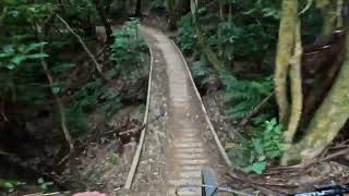
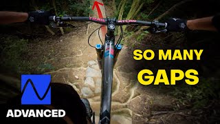
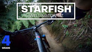
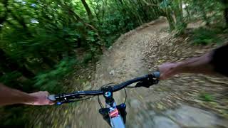
Starfish is a fun, narrow piece of classic Wellington singletrack.

While Starfish isn't very steep, the trail builders have made the most of the terrain by including plenty of features including a rock roll, multiple drops, rollable jumps, a rock garden and a couple of alternative lines.

It's definitely a step up in difficulty from grade 3 trails like Smokin and SWIGG. It's a bit steeper, narrower, rougher and generally more difficult.

Originally built in 1998 with upgrades in 2000 and 2016. A major extension and realignment was hand built by volunteers in 2018/19 creating one long grade 4 trail from Snake Charmer down to the main entrance.

Access Info

You can also drop in from Snakecharmer at the end of Smokin and Miro.

Local Trail Association

Recent Activity on Trail

Past Week
  • 6 rides
  • 13 miles average
6 Months
  • 229 rides
  • 12 miles avg distance
All
  • 2,087 rides
  • Last: Jun 23, 2026
c1c2c3c4
January
February
March
April
May
June
July
August
September
October
November
December
update trails status or condition

Starfish Trail Reports

statusdatedescription
Jun 19, 2026 @ 12:55pm (Pacific/Auckland)
Jun 18, 2026
Mar 10, 2026 @ 5:39pm (Pacific/Auckland)
Mar 9, 2026
Mar 1, 2026 @ 10:51am (Pacific/Auckland)
Feb 28, 2026
Feb 22, 2026 @ 10:29am (Pacific/Auckland)
Feb 21, 2026
Excellent condition, just a little vegetation overgrown here and there.
Feb 10, 2026 @ 12:16pm (Pacific/Auckland)
Feb 9, 2026
reporter A little bit of moisture left in the surface. Corridor is getting a bit narrow in places due to "summer" overgrowth.
more »
Status:
on Jun 19, 2026
Ideal
Avg: 4.47 (32 votes)
Your vote: 0

view (21,530)
close
3D
Trail Conditions
  • Unknown
  • Snow Groomed
  • Snow Packed
  • Snow Covered
  • Snow Cover Partial
  • Freeze/thaw Cycle
  • Icy
  • Prevalent Mud
  • Wet
  • Variable
  • Ideal
  • Dry
  • Very Dry
Trail Flow (Ridden Direction)
Trailforks scans users ridelogs to determine the most popular direction each trail is ridden. A good flowing trail network will have most trails flowing in a single direction according to their intension.
The colour categories are based on what percentage of riders are riding a trail in its intended direction.
  • > 96%
  • > 90%
  • > 80%
  • > 70%
  • > 50%
  • < 50%
  • bi-directional trail
  • no data
Trail Last Ridden
Trailforks scans ridelogs to determine the last time a trail was ridden.
  • < 2 days
  • < 1 week
  • < 2 weeks
  • < 1 month
  • < 6 months
  • > 6 months
Trail Ridden Direction
The intended direction a trail should be ridden.
  • Downhill Only
  • Downhill Primary
  • Both Directions
  • Uphill Primary
  • Uphill Only
  • One Direction
Contribute Details
Colors indicate trail is missing specified detail.
  • Description
  • Photos
  • Description & Photos
  • Videos
Trail Popularity ?
Trailforks scans ridelogs to determine which trails are ridden the most in the last 9 months. Trails are compared with nearby trails in the same city region with a possible 25 colour shades. Think of this as a heatmap, more rides = more kinetic energy = warmer colors.
  • most popular
  • popular
  • less popular
  • not popular
ATV/ORV/OHV Filter
Max Vehicle Width
inches
US Cell Coverage
Legend
cell carrier legend

Radar Time
Activity Recordings
Trailforks uses anonymized public activity data. ?
Activity Recordings
Trailforks uses anonymized public activity data. ?
Personal Heatmap
Activity Types
all / none
Options
2
Date range month
Winter Trails
Warning A routing network for winter maps does not exist. Selecting trails using the winter trails layer has been disabled.
Missing Trails
Most Popular
Least Popular
Trails are colored based on popularity. The more popular a trail is, the more red. Less popular trails trend towards green.
Jump Magnitude Heatmap
Heatmap of where riders jump on trails. Zoom in to see individual jumps, click circles to view jump details.
BC Backroad Status

Service Road Atlas is a free to use, community-driven service for viewing and creating reports on the numerous back-country service roads around B.C. and Alberta.

map legend
Slope Aspect
Direction the slope faces
Flat N NE E SE S SW W NW
Trails Deemphasized
Trails are shown in grey.
disable
Only show trails with no bike usage.
Enable
Suggested Layers
Based on selected activity type

    Save the current map location and zoom level as your default home location whenever this page is loaded.

    Save
        Directions to starfish trailhead (-41.294610, 174.716190)

        Photos

        12 more »
        144 |
        Aug 26, 2020 @ 2:29am
        Aug 26, 2020
        182 |
        Jun 10, 2019 @ 4:33pm
        Jun 10, 2019
        176 |
        Jun 10, 2019 @ 4:33pm
        Jun 10, 2019
        184 |
        Dec 10, 2018 @ 9:16am
        Dec 10, 2018

        Videos

        14 more »
        youtuber Starfish @ Makara Peak MTB Park. Wellington
        3:36 | 290 | Dec 9, 2024 , Wellington
        youtuber Starfish | Makara's Perfect Mix of Tech & Flow
        3:16 | 783 | Feb 27, 2022 , Wellington
        youtuber FEATURE PACKED FUN - Starfish Mountain Bike...
        5:05 | 1016 | Aug 26, 2020 , Wellington
        youtuber Starfish @ Makara Peak Mountain Bike Park
        5:23 | 611 | Jan 19, 2021 , Wellington

        Routes with this trail

        3.8 24 miles 4,609 ft 42 Point to Point
        Starting at the in Johnsonville and finishing in Owhiro Bay. This track is a solid day's undertaking and...
        3.0 8 miles 1,356 ft 14 Loop
        Tired of and looking for an alternative to the usual intermediate or grade 3 lap of Makara Peak? Try...
        35 miles 7,069 ft 32 Loop
        From Johnsonville train station to Underworld Tavern the long way around. This route connects the main...

        4 Reviews & Comments


        We hope you've been enjoying Trailforks!

        Create a FREE account to view trail comments and much more.

        Frequently Asked Questions About Starfish

        Where is Starfish located?
        Starfish is located in Mākara Peak Mountain Bike Park, Wellington, New Zealand. It is part of the Mākara Peak Mountain Bike Park trail network. The trailhead is located at coordinates -41.29461, 174.71619.
        How hard is Starfish?
        Starfish is rated as Advanced difficulty. The physical rating is Moderate. The average grade is 8.6%. The climb difficulty is rated Blue.
        What is the elevation gain for Starfish?
        Starfish has 38 ft of elevation gain. The trail has 363 ft of elevation descent. The elevation ranges from 448 ft to 773 ft.
        Is Starfish a point to point trail?
        Yes, Starfish is a point to point trail. The direction is Downhill Only. The trail type is singletrack.

        Hit the Trail

        Open in App

        Get this trail on your phone instantly.
        open trail in app

        Download Trail

        Save to wishlist, Garmin & download.
        save the trail

        Find Related Routes

        Find routes and users activities that include this trail.
        find routes for this trail

        You must enter a description before submitting.