more stats
320 ft
Distance
-47 ft
Descent
211 ft
High Point
-47 ft
Altitude change
165 ft
Altitude min
211 ft
Altitude start
165 ft
Altitude end
-14.631%
Grade
-14.927%
Grade max
-14.062%
Grade min
320 ft
Distance down

Steetley Woods Details

  • Activities
    • Mountain Bike
    • Hike
    • Trail Running
  • Riding Area
    Nearcliffe Woods
    Doncaster
  • Difficulty Rating
  • Voted Difficulty
    Red (1 vote)
  • Local Popularity
    5 in Mountain Biking [+]
    • 5 in Trail Running
    • 5 in Hiking
  • Global Ranking
    #121294 in Mountain Biking [+]
    • #128194 in Trail Running
    • #121284 in Hiking
  • Trail Type
    Mixed
  • Bike Type
    DH
  • Direction
    Downhill Primary
    Popular Direction Shown
  • Physical Rating
    Moderate
  • Dogs Allowed
    Yes
  • eBike Allowed
    Yes up to Class 1
  • TTFs on Trail
    Drop, Jump
  • Ride in Rain
    Yes
  • Year Opened
    2013

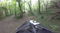
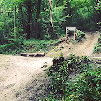
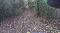
Steetley Woods is located in Conisbrough a town just outside of Doncaster. It has previously held an extreme sports event there. The track contains some big jumps and drops which would require some experience in downhilling to complete. It is a fast track and contains plenty of berms to help you fly round the track.

Access Info

There is an area where you can park your cars or vans on nearby streets but the woods is also accessible by the Pennine trails route and many other paths into the woods.

Recent Activity on Trail

Past Week
  • 0 rides
  •  
6 Months
  • 0 rides
  •  
All
  • 4 rides
  • Last: May 12, 2020
Status:
on Apr 3, 2023
Avg: 4.19 (4 votes)
Your vote: 0

view (59)
close
3D
Trail Conditions
  • Unknown
  • Snow Groomed
  • Snow Packed
  • Snow Covered
  • Snow Cover Partial
  • Freeze/thaw Cycle
  • Icy
  • Prevalent Mud
  • Wet
  • Variable
  • Ideal
  • Dry
  • Very Dry
Trail Flow (Ridden Direction)
Trailforks scans users ridelogs to determine the most popular direction each trail is ridden. A good flowing trail network will have most trails flowing in a single direction according to their intension.
The colour categories are based on what percentage of riders are riding a trail in its intended direction.
  • > 96%
  • > 90%
  • > 80%
  • > 70%
  • > 50%
  • < 50%
  • bi-directional trail
  • no data
Trail Last Ridden
Trailforks scans ridelogs to determine the last time a trail was ridden.
  • < 2 days
  • < 1 week
  • < 2 weeks
  • < 1 month
  • < 6 months
  • > 6 months
Trail Ridden Direction
The intended direction a trail should be ridden.
  • Downhill Only
  • Downhill Primary
  • Both Directions
  • Uphill Primary
  • Uphill Only
  • One Direction
Contribute Details
Colors indicate trail is missing specified detail.
  • Description
  • Photos
  • Description & Photos
  • Videos
Trail Popularity ?
Trailforks scans ridelogs to determine which trails are ridden the most in the last 9 months. Trails are compared with nearby trails in the same city region with a possible 25 colour shades. Think of this as a heatmap, more rides = more kinetic energy = warmer colors.
  • most popular
  • popular
  • less popular
  • not popular
ATV/ORV/OHV Filter
Max Vehicle Width
inches
US Cell Coverage
Legend
cell carrier legend

Radar Time
Activity Recordings
Trailforks uses anonymized public activity data. ?
Activity Recordings
Trailforks uses anonymized public activity data. ?
Personal Heatmap
Activity Types
all / none
Options
2
Date range month
Winter Trails
Warning A routing network for winter maps does not exist. Selecting trails using the winter trails layer has been disabled.
Missing Trails
Most Popular
Least Popular
Trails are colored based on popularity. The more popular a trail is, the more red. Less popular trails trend towards green.
Jump Magnitude Heatmap
Heatmap of where riders jump on trails. Zoom in to see individual jumps, click circles to view jump details.
BC Backroad Status

Service Road Atlas is a free to use, community-driven service for viewing and creating reports on the numerous back-country service roads around B.C. and Alberta.

map legend
Slope Aspect
Direction the slope faces
Flat N NE E SE S SW W NW
Trails Deemphasized
Trails are shown in grey.
disable
Only show trails with no bike usage.
Enable
Suggested Layers
Based on selected activity type

    Save the current map location and zoom level as your default home location whenever this page is loaded.

    Save
        Directions to steetley-woods trailhead (53.485913, -1.209666)

        Photos

        53 more »
        180 |
        Feb 27, 2019 @ 12:13pm
        Feb 27, 2019
        399 |
        Feb 27, 2019 @ 12:14pm
        Feb 27, 2019
        304 |
        Jul 18, 2018 @ 2:34am
        Jul 18, 2018
        139 |
        Jul 9, 2018 @ 4:00am
        Jul 9, 2018

        Videos

        8 more »
        Steely New jumps
        2:49 | 1262 | May 23, 2015 , Doncaster
        Road gap
        0:06 | 1361 | Jan 20, 2015 , Doncaster
        Road gap
        0:28 | 472 | Jan 20, 2015 , Doncaster
        STEETLY MATES RACE
        3:11 | 387 | Oct 19, 2014 , Doncaster

        Reviews / Comments

        No reviews yet, be the first to write a review or ask a question.
        Use trail reports to comment on trail conditions.


        We hope you've been enjoying Trailforks!

        Create a FREE account to view trail comments and much more.

        • By Jacob19 & contributors
        • #8536 - 20,335 views

        Frequently Asked Questions About Steetley Woods

        Where is Steetley Woods located?
        Steetley Woods is located in Nearcliffe Woods, Doncaster, United Kingdom. It is part of the Nearcliffe Woods trail network. The trailhead is located at coordinates 53.48591, -1.20967.
        How hard is Steetley Woods?
        Steetley Woods is rated as Blue difficulty. The physical rating is Moderate. The average grade is 14.631%.
        What is the elevation gain for Steetley Woods?
        The trail has 14 m of elevation descent. The elevation ranges from 50 m to 64 m.
        Is Steetley Woods a point to point trail?
        Steetley Woods is not a point to point trail. The direction is Downhill Primary. The trail type is mixed.

        Hit the Trail

        Open in App

        Get this trail on your phone instantly.
        open trail in app

        Download Trail

        Save to wishlist, Garmin & download.
        save the trail

        Find Related Routes

        Find routes and users activities that include this trail.
        find routes for this trail

        You must enter a description before submitting.