


Open in App
Get this trail on your phone instantly.

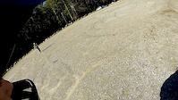
Most of this is too steep to ride on the ascent. Especially closer to the top. A lot of hike-a-bike. But the view at the top is pretty good and the ride down is pretty technical with lots of rocks, ruts and some drops. An open field near the top of the field can get so choked up during the summer that it is impassable, so bring hand clippers if you want to get to the top.
| c1 | c2 | c3 | c4 |
|---|---|---|---|
January | February | March | April |
May | June | July | August |
September | October | November | December |

Service Road Atlas is a free to use, community-driven service for viewing and creating reports on the numerous back-country service roads around B.C. and Alberta.
Save the current map location and zoom level as your default home location whenever this page is loaded.
SaveWe hope you've been enjoying Trailforks!
Create a FREE account to view trail comments and much more.
You must enter a description before submitting.

