more stats
12.0 miles
Distance
770 ft
Climb
-1,186 ft
Descent
01:08:56
Avg time
-416 ft
Altitude change
4,333 ft
Altitude min
4,840 ft
Altitude max
4,749 ft
Altitude start
4,334 ft
Altitude end
-0.7%
Grade
-43.4%
Grade max
32.2%
Grade min
4 miles
Distance climb
6 miles
Distance down
2 miles
Distance flat
01:08:56
Avg time

Stoney Trail Details

  • Activities
    • Mountain Bike
    • Horse
    • Hike
    • Trail Running
  • Riding Area
  • Difficulty Rating
  • Local Popularity
    30 in Mountain Biking [+]
    • 5 in Trail Running
    • 5 in Hiking
    • 5 in Horseback
  • Global Ranking
    #156716 in Mountain Biking [+]
    • #269196 in Trail Running
    • #279324 in Hiking
    • #2696 in Horseback
  • Trail Type
    Mixed
  • Bike Type
    AM, XC, Fat
  • Direction
    Both Directions
  • Climb Difficulty
    Green
  • Physical Rating
    Easy
  • Season
    May - November
  • Dogs Allowed
    Yes
  • eBike Allowed
  • Land Owner

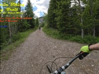
This is a connector trail/road, and not worth doing on its own except for beginners. Lots of hikers and horses on the weekends.

Jewell Pass, Prairie View and the Camp Chief Hector DH can all use this trail to make loops.

Local Trail Association

Recent Activity on Trail

Past Week
  • 0 rides
  •  
6 Months
  • 0 rides
  •  
All
  • 16 rides
  • Last: May 3, 2026
c1c2c3c4
January
February
March
April
May
June
July
August
September
October
November
December
update trails status or condition

Stoney Trail Trail Reports

statusdatedescription
Jun 7, 2026 @ 10:03pm (America/Edmonton)
Jun 7, 2026
Clear of trees between Troll Falls and Barrier Dam Day-use area. Expect to have wet feet, deep puddles and mandatory creek crossings.
May 2, 2026 @ 10:16pm (America/Edmonton)
May 2, 2026
A few trees down to navigate over the descent along the camp Chief Hector boubdary. Nice of dry and muddy sections.
Sep 25, 2025 @ 8:49pm (America/Edmonton)
Sep 25, 2025
Aug 16, 2025 @ 6:35pm
Aug 16, 2025
With all the rain recently we decided to do this route from the Barrier Dam parking lot to get some much needed time in the saddle....dry and...
Sep 24, 2023 @ 8:51am
Sep 24, 2023
more »
Status:
on Jun 7, 2026
Variable
Avg: 2.99 (3 votes)
Your vote: 0

view (33)
close
3D
Trail Conditions
  • Unknown
  • Snow Groomed
  • Snow Packed
  • Snow Covered
  • Snow Cover Partial
  • Freeze/thaw Cycle
  • Icy
  • Prevalent Mud
  • Wet
  • Variable
  • Ideal
  • Dry
  • Very Dry
Trail Flow (Ridden Direction)
Trailforks scans users ridelogs to determine the most popular direction each trail is ridden. A good flowing trail network will have most trails flowing in a single direction according to their intension.
The colour categories are based on what percentage of riders are riding a trail in its intended direction.
  • > 96%
  • > 90%
  • > 80%
  • > 70%
  • > 50%
  • < 50%
  • bi-directional trail
  • no data
Trail Last Ridden
Trailforks scans ridelogs to determine the last time a trail was ridden.
  • < 2 days
  • < 1 week
  • < 2 weeks
  • < 1 month
  • < 6 months
  • > 6 months
Trail Ridden Direction
The intended direction a trail should be ridden.
  • Downhill Only
  • Downhill Primary
  • Both Directions
  • Uphill Primary
  • Uphill Only
  • One Direction
Contribute Details
Colors indicate trail is missing specified detail.
  • Description
  • Photos
  • Description & Photos
  • Videos
Trail Popularity ?
Trailforks scans ridelogs to determine which trails are ridden the most in the last 9 months. Trails are compared with nearby trails in the same city region with a possible 25 colour shades. Think of this as a heatmap, more rides = more kinetic energy = warmer colors.
  • most popular
  • popular
  • less popular
  • not popular
ATV/ORV/OHV Filter
Max Vehicle Width
inches
US Cell Coverage
Legend
cell carrier legend

Radar Time
Activity Recordings
Trailforks uses anonymized public activity data. ?
Activity Recordings
Trailforks uses anonymized public activity data. ?
Personal Heatmap
Activity Types
all / none
Options
2
Date range month
Winter Trails
Warning A routing network for winter maps does not exist. Selecting trails using the winter trails layer has been disabled.
Missing Trails
Most Popular
Least Popular
Trails are colored based on popularity. The more popular a trail is, the more red. Less popular trails trend towards green.
Jump Magnitude Heatmap
Heatmap of where riders jump on trails. Zoom in to see individual jumps, click circles to view jump details.
BC Backroad Status

Service Road Atlas is a free to use, community-driven service for viewing and creating reports on the numerous back-country service roads around B.C. and Alberta.

map legend
Slope Aspect
Direction the slope faces
Flat N NE E SE S SW W NW
Trails Deemphasized
Trails are shown in grey.
disable
Only show trails with no bike usage.
Enable
Suggested Layers
Based on selected activity type

    Save the current map location and zoom level as your default home location whenever this page is loaded.

    Save
        Directions to stoney-trail trailhead (50.936450, -115.141420)

        Photos

        6 more »
        2 |
        Jun 21, 2026 @ 10:00am
        6 hours
        0 |
        Jun 21, 2026 @ 9:59am
        6 hours
        0 |
        Jun 21, 2026 @ 9:59am
        6 hours
        70 |
        May 21, 2025 @ 8:19am
        May 21, 2025

        Videos

        1 more »
        Mountain Biking Stoney Trail - Alberta, Canada...
        8:41 | 1 | Jun 21, 2026 , Canmore

        Routes with this trail

        4.0 9 miles 1,721 ft 5 Loop
        Park at east entrance of Barrier Lake. Take . Connect and go down . At the bottom/end of , connect with...
        5.0 12 miles 3,102 ft 5
        Jewell Pass Prairie View and Razors Edge
        4.0 9 miles 1,534 ft 7 Loop
        Probably the most pleasant way to get around . CCH is a great descent, but the ride back to Barrier Dam...

        2 Reviews & Comments


        We hope you've been enjoying Trailforks!

        Create a FREE account to view trail comments and much more.

        • By pinkrobe & contributors
        • #7996 - 9,018 views

        Frequently Asked Questions About Stoney Trail

        Where is Stoney Trail located?
        Stoney Trail is located in Bow Valley Wildland Provincial Park, Canmore, Alberta, Canada. It is part of the Bow Valley Wildland Provincial Park trail network. The trailhead is located at coordinates 50.93645, -115.14142.
        How hard is Stoney Trail?
        Stoney Trail is rated as Green difficulty. The physical rating is Easy. The average grade is 0.7%. The climb difficulty is rated Green.
        What is the elevation gain for Stoney Trail?
        Stoney Trail has 235 m of elevation gain. The trail has 362 m of elevation descent. The elevation ranges from 1,321 m to 1,475 m.
        Is Stoney Trail a point to point trail?
        Stoney Trail is not a point to point trail. The direction is Both Directions. The trail type is mixed.

        Hit the Trail

        Open in App

        Get this trail on your phone instantly.
        open trail in app

        Download Trail

        Save to wishlist, Garmin & download.
        save the trail

        Find Related Routes

        Find routes and users activities that include this trail.
        find routes for this trail

        You must enter a description before submitting.