more stats
1.3 miles
Distance
21 ft
Climb
-290 ft
Descent
00:07:39
Avg time
-268 ft
Altitude change
7,451 ft
Altitude min
7,723 ft
Altitude max
7,723 ft
Altitude start
7,454 ft
Altitude end
-4.1%
Grade
-18.5%
Grade max
7.4%
Grade min
787 ft
Distance climb
5,220 ft
Distance down
597 ft
Distance flat
00:07:39
Avg time

Stopwatch Trail Details

  • Activities
    • Mountain Bike
    • Hike
    • Trail Running
  • Riding Area
    Bald Mountain Ephraim
    Ephraim, Utah
  • Ref Number
    #5230
  • Difficulty Rating
  • Voted Difficulty
    Green (1 vote)
  • Local Popularity
    95 in Mountain Biking [+]
    • 90 in Trail Running
    • 100 in Hiking
  • Global Ranking
    #71123 in Mountain Biking [+]
    • #47959 in Trail Running
    • #34255 in Hiking
  • Hiking SAC Scale
    T1 Hiking
  • Trail Type
    Singletrack
  • Bike Type
    DH, AM, XC, DJ
  • Direction
    Both Directions
  • Climb Difficulty
    Blue
  • Trail Visibility
    Always easy to follow
  • Family Friendly
    Yes
  • Dogs Allowed
    Yes
  • eBike Allowed
  • TTFs on Trail
    Berm, Jump
  • Land Owner
    manti- la Sal National Forest

Stopwatch Trail
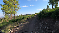
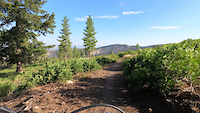
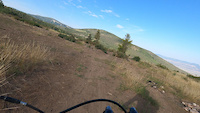
The Stopwatch Trail is a versatile and enjoyable trail, perfect for both mountain biking and trail running. With a fun switchback section through a beautiful ponderosa grove, the trail offers an exciting challenge as you navigate the turns. Along the way, you'll pass through areas of Gambel Oak, adding to the scenic variety. This trail is a great option to ride in either direction, giving you flexibility depending on your starting point. Whether you're cycling or running, the Stopwatch Trail provides a rewarding and scenic experience for outdoor enthusiasts of all kinds.

Recent Activity on Trail

Past Week
  • 2 rides
  • 4 miles average
6 Months
  • 8 rides
  • 7 miles avg distance
All
  • 66 rides
  • Last: Jun 17, 2026
c1c2c3c4
January
February
March
April
May
June
July
August
September
October
November
December
update trails status or condition

Stopwatch Trail Trail Reports

statusdatedescription
Aug 7, 2025 @ 5:52pm
Aug 7, 2025
Dry, but still in good shape
Jun 22, 2025 @ 5:02pm
Jun 22, 2025
May 31, 2024 @ 12:33pm
May 31, 2024
A couple muddy areas from recent snow melt. We were able to get around them ok, but it would be better to wait a little.
Oct 17, 2023 @ 10:39am
Oct 17, 2023
Sep 26, 2023 @ 11:11am
Sep 26, 2023
more »
Status:
on Aug 7, 2025
Dry
Avg: 3.86 (3 votes)
Your vote: 0

view (590)
close
3D
Trail Conditions
  • Unknown
  • Snow Groomed
  • Snow Packed
  • Snow Covered
  • Snow Cover Partial
  • Freeze/thaw Cycle
  • Icy
  • Prevalent Mud
  • Wet
  • Variable
  • Ideal
  • Dry
  • Very Dry
Trail Flow (Ridden Direction)
Trailforks scans users ridelogs to determine the most popular direction each trail is ridden. A good flowing trail network will have most trails flowing in a single direction according to their intension.
The colour categories are based on what percentage of riders are riding a trail in its intended direction.
  • > 96%
  • > 90%
  • > 80%
  • > 70%
  • > 50%
  • < 50%
  • bi-directional trail
  • no data
Trail Last Ridden
Trailforks scans ridelogs to determine the last time a trail was ridden.
  • < 2 days
  • < 1 week
  • < 2 weeks
  • < 1 month
  • < 6 months
  • > 6 months
Trail Ridden Direction
The intended direction a trail should be ridden.
  • Downhill Only
  • Downhill Primary
  • Both Directions
  • Uphill Primary
  • Uphill Only
  • One Direction
Contribute Details
Colors indicate trail is missing specified detail.
  • Description
  • Photos
  • Description & Photos
  • Videos
Trail Popularity ?
Trailforks scans ridelogs to determine which trails are ridden the most in the last 9 months. Trails are compared with nearby trails in the same city region with a possible 25 colour shades. Think of this as a heatmap, more rides = more kinetic energy = warmer colors.
  • most popular
  • popular
  • less popular
  • not popular
ATV/ORV/OHV Filter
Max Vehicle Width
inches
US Cell Coverage
Legend
cell carrier legend

Radar Time
Activity Recordings
Trailforks uses anonymized public activity data. ?
Activity Recordings
Trailforks uses anonymized public activity data. ?
Personal Heatmap
Activity Types
all / none
Options
2
Date range month
Winter Trails
Warning A routing network for winter maps does not exist. Selecting trails using the winter trails layer has been disabled.
Missing Trails
Most Popular
Least Popular
Trails are colored based on popularity. The more popular a trail is, the more red. Less popular trails trend towards green.
Jump Magnitude Heatmap
Heatmap of where riders jump on trails. Zoom in to see individual jumps, click circles to view jump details.
BC Backroad Status

Service Road Atlas is a free to use, community-driven service for viewing and creating reports on the numerous back-country service roads around B.C. and Alberta.

map legend
Slope Aspect
Direction the slope faces
Flat N NE E SE S SW W NW
Trails Deemphasized
Trails are shown in grey.
disable
Only show trails with no bike usage.
Enable
Suggested Layers
Based on selected activity type

    Save the current map location and zoom level as your default home location whenever this page is loaded.

    Save
        Directions to stopwatch-trail trailhead (39.331250, -111.510880)

        Photos

        22 more »
        28 |
        Jul 13, 2025 @ 8:05pm
        Jul 13, 2025
        29 |
        Jul 13, 2025 @ 8:05pm
        Jul 13, 2025
        30 |
        Jul 13, 2025 @ 8:05pm
        Jul 13, 2025
        27 |
        Mar 5, 2025 @ 3:24pm
        Mar 5, 2025

        Videos

        3 more »
        0:29 | 34 | Aug 6, 2022 , Ephraim
        0:39 | 15 | Aug 6, 2022 , Ephraim
        0:41 | 13 | Aug 6, 2022 , Ephraim

        1 Review & Comments


        We hope you've been enjoying Trailforks!

        Create a FREE account to view trail comments and much more.

        • By kylerdaybell & contributors
        • #306036 - 894 views

        Frequently Asked Questions About Stopwatch Trail

        Where is Stopwatch Trail located?
        Stopwatch Trail is located in Bald Mountain Ephraim, Ephraim, Utah, United States. It is part of the Bald Mountain Ephraim trail network. The trailhead is located at coordinates 39.33125, -111.51088.
        How hard is Stopwatch Trail?
        Stopwatch Trail is rated as Green difficulty. The average grade is 4.1%. The climb difficulty is rated Blue.
        What is the elevation gain for Stopwatch Trail?
        Stopwatch Trail has 7 m of elevation gain. The trail has 88 m of elevation descent. The elevation ranges from 2,271 m to 2,354 m.
        Is Stopwatch Trail a point to point trail?
        Stopwatch Trail is not a point to point trail. The direction is Both Directions. The trail type is singletrack.

        Hit the Trail

        Open in App

        Get this trail on your phone instantly.
        open trail in app

        Download Trail

        Save to wishlist, Garmin & download.
        save the trail

        Find Related Routes

        Find routes and users activities that include this trail.
        find routes for this trail

        You must enter a description before submitting.