more stats
1.4 miles
Distance
3 ft
Climb
-527 ft
Descent
00:10:08
Avg time
-524 ft
Altitude change
3,385 ft
Altitude min
3,909 ft
Altitude max
3,909 ft
Altitude start
3,386 ft
Altitude end
-7.1%
Grade
-26.5%
Grade max
3.3%
Grade min
197 ft
Distance climb
1 mile
Distance down
420 ft
Distance flat
00:10:08
Avg time

Stormrider Details

  • Activities
    • Mountain Bike
    • E-Bike
  • Riding Area
    99 Mile Enduro Trails
    100 Mile House, British Columbia
  • Difficulty Rating
  • Local Popularity
    90 in Mountain Biking [+]
    • 80 in E-Biking
  • Global Ranking
    #64863 in Mountain Biking [+]
    • #45384 in E-Biking
  • Trail Type
    Singletrack
  • Bike Type
    DH, AM
  • Direction
    Downhill Only
    Popular Direction Shown
  • eBike Allowed
    Yes up to Class 1
  • TTFs on Trail
    Berm, Bridge, Drop, Jump
  • Land Owner
    BC Parks and Trails

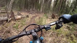
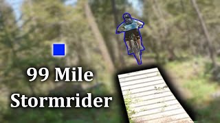
Originally built by the Stormriders fire crew in 2015, including Dr. Nicholas Lubbe, this trail is a downhill only ride with multiple wood jumps and bridges, dirt/rock jumps which are normally found on black trails. It was the first downhill trail in the area. Stormrider Downhill Trail at 99 Mile.

Access Info

See Desription

Disclaimer

Hiking and Moto not allowed!

Local Trail Association
Traditionally Indigenous Territory

Recent Activity on Trail

Past Week
  • 2 rides
  • 8 miles average
6 Months
  • 7 rides
  • 12 miles avg distance
All
  • 120 rides
  • Last: Jun 20, 2026
c1c2c3c4
January
February
March
April
May
June
July
August
September
October
November
December
update trails status or condition

Stormrider Trail Reports

statusdatedescription
Aug 31, 2025 @ 12:16pm
Aug 31, 2025
Aug 3, 2025 @ 9:18am
Aug 3, 2025
Jun 1, 2025 @ 8:12am
Jun 1, 2025
lots of arnica, clematis almost finished, one tree over trail otherwise in good condition; always a great walk
May 17, 2025 @ 8:16pm
May 17, 2025
Uppermost ramp section has been damaged by Spruce tree root ball.
Aug 14, 2024 @ 12:19pm
Aug 14, 2024
fun and flowy
more »
Status:
on Aug 31, 2025
Very Dry
Avg: 4 (11 votes)
Your vote: 0

view (553)
close
3D
Trail Conditions
  • Unknown
  • Snow Groomed
  • Snow Packed
  • Snow Covered
  • Snow Cover Partial
  • Freeze/thaw Cycle
  • Icy
  • Prevalent Mud
  • Wet
  • Variable
  • Ideal
  • Dry
  • Very Dry
Trail Flow (Ridden Direction)
Trailforks scans users ridelogs to determine the most popular direction each trail is ridden. A good flowing trail network will have most trails flowing in a single direction according to their intension.
The colour categories are based on what percentage of riders are riding a trail in its intended direction.
  • > 96%
  • > 90%
  • > 80%
  • > 70%
  • > 50%
  • < 50%
  • bi-directional trail
  • no data
Trail Last Ridden
Trailforks scans ridelogs to determine the last time a trail was ridden.
  • < 2 days
  • < 1 week
  • < 2 weeks
  • < 1 month
  • < 6 months
  • > 6 months
Trail Ridden Direction
The intended direction a trail should be ridden.
  • Downhill Only
  • Downhill Primary
  • Both Directions
  • Uphill Primary
  • Uphill Only
  • One Direction
Contribute Details
Colors indicate trail is missing specified detail.
  • Description
  • Photos
  • Description & Photos
  • Videos
Trail Popularity ?
Trailforks scans ridelogs to determine which trails are ridden the most in the last 9 months. Trails are compared with nearby trails in the same city region with a possible 25 colour shades. Think of this as a heatmap, more rides = more kinetic energy = warmer colors.
  • most popular
  • popular
  • less popular
  • not popular
ATV/ORV/OHV Filter
Max Vehicle Width
inches
US Cell Coverage
Legend
cell carrier legend

Radar Time
Activity Recordings
Trailforks uses anonymized public activity data. ?
Activity Recordings
Trailforks uses anonymized public activity data. ?
Personal Heatmap
Activity Types
all / none
Options
2
Date range month
Winter Trails
Warning A routing network for winter maps does not exist. Selecting trails using the winter trails layer has been disabled.
Missing Trails
Most Popular
Least Popular
Trails are colored based on popularity. The more popular a trail is, the more red. Less popular trails trend towards green.
Jump Magnitude Heatmap
Heatmap of where riders jump on trails. Zoom in to see individual jumps, click circles to view jump details.
BC Backroad Status

Service Road Atlas is a free to use, community-driven service for viewing and creating reports on the numerous back-country service roads around B.C. and Alberta.

map legend
Slope Aspect
Direction the slope faces
Flat N NE E SE S SW W NW
Trails Deemphasized
Trails are shown in grey.
disable
Only show trails with no bike usage.
Enable
Suggested Layers
Based on selected activity type

    Save the current map location and zoom level as your default home location whenever this page is loaded.

    Save
        Directions to stormrider trailhead (51.620100, -121.326330)

        Photos

        22 more »
        68 |
        Jun 26, 2023 @ 5:10pm
        Jun 26, 2023
        65 |
        Jun 26, 2023 @ 5:10pm
        Jun 26, 2023
        69 |
        Jun 26, 2023 @ 5:10pm
        Jun 26, 2023
        111 |
        Jul 1, 2022 @ 6:39pm
        Jul 1, 2022

        Videos

        3 more »
        Stormrider at 99 mile
        6:06 | 171 | May 6, 2024 , 100 Mile House
        A Hand Built Flow Trail | Stormrider - 99 Mile
        7:23 | 382 | Jul 8, 2023 , 100 Mile House
        Stormrider
        0:13 | 425 | May 14, 2019 , 100 Mile House

        2 Reviews & Comments


        We hope you've been enjoying Trailforks!

        Create a FREE account to view trail comments and much more.

        • By cariboorectech & contributors
        • #76833 - 4,939 views

        Frequently Asked Questions About Stormrider

        Where is Stormrider located?
        Stormrider is located in 99 Mile Enduro Trails, 100 Mile House, British Columbia, Canada. It is part of the 99 Mile Enduro Trails trail network. The trailhead is located at coordinates 51.6201, -121.32633.
        How hard is Stormrider?
        Stormrider is rated as Blue difficulty. The average grade is 7.1%.
        What is the elevation gain for Stormrider?
        Stormrider has 1 m of elevation gain. The trail has 161 m of elevation descent. The elevation ranges from 1,032 m to 1,192 m.
        Is Stormrider a point to point trail?
        Yes, Stormrider is a point to point trail. The direction is Downhill Only. The trail type is singletrack.

        Hit the Trail

        Open in App

        Get this trail on your phone instantly.
        open trail in app

        Download Trail

        Save to wishlist, Garmin & download.
        save the trail

        Find Related Routes

        Find routes and users activities that include this trail.
        find routes for this trail

        You must enter a description before submitting.