more stats
2.9 miles
Distance
403 ft
Climb
-708 ft
Descent
00:22:32
Avg time
-305 ft
Altitude change
5,881 ft
Altitude min
6,481 ft
Altitude max
6,424 ft
Altitude start
6,119 ft
Altitude end
-2%
Grade
-33.3%
Grade max
30.2%
Grade min
1 mile
Distance climb
2 miles
Distance down
705 ft
Distance flat
00:22:32
Avg time

Stout Details

  • Activities
    • Mountain Bike
    • Hike
    • Trail Running
  • Riding Area
    Horsetooth Mountain
    Fort Collins, Colorado
  • Difficulty Rating
  • Voted Difficulty
    Black Diamond (2 votes)
  • Local Popularity
    75 in Mountain Biking [+]
    • 60 in Trail Running
    • 55 in Hiking
  • Global Ranking
    #74256 in Mountain Biking [+]
    • #98798 in Trail Running
    • #102498 in Hiking
  • Trail Type
    Singletrack
  • Bike Type
    AM, XC
  • Direction
    Both Directions
  • Climb Difficulty
    Black Diamond
  • Trail Visibility
    Always easy to follow
  • Dogs Allowed
    Yes

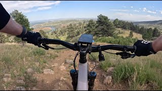
Herrington to Spring Creek - downhill strongly recommended. Chunky and quite loose when dry, with wide open views. Heads up

Spring Creek to Sawmill - much mellower (more like blue) with some great flowy sections and a few punchy tech features. This section rides well either direction. Watch for rattlesnakes.

Local Trail Association

Recent Activity on Trail

Past Week
  • 0 rides
  •  
6 Months
  • 15 rides
  • 10 miles avg distance
All
  • 182 rides
  • Last: Jun 14, 2026
c1c2c3c4
January
February
March
April
May
June
July
August
September
October
November
December
update trails status or condition

Stout Trail Reports

statusdatedescription
Oct 18, 2023 @ 9:42pm
Oct 18, 2023
Dry and blown out. Lots of loose rubble. Very fun!
Jun 30, 2023 @ 9:50pm
Jun 30, 2023
Mar 2, 2023 @ 1:50pm
Mar 2, 2023
Dry on the ridge, snow covered in the trees and in the drainages, lost of frozen mud on the climbs out of the drainages.
Jan 1, 2023 @ 1:00am
Jan 1, 2023
Mix of snow, ice, slush, mud, and dirt
Apr 21, 2022 @ 5:56pm
Apr 21, 2022
ultra dry! go get some
more » 7 social media mentions
Status:
on Oct 18, 2023
Dry
Avg: 3.64 (11 votes)
Your vote: 0

view (1,185)
close
3D
Trail Conditions
  • Unknown
  • Snow Groomed
  • Snow Packed
  • Snow Covered
  • Snow Cover Partial
  • Freeze/thaw Cycle
  • Icy
  • Prevalent Mud
  • Wet
  • Variable
  • Ideal
  • Dry
  • Very Dry
Trail Flow (Ridden Direction)
Trailforks scans users ridelogs to determine the most popular direction each trail is ridden. A good flowing trail network will have most trails flowing in a single direction according to their intension.
The colour categories are based on what percentage of riders are riding a trail in its intended direction.
  • > 96%
  • > 90%
  • > 80%
  • > 70%
  • > 50%
  • < 50%
  • bi-directional trail
  • no data
Trail Last Ridden
Trailforks scans ridelogs to determine the last time a trail was ridden.
  • < 2 days
  • < 1 week
  • < 2 weeks
  • < 1 month
  • < 6 months
  • > 6 months
Trail Ridden Direction
The intended direction a trail should be ridden.
  • Downhill Only
  • Downhill Primary
  • Both Directions
  • Uphill Primary
  • Uphill Only
  • One Direction
Contribute Details
Colors indicate trail is missing specified detail.
  • Description
  • Photos
  • Description & Photos
  • Videos
Trail Popularity ?
Trailforks scans ridelogs to determine which trails are ridden the most in the last 9 months. Trails are compared with nearby trails in the same city region with a possible 25 colour shades. Think of this as a heatmap, more rides = more kinetic energy = warmer colors.
  • most popular
  • popular
  • less popular
  • not popular
ATV/ORV/OHV Filter
Max Vehicle Width
inches
US Cell Coverage
Legend
cell carrier legend

Radar Time
Activity Recordings
Trailforks uses anonymized public activity data. ?
Activity Recordings
Trailforks uses anonymized public activity data. ?
Personal Heatmap
Activity Types
all / none
Options
2
Date range month
Winter Trails
Warning A routing network for winter maps does not exist. Selecting trails using the winter trails layer has been disabled.
Missing Trails
Most Popular
Least Popular
Trails are colored based on popularity. The more popular a trail is, the more red. Less popular trails trend towards green.
Jump Magnitude Heatmap
Heatmap of where riders jump on trails. Zoom in to see individual jumps, click circles to view jump details.
BC Backroad Status

Service Road Atlas is a free to use, community-driven service for viewing and creating reports on the numerous back-country service roads around B.C. and Alberta.

map legend
Slope Aspect
Direction the slope faces
Flat N NE E SE S SW W NW
Trails Deemphasized
Trails are shown in grey.
disable
Only show trails with no bike usage.
Enable
Suggested Layers
Based on selected activity type

    Save the current map location and zoom level as your default home location whenever this page is loaded.

    Save
        Directions to stout trailhead (40.540590, -105.180990)

        Photos

        30 more »
        813 |
        Aug 22, 2018 @ 5:40pm
        Aug 22, 2018
        423 |
        Sep 24, 2014 @ 6:05pm
        Sep 24, 2014
        42 |
        Jul 18, 2025 @ 11:16am
        Jul 18, 2025
        33 |
        Jul 18, 2025 @ 11:08am
        Jul 18, 2025

        Videos

        1 more »
        Stout - Loose! - air down for this one -...
        10:03 | 146 | Jun 30, 2024 , Fort Collins

        Routes with this trail

        8 miles 1,470 ft 6 Loop
        If Maxwell is too short for you or you're just getting bit tired of it, this is your next step up....
        9 miles 1,773 ft 22 Loop
        Crosscountry loop in HTMP taking in some techy climbing. This loop rolls out for a warmup across before...

        Trail Products

        4 Reviews & Comments


        We hope you've been enjoying Trailforks!

        Create a FREE account to view trail comments and much more.

        • By toddTF Pro Trailforks & contributors
        • #13602 - 3,265 views

        Frequently Asked Questions About Stout

        Where is Stout located?
        Stout is located in Horsetooth Mountain, Fort Collins, Colorado, United States. It is part of the Horsetooth Mountain trail network. The trailhead is located at coordinates 40.54059, -105.18099.
        How hard is Stout?
        Stout is rated as Black Diamond difficulty. The average grade is 2%. The climb difficulty is rated Black Diamond.
        What is the elevation gain for Stout?
        Stout has 403 ft of elevation gain. The trail has 708 ft of elevation descent. The elevation ranges from 5,881 ft to 6,481 ft.
        Is Stout a point to point trail?
        Stout is not a point to point trail. The direction is Both Directions. The trail type is singletrack.

        Hit the Trail

        Open in App

        Get this trail on your phone instantly.
        open trail in app

        Download Trail

        Save to wishlist, Garmin & download.
        save the trail

        Find Related Routes

        Find routes and users activities that include this trail.
        find routes for this trail

        You must enter a description before submitting.