more stats
3.3 miles
Distance
917 ft
Climb
-475 ft
Descent
00:55:46
Avg time
440 ft
Altitude change
4,478 ft
Altitude min
5,264 ft
Altitude max
4,478 ft
Altitude start
4,918 ft
Altitude end
2.5%
Grade
-56.7%
Grade max
48.8%
Grade min
2 miles
Distance climb
1 mile
Distance down
1,250 ft
Distance flat
00:55:46
Avg time

Strawberry Peak Details

  • Activities
    • Mountain Bike
    • Hike
    • Trail Running
  • Riding Area
    Angeles National Forest
    Pasadena, California
  • AKA
    Colby Canyon
  • Difficulty Rating
  • Local Popularity
    90 in Mountain Biking [+]
    • 95 in Trail Running
    • 80 in Hiking
  • Global Ranking
    #65284 in Mountain Biking [+]
    • #27999 in Trail Running
    • #76960 in Hiking
  • Hiking SAC Scale
    T2 Mountain Hiking
  • Trail Type
    Singletrack
  • Bike Type
    AM, XC
  • Direction
    Both Directions
    Popular Direction Shown
  • Climb Difficulty
    Blue
  • Physical Rating
    Moderate
  • Trail Visibility
    Always easy to follow
  • Dogs Allowed
    Yes
  • eBike Allowed
  • Land Owner
    Angeles National Forest

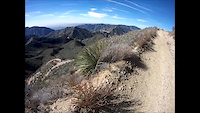
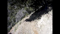
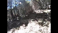
This section of Strawberry Peak Trail starts just east of Strawberry Potrero (meadow) by climbing a series of switchbacks. It then traverses across the eastern slopes of Strawberry Peak while climbing 800ft in two miles to Lawlor Saddle. This part has some technical and sandy sections in addition to exposure that can make for a tough climb. After the saddle, the trail descends 400ft in 1.3 miles to the Old Barley Flats truck trail and on to Red Box TH. This section has exposure but is very rideable both directions.

Trail Supporters

  • USFS
    Land Manager
Local Trail Association
Traditionally Indigenous Territory

Recent Activity on Trail

Past Week
  • 1 rides
  • 17 miles average
6 Months
  • 11 rides
  • 27 miles avg distance
All
  • 77 rides
  • Last: Jun 13, 2026
c1c2c3c4
January
February
March
April
May
June
July
August
September
October
November
December
update trails status or condition

Strawberry Peak Trail Reports

statusdatedescription
Jun 1, 2026 @ 1:27am (America/Los_Angeles)
Jun 1, 2026
Rode it today and it was looking great. No downed trees and no significant ruts
Jan 14, 2026 @ 11:25pm (America/Los_Angeles)
Jan 14, 2026
Rode 1/12/26. Trail from Red Box to saddle is in good shape, one tree down near the saddle. Beyond that trail is in good shape til the...
May 26, 2025 @ 2:47pm
May 26, 2025
Rode it 5/16. Yeah the first sluff/sutter wall section is a bit sketchy but not terrible. On the backside just before dropping into the meadow...
Dec 28, 2024 @ 8:32am
Dec 28, 2024
Lots of brush making the tread narrower than usual, plus a few landslide areas where there isn’t much trail at all, plus one which is really...
Oct 13, 2024 @ 1:40pm
Oct 13, 2024
Minor brush that is passable but I would wear a full face and eye protection. Also there are a few washout spots with exposure that you may want...
more »
Status:
on Jun 1, 2026
Dry
Avg: 4.19 (4 votes)
Your vote: 0

view (633)
close
3D
Trail Conditions
  • Unknown
  • Snow Groomed
  • Snow Packed
  • Snow Covered
  • Snow Cover Partial
  • Freeze/thaw Cycle
  • Icy
  • Prevalent Mud
  • Wet
  • Variable
  • Ideal
  • Dry
  • Very Dry
Trail Flow (Ridden Direction)
Trailforks scans users ridelogs to determine the most popular direction each trail is ridden. A good flowing trail network will have most trails flowing in a single direction according to their intension.
The colour categories are based on what percentage of riders are riding a trail in its intended direction.
  • > 96%
  • > 90%
  • > 80%
  • > 70%
  • > 50%
  • < 50%
  • bi-directional trail
  • no data
Trail Last Ridden
Trailforks scans ridelogs to determine the last time a trail was ridden.
  • < 2 days
  • < 1 week
  • < 2 weeks
  • < 1 month
  • < 6 months
  • > 6 months
Trail Ridden Direction
The intended direction a trail should be ridden.
  • Downhill Only
  • Downhill Primary
  • Both Directions
  • Uphill Primary
  • Uphill Only
  • One Direction
Contribute Details
Colors indicate trail is missing specified detail.
  • Description
  • Photos
  • Description & Photos
  • Videos
Trail Popularity ?
Trailforks scans ridelogs to determine which trails are ridden the most in the last 9 months. Trails are compared with nearby trails in the same city region with a possible 25 colour shades. Think of this as a heatmap, more rides = more kinetic energy = warmer colors.
  • most popular
  • popular
  • less popular
  • not popular
ATV/ORV/OHV Filter
Max Vehicle Width
inches
US Cell Coverage
Legend
cell carrier legend

Radar Time
Activity Recordings
Trailforks uses anonymized public activity data. ?
Activity Recordings
Trailforks uses anonymized public activity data. ?
Personal Heatmap
Activity Types
all / none
Options
2
Date range month
Winter Trails
Warning A routing network for winter maps does not exist. Selecting trails using the winter trails layer has been disabled.
Missing Trails
Most Popular
Least Popular
Trails are colored based on popularity. The more popular a trail is, the more red. Less popular trails trend towards green.
Jump Magnitude Heatmap
Heatmap of where riders jump on trails. Zoom in to see individual jumps, click circles to view jump details.
BC Backroad Status

Service Road Atlas is a free to use, community-driven service for viewing and creating reports on the numerous back-country service roads around B.C. and Alberta.

map legend
Slope Aspect
Direction the slope faces
Flat N NE E SE S SW W NW
Trails Deemphasized
Trails are shown in grey.
disable
Only show trails with no bike usage.
Enable
Suggested Layers
Based on selected activity type

    Save the current map location and zoom level as your default home location whenever this page is loaded.

    Save
        Directions to strawberry-peak trailhead (34.290700, -118.107770)

        Photos

        23 more »
        103 |
        Feb 18, 2021 @ 10:57pm
        Feb 18, 2021
        87 |
        Feb 18, 2021 @ 10:56pm
        Feb 18, 2021
        74 |
        Feb 18, 2021 @ 10:56pm
        Feb 18, 2021
        73 |
        Feb 18, 2021 @ 10:56pm
        Feb 18, 2021

        Videos

        6 more »
        Lollipop XC Loop Part 1: Strawberry Peak | Los...
        58:45 | 349 | Dec 16, 2021 , Pasadena
        Strawberry Peak 2-13-2016
        6:49 | 367 | Feb 13, 2016 , Pasadena
        DG Cat Litter 6-21-2014
        0:48 | 219 | Jun 21, 2014 , Pasadena
        Hard Rockin' 6-21-2014
        0:52 | 241 | Jun 21, 2014 , Pasadena

        Routes with this trail

        5.0 10 miles 2,773 ft 5 Shuttled
        This is the complete Strawberry Peak Route going from the ranger station to red box parking lot.
        223 miles 25,120 ft 12 Loop
        Welcome to the Trans San Gabriel, Californias hardest race! WARNING This event is not for everyone, this...
        220 miles 25,237 ft 12 Loop
        Welcome to the Trans San Gabriel, Californias hardest race! WARNING This event is not for everyone, this...

        3 Reviews & Comments


        We hope you've been enjoying Trailforks!

        Create a FREE account to view trail comments and much more.

        • By BlazeNawaY & contributors
        • #36018 - 4,664 views

        Frequently Asked Questions About Strawberry Peak

        Where is Strawberry Peak located?
        Strawberry Peak is located in Angeles National Forest, Pasadena, California, United States. It is part of the Angeles National Forest trail network. The trailhead is located at coordinates 34.2907, -118.10777.
        How hard is Strawberry Peak?
        Strawberry Peak is rated as Black Diamond difficulty. The physical rating is Moderate. The average grade is 2.5%. The climb difficulty is rated Blue.
        What is the elevation gain for Strawberry Peak?
        Strawberry Peak has 917 ft of elevation gain. The trail has 475 ft of elevation descent. The elevation ranges from 4,478 ft to 5,264 ft.
        Is Strawberry Peak a point to point trail?
        Strawberry Peak is not a point to point trail. The direction is Both Directions. The trail type is singletrack.

        Hit the Trail

        Open in App

        Get this trail on your phone instantly.
        open trail in app

        Download Trail

        Save to wishlist, Garmin & download.
        save the trail

        Find Related Routes

        Find routes and users activities that include this trail.
        find routes for this trail

        You must enter a description before submitting.