more stats
4,551 ft
Distance
8 ft
Climb
-558 ft
Descent
00:09:26
Avg time
-552 ft
Altitude change
494 ft
Altitude min
1,046 ft
Altitude max
1,046 ft
Altitude start
495 ft
Altitude end
-12.1%
Grade
-52.7%
Grade max
11.7%
Grade min
138 ft
Distance climb
4,216 ft
Distance down
194 ft
Distance flat
00:09:26
Avg time

Strommasten-Downhill Details

  • Activities
    • Mountain Bike
  • Riding Area
  • AKA
    SMDH
  • Difficulty Rating
  • Voted Difficulty
    Red (7 votes)
  • Local Popularity
    100 in Mountain Biking
  • Global Ranking
    #14293 in Mountain Biking
  • Trail Type
    Mixed
  • Bike Type
    DH, AM
  • Direction
    Downhill Only
    Popular Direction Shown
  • Physical Rating
    Moderate
  • Dogs Allowed
    Yes
  • TTFs on Trail
    Berm, Drop, Jump, Gap Jump, Ladder Bridge, Rock Garden
  • Year Opened
    2016

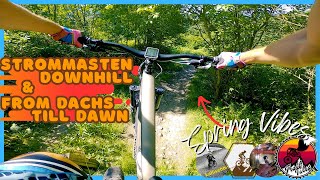
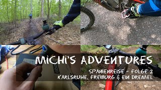
Der erste legale Trail auf dem Weg zu legalen Trails in der Region

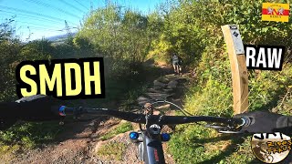
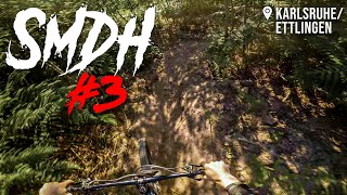
Grundsätzlich sind Umfahrungen für alle Hindernisse, Sprünge und Drops vorhanden. Aufgrund des Gefälles ist aber eine sichere Bikebeherrschung erforderlich. Es herrscht absolute Helmpflicht
Protektoren (Knie/Ellenbogen) sind dringend empfohlen.

Die Strecke wird vom MTB-Club Karlsruhe betrieben. Die Befahrung ist kostenlos und für alle Radfahrer erlaubt. Eine Spende oder Clubmitgliedschaft ist sehr wünschenswert, wenn euch die Strecke gefällt oder ihr regelmäßig fahrt. Wir investieren die Spenden in den Erhalt UND VOR ALLEM in die Schaffung weiterer legaler Trails!

Access Info

Hinterm Wildschweingehege und unter den Hochspannungsleitungen geht es los...

Trail Supporters
  • MTB-Club Karlsruhe
    since 2015
    Builder
Local Trail Association

Recent Activity on Trail

Past Week
  • 0 rides
  •  
6 Months
  • 24 rides
  • 24.7 km avg distance
All
  • 211 rides
  • Last: Jun 20, 2026
c1c2c3c4
January
February
March
April
May
June
July
August
September
October
November
December
update trails status or condition

Strommasten-Downhill Trail Reports

Status:
on May 4, 2026
Variable
Avg: 4.5 (25 votes)
Your vote: 0

view (1,794)
close
3D
Trail Conditions
  • Unknown
  • Snow Groomed
  • Snow Packed
  • Snow Covered
  • Snow Cover Partial
  • Freeze/thaw Cycle
  • Icy
  • Prevalent Mud
  • Wet
  • Variable
  • Ideal
  • Dry
  • Very Dry
Trail Flow (Ridden Direction)
Trailforks scans users ridelogs to determine the most popular direction each trail is ridden. A good flowing trail network will have most trails flowing in a single direction according to their intension.
The colour categories are based on what percentage of riders are riding a trail in its intended direction.
  • > 96%
  • > 90%
  • > 80%
  • > 70%
  • > 50%
  • < 50%
  • bi-directional trail
  • no data
Trail Last Ridden
Trailforks scans ridelogs to determine the last time a trail was ridden.
  • < 2 days
  • < 1 week
  • < 2 weeks
  • < 1 month
  • < 6 months
  • > 6 months
Trail Ridden Direction
The intended direction a trail should be ridden.
  • Downhill Only
  • Downhill Primary
  • Both Directions
  • Uphill Primary
  • Uphill Only
  • One Direction
Contribute Details
Colors indicate trail is missing specified detail.
  • Description
  • Photos
  • Description & Photos
  • Videos
Trail Popularity ?
Trailforks scans ridelogs to determine which trails are ridden the most in the last 9 months. Trails are compared with nearby trails in the same city region with a possible 25 colour shades. Think of this as a heatmap, more rides = more kinetic energy = warmer colors.
  • most popular
  • popular
  • less popular
  • not popular
ATV/ORV/OHV Filter
Max Vehicle Width
inches
US Cell Coverage
Legend
cell carrier legend

Radar Time
Activity Recordings
Trailforks uses anonymized public activity data. ?
Activity Recordings
Trailforks uses anonymized public activity data. ?
Personal Heatmap
Activity Types
all / none
Options
2
Date range month
Winter Trails
Warning A routing network for winter maps does not exist. Selecting trails using the winter trails layer has been disabled.
Missing Trails
Most Popular
Least Popular
Trails are colored based on popularity. The more popular a trail is, the more red. Less popular trails trend towards green.
Jump Magnitude Heatmap
Heatmap of where riders jump on trails. Zoom in to see individual jumps, click circles to view jump details.
BC Backroad Status

Service Road Atlas is a free to use, community-driven service for viewing and creating reports on the numerous back-country service roads around B.C. and Alberta.

map legend
Slope Aspect
Direction the slope faces
Flat N NE E SE S SW W NW
Trails Deemphasized
Trails are shown in grey.
disable
Only show trails with no bike usage.
Enable
Suggested Layers
Based on selected activity type

    Save the current map location and zoom level as your default home location whenever this page is loaded.

    Save
        Directions to strommastendownhill trailhead (48.954820, 8.443650)

        Photos

        71 more »
        90 |
        Jun 11, 2024 @ 12:39pm
        Jun 11, 2024
        102 |
        Jun 5, 2024 @ 11:08am
        Jun 5, 2024
        489 |
        May 8, 2021 @ 1:41pm
        May 8, 2021
        516 |
        Feb 9, 2020 @ 2:31am
        Feb 9, 2020

        Videos

        8 more »
        youtuber Strommasten DH un From Dachs till Dawn //...
        9:47 | 236 | May 19, 2024 , Karlsruhe
        youtuber KARLSRUHE Strommasten-Downhill  Full RAW /...
        5:32 | 131 | Nov 15, 2024 , Karlsruhe
        Karlsruhe, Freiburg & ein Dremel -...
        18:56 | 252 | Sep 12, 2022 , Karlsruhe
        youtuber SMDH Strommastendownhill #3 2020 | Karlsruhe /...
        1189 | Jun 2, 2020 , Karlsruhe

        Reviews / Comments

        No reviews yet, be the first to write a review or ask a question.
        Use trail reports to comment on trail conditions.


        We hope you've been enjoying Trailforks!

        Create a FREE account to view trail comments and much more.

        Frequently Asked Questions About Strommasten-Downhill

        Where is Strommasten-Downhill located?
        Strommasten-Downhill is located in Karlsruhe, Germany. It is part of the Karlsruhe trail network. The trailhead is located at coordinates 48.95482, 8.44365.
        How hard is Strommasten-Downhill?
        Strommasten-Downhill is rated as Red difficulty. The physical rating is Moderate. The average grade is 12.1%.
        What is the elevation gain for Strommasten-Downhill?
        Strommasten-Downhill has 3 m of elevation gain. The trail has 170 m of elevation descent. The elevation ranges from 151 m to 319 m.
        Is Strommasten-Downhill a point to point trail?
        Yes, Strommasten-Downhill is a point to point trail. The direction is Downhill Only. The trail type is mixed.

        Hit the Trail

        Open in App

        Get this trail on your phone instantly.
        open trail in app

        Download Trail

        Save to wishlist, Garmin & download.
        save the trail

        Find Related Routes

        Find routes and users activities that include this trail.
        find routes for this trail

        You must enter a description before submitting.