more stats
3.5 miles
Distance
-1,963 ft
Descent
00:27:09
Avg time
-1,963 ft
Altitude change
5,074 ft
Altitude min
7,037 ft
Altitude max
7,037 ft
Altitude start
5,075 ft
Altitude end
-10.7%
Grade
-52.5%
Grade max
1.9%
Grade min
46 ft
Distance climb
3 miles
Distance down
62 ft
Distance flat
00:27:09
Avg time

Stuart Peak Details

  • Activities
    • Mountain Bike
    • Winter Fat Bike
    • Horse
    • Hike
    • Trail Running
    • Snowshoe
    • Backcountry Ski
  • Riding Area
    The Rattlesnake
    Missoula, Montana
  • Ref Number
    #517
  • Difficulty Rating
  • Local Popularity
    70 in Mountain Biking [+]
    • 50 in Trail Running
    • 60 in Hiking
    • 5 in Horseback
    • 100 in Snowshoeing
    • 5 in Backcountry Skiing
  • Global Ranking
    #85618 in Mountain Biking [+]
    • #107335 in Trail Running
    • #107874 in Hiking
    • #1710 in Snowshoeing
  • Hiking SAC Scale
    T2 Mountain Hiking
  • Trail Type
    Singletrack
  • Bike Type
    AM, XC, Fat
  • Direction
    Both Directions
  • Climb Difficulty
    Black Diamond
  • Physical Rating
    Hard
  • Trail Visibility
    Always easy to follow
  • Season
    June - October
  • Dogs Allowed
    Yes
  • eBike Allowed
  • Land Owner
    USFS

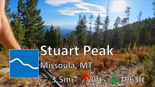
2000 vert of non-stop, fast descending. Pretty smooth the entire way, with only a few small roots. A few switchbacks up top open up to some fast parts through the woods at the bottom. Keep rolling into Spring Gulch for one of the longest non-stop descents you'll find anywhere.

Watch out for hikers Especially on the weekends. Later in the season this trail is also used by hunters heading out to the back country. DO NOT ride beyond the Rattlesnake Wilderness Boundary.

Access Info

While descending down Spring Gulch, take the first sharp left and climb. Climb to the Wilderness boundary then either turn around, or leave your bike and hike to the peak.

Trail Supporters

  • USFS
    Land Manager
Local Trail Association
Traditionally Indigenous Territory

Recent Activity on Trail

Past Week
  • 0 rides
  •  
6 Months
  • 0 rides
  •  
All
  • 46 rides
  • Last: Jun 6, 2026
c1c2c3c4
January
February
March
April
May
June
July
August
September
October
November
December
update trails status or condition

Stuart Peak Trail Reports

statusdatedescription
May 29, 2026 @ 1:39pm (America/Denver)
May 29, 2026
2/3 downed trees at beginning of the trail
May 29, 2026 @ 1:37pm (America/Denver)
May 29, 2026
3/3 downed tree
May 29, 2026 @ 1:26pm (America/Denver)
May 29, 2026
down tree at bottom of trail
Nov 11, 2025 @ 10:18am (America/Denver)
Nov 11, 2025
Mostly clear and rideable to the Wilderness boundary. There is some patches of snow near the top and then the trail is snow covered but packed...
Oct 22, 2025 @ 10:51am (America/Denver)
Oct 22, 2025
Patchy snow but rideable above the culvert to around 6600 feet. Had to push above that. Very slushy on the way back down. Three trees down...
more »
Status:
on May 29, 2026
Dry
Avg: 4.16 (6 votes)
Your vote: 0

view (660)
close
3D
Trail Conditions
  • Unknown
  • Snow Groomed
  • Snow Packed
  • Snow Covered
  • Snow Cover Partial
  • Freeze/thaw Cycle
  • Icy
  • Prevalent Mud
  • Wet
  • Variable
  • Ideal
  • Dry
  • Very Dry
Trail Flow (Ridden Direction)
Trailforks scans users ridelogs to determine the most popular direction each trail is ridden. A good flowing trail network will have most trails flowing in a single direction according to their intension.
The colour categories are based on what percentage of riders are riding a trail in its intended direction.
  • > 96%
  • > 90%
  • > 80%
  • > 70%
  • > 50%
  • < 50%
  • bi-directional trail
  • no data
Trail Last Ridden
Trailforks scans ridelogs to determine the last time a trail was ridden.
  • < 2 days
  • < 1 week
  • < 2 weeks
  • < 1 month
  • < 6 months
  • > 6 months
Trail Ridden Direction
The intended direction a trail should be ridden.
  • Downhill Only
  • Downhill Primary
  • Both Directions
  • Uphill Primary
  • Uphill Only
  • One Direction
Contribute Details
Colors indicate trail is missing specified detail.
  • Description
  • Photos
  • Description & Photos
  • Videos
Trail Popularity ?
Trailforks scans ridelogs to determine which trails are ridden the most in the last 9 months. Trails are compared with nearby trails in the same city region with a possible 25 colour shades. Think of this as a heatmap, more rides = more kinetic energy = warmer colors.
  • most popular
  • popular
  • less popular
  • not popular
ATV/ORV/OHV Filter
Max Vehicle Width
inches
US Cell Coverage
Legend
cell carrier legend

Radar Time
Activity Recordings
Trailforks uses anonymized public activity data. ?
Activity Recordings
Trailforks uses anonymized public activity data. ?
Personal Heatmap
Activity Types
all / none
Options
2
Date range month
Winter Trails
Warning A routing network for winter maps does not exist. Selecting trails using the winter trails layer has been disabled.
Missing Trails
Most Popular
Least Popular
Trails are colored based on popularity. The more popular a trail is, the more red. Less popular trails trend towards green.
Jump Magnitude Heatmap
Heatmap of where riders jump on trails. Zoom in to see individual jumps, click circles to view jump details.
BC Backroad Status

Service Road Atlas is a free to use, community-driven service for viewing and creating reports on the numerous back-country service roads around B.C. and Alberta.

map legend
Slope Aspect
Direction the slope faces
Flat N NE E SE S SW W NW
Trails Deemphasized
Trails are shown in grey.
disable
Only show trails with no bike usage.
Enable
Suggested Layers
Based on selected activity type

    Save the current map location and zoom level as your default home location whenever this page is loaded.

    Save
        Directions to stuart-peak trailhead (46.994170, -113.936460)

        Photos

        11 more »
        478 |
        Sep 26, 2017 @ 3:58pm
        Sep 26, 2017
        308 |
        Sep 26, 2017 @ 3:57pm
        Sep 26, 2017
        29 |
        Jul 6, 2024 @ 4:06pm
        Jul 6, 2024
        170 |
        Oct 18, 2018 @ 8:32pm
        Oct 18, 2018

        Videos

        2 more »
        youtuber Stuart Peak - The Rattlesnake - Missoula, MT
        13:49 | 227 | Sep 27, 2022 , Missoula
        Montana Part 2 Missoula Mountain Biking
        30:55 | 470 | Oct 14, 2020 , Missoula

        Routes with this trail

        27 miles 5,477 ft 8
        The Trail of Pain and woe
        24 miles 5,189 ft 13
        good ride, views, hucks, beargrass

        2 Reviews & Comments


        We hope you've been enjoying Trailforks!

        Create a FREE account to view trail comments and much more.

        • By lukeanders83TF Pro & contributors
        • #25549 - 6,302 views

        Frequently Asked Questions About Stuart Peak

        Where is Stuart Peak located?
        Stuart Peak is located in The Rattlesnake, Missoula, Montana, United States. It is part of the The Rattlesnake trail network. The trailhead is located at coordinates 46.99417, -113.93646.
        How hard is Stuart Peak?
        Stuart Peak is rated as Blue difficulty. The physical rating is Hard. The average grade is 10.7%. The climb difficulty is rated Black Diamond.
        What is the elevation gain for Stuart Peak?
        The trail has 1,963 ft of elevation descent. The elevation ranges from 5,074 ft to 7,037 ft.
        Is Stuart Peak a point to point trail?
        Stuart Peak is not a point to point trail. The direction is Both Directions. The trail type is singletrack.

        Hit the Trail

        Open in App

        Get this trail on your phone instantly.
        open trail in app

        Download Trail

        Save to wishlist, Garmin & download.
        save the trail

        Find Related Routes

        Find routes and users activities that include this trail.
        find routes for this trail

        You must enter a description before submitting.