

Open in App
Get this trail on your phone instantly.

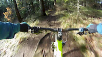
Schöner natürlicher Trail. Im ersten Teil breit und sehr schnell, nach dem Rappeneck kommen einige Spitzkehren und der Trail ist nun schmal. Auf dem Trail sind bei schönem Wetter und am Wochenende viele Wanderer unterwegs. An diesen Tagen meidet man den Trail am besten. Als Weg unter 2m Breite eigentlich für Mountainbike verboten, solange man freundlich und zuvorkommend ist, klappt das Miteinander wunderbar.
Nice natural Trail. First part is wide and fast. After the Rappeneck the Trail is narrow with some switchbacks. On weekends an on days with good weather there are lots of hikers. Its better to not ride this trail on those days. As a trail with less than 2m width its not allowed for bikers in Baden-Württemberg. Being friendly and cautious is the key for a good together.
This trail is unsanctioned.
| c1 | c2 | c3 | c4 |
|---|---|---|---|
January | February | March | April |
May | June | July | August |
September | October | November | December |

Service Road Atlas is a free to use, community-driven service for viewing and creating reports on the numerous back-country service roads around B.C. and Alberta.
Save the current map location and zoom level as your default home location whenever this page is loaded.
SaveWe hope you've been enjoying Trailforks!
Create a FREE account to view trail comments and much more.
You must enter a description before submitting.

