more stats
1,250 ft
Distance
84 ft
Climb
01:05:57
Avg time
84 ft
Altitude change
2,088 ft
Altitude min
2,171 ft
Altitude max
2,088 ft
Altitude start
2,172 ft
Altitude end
6.7%
Grade
2%
Grade max
21.8%
Grade min
1,250 ft
Distance climb
01:05:57
Avg time

Sugea 1 Details

  • Activities
    • Mountain Bike
    • E-Bike
    • Hike
    • Trail Running
  • Riding Area
    Eremua
    Zubiri
  • Difficulty Rating
  • Local Popularity
    95 in Mountain Biking [+]
    • 95 in E-Biking
    • 90 in Trail Running
    • 80 in Hiking
  • Global Ranking
    #17006 in Mountain Biking [+]
    • #2505 in E-Biking
    • #682 in Trail Running
    • #38589 in Hiking
  • Trail Type
    Singletrack
  • Bike Type
    AM, XC
  • Direction
    Uphill Only
    Popular Direction Shown
  • Climb Difficulty
    Blue
  • Physical Rating
    Moderate
  • Trail Visibility
    Always easy to follow
  • Dogs Allowed
    Yes
  • eBike Allowed
    Yes up to Class 1

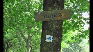
Primer tramo de la subida Sugea, comienza en el merendero de Eroseta y uniendo con los diferentes tramos de la subida nos dara un total de casi 7km de sendero hasta llegar a la cima de Goitean.

Trail Supporters
Local Trail Association

Recent Activity on Trail

Past Week
  • 2 rides
  • 18 miles average
6 Months
  • 23 rides
  • 15 miles avg distance
All
  • 231 rides
  • Last: Jun 20, 2026
c1c2c3c4
January
February
March
April
May
June
July
August
September
October
November
December
update trails status or condition

Sugea 1 Trail Reports

Status:
on May 27, 2026
Dry
Avg: 4.74 (32 votes)
Your vote: 0

view (965)
close
3D
Trail Conditions
  • Unknown
  • Snow Groomed
  • Snow Packed
  • Snow Covered
  • Snow Cover Partial
  • Freeze/thaw Cycle
  • Icy
  • Prevalent Mud
  • Wet
  • Variable
  • Ideal
  • Dry
  • Very Dry
Trail Flow (Ridden Direction)
Trailforks scans users ridelogs to determine the most popular direction each trail is ridden. A good flowing trail network will have most trails flowing in a single direction according to their intension.
The colour categories are based on what percentage of riders are riding a trail in its intended direction.
  • > 96%
  • > 90%
  • > 80%
  • > 70%
  • > 50%
  • < 50%
  • bi-directional trail
  • no data
Trail Last Ridden
Trailforks scans ridelogs to determine the last time a trail was ridden.
  • < 2 days
  • < 1 week
  • < 2 weeks
  • < 1 month
  • < 6 months
  • > 6 months
Trail Ridden Direction
The intended direction a trail should be ridden.
  • Downhill Only
  • Downhill Primary
  • Both Directions
  • Uphill Primary
  • Uphill Only
  • One Direction
Contribute Details
Colors indicate trail is missing specified detail.
  • Description
  • Photos
  • Description & Photos
  • Videos
Trail Popularity ?
Trailforks scans ridelogs to determine which trails are ridden the most in the last 9 months. Trails are compared with nearby trails in the same city region with a possible 25 colour shades. Think of this as a heatmap, more rides = more kinetic energy = warmer colors.
  • most popular
  • popular
  • less popular
  • not popular
ATV/ORV/OHV Filter
Max Vehicle Width
inches
US Cell Coverage
Legend
cell carrier legend

Radar Time
Activity Recordings
Trailforks uses anonymized public activity data. ?
Activity Recordings
Trailforks uses anonymized public activity data. ?
Personal Heatmap
Activity Types
all / none
Options
2
Date range month
Winter Trails
Warning A routing network for winter maps does not exist. Selecting trails using the winter trails layer has been disabled.
Missing Trails
Most Popular
Least Popular
Trails are colored based on popularity. The more popular a trail is, the more red. Less popular trails trend towards green.
Jump Magnitude Heatmap
Heatmap of where riders jump on trails. Zoom in to see individual jumps, click circles to view jump details.
BC Backroad Status

Service Road Atlas is a free to use, community-driven service for viewing and creating reports on the numerous back-country service roads around B.C. and Alberta.

map legend
Slope Aspect
Direction the slope faces
Flat N NE E SE S SW W NW
Trails Deemphasized
Trails are shown in grey.
disable
Only show trails with no bike usage.
Enable
Suggested Layers
Based on selected activity type

    Save the current map location and zoom level as your default home location whenever this page is loaded.

    Save
        Directions to sugea-1-78271 trailhead (42.999270, -1.518100)

        Photos

        61 more »
        195 |
        Nov 14, 2020 @ 4:49am
        Nov 14, 2020
        103 |
        May 22, 2022 @ 7:56am
        May 22, 2022
        113 |
        Mar 11, 2021 @ 3:18pm
        Mar 11, 2021
        91 |
        Dec 29, 2023 @ 6:34am
        Dec 29, 2023

        Videos

        1 more »
        EREMUA. Sugea!
        0:32 | 180 | Jul 23, 2024 , Zubiri

        Trail Lists

        Routes with this trail

        5.0 6 miles 1,844 ft 9 Point to Point
        Este recorrido es el primero que se abrió buscando los antiguos senderos que conectaban las que había...
        4.5 8 miles 2,295 ft 9 Point to Point
        Una de las bajadas mas largas y completas del sector del bosque de . Su acceso se realiza por la . En la...
        5.0 8 miles 2,674 ft 10 Loop
        Pequeña vuelta pero intensa.Subimos para haces ,luego una remontada por pista facil y Bajamos para volver...

        Links

        10 Reviews & Comments


        We hope you've been enjoying Trailforks!

        Create a FREE account to view trail comments and much more.

        Nearby Trails

        • By tronchonikTF Pro & contributors
        • #78271 - 2,281 views

        Frequently Asked Questions About Sugea 1

        Where is Sugea 1 located?
        Sugea 1 is located in Eremua, Zubiri, Spain. It is part of the Eremua trail network. The trailhead is located at coordinates 42.99927, -1.5181.
        How hard is Sugea 1?
        Sugea 1 is rated as Blue difficulty. The physical rating is Moderate. The average grade is 6.7%. The climb difficulty is rated Blue.
        What is the elevation gain for Sugea 1?
        Sugea 1 has 84 ft of elevation gain. The elevation ranges from 2,088 ft to 2,171 ft.
        Is Sugea 1 a point to point trail?
        Yes, Sugea 1 is a point to point trail. The direction is Uphill Only. The trail type is singletrack.

        Hit the Trail

        Open in App

        Get this trail on your phone instantly.
        open trail in app

        Download Trail

        Save to wishlist, Garmin & download.
        save the trail

        Find Related Routes

        Find routes and users activities that include this trail.
        find routes for this trail

        You must enter a description before submitting.