more stats
3.1 miles
Distance
155 ft
Climb
-1,857 ft
Descent
00:24:51
Avg time
-1,701 ft
Altitude change
1,408 ft
Altitude min
3,260 ft
Altitude max
3,215 ft
Altitude start
1,512 ft
Altitude end
-10.3%
Grade
-71.8%
Grade max
32.4%
Grade min
1,716 ft
Distance climb
3 miles
Distance down
928 ft
Distance flat
00:24:51
Avg time

Summit Springs Details

  • Activities
    • Mountain Bike
    • Horse
    • Hike
    • Trail Running
  • Riding Area
    Silver Star Scenic Area
    North Bonneville, Washington
  • Ref Number
    #173
  • Difficulty Rating
  • Voted Difficulty
    Black Diamond (2 votes)
  • Local Popularity
    100 in Mountain Biking [+]
    • 5 in Trail Running
    • 5 in Hiking
    • 5 in Horseback
  • Global Ranking
    #40909 in Mountain Biking [+]
    • #137332 in Trail Running
    • #131419 in Hiking
    • #1482 in Horseback
  • Hiking SAC Scale
    T1 Hiking
  • Trail Type
    Singletrack
  • Bike Type
    DH, AM, XC
  • Direction
    Downhill Primary
    Popular Direction Shown
  • Climb Difficulty
    Black Diamond
  • Physical Rating
    Hard
  • Trail Visibility
    Always easy to follow
  • Season
    Spring, Summer, Fall
  • Dogs Allowed
    Yes
  • eBike Allowed
  • TTFs on Trail
    Jump

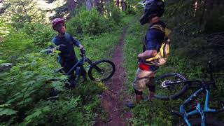
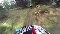
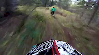
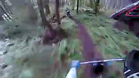
This is a very fast trail used almost exclusively by descending mountain bike riders. It features many jumps and fast corners that are bermed unless they aren't. Due to its remote location, it is not often ridden, but sure to reward anyone making the trip. It can be climbed, but most riders will find themselves pushing much of the assent. Some opt to pedal up roads NF41 to NF4104, but most choose to shuttle the road with its massive water bars.

Here's a great video describing the trail, courtesy of Josef Hoffman:
https://youtu.be/_7Xiauo_OWs

Trail Supporters

  • USFS
    Land Manager
Local Trail Association
Traditionally Indigenous Territory

Recent Activity on Trail

Past Week
  • 0 rides
  •  
6 Months
  • 1 rides
  • 13 miles avg distance
All
  • 15 rides
  • Last: May 30, 2026
c1c2c3c4
January
February
March
April
May
June
July
August
September
October
November
December
update trails status or condition

Summit Springs Trail Reports

statusdatedescription
May 4, 2025 @ 2:11pm
May 4, 2025
Trail is ripping. Dirt is dry for may, but good overall. One tree down. No other obstructions. Saw a few other tracks. Shoutout to whoever is...
Nov 9, 2024 @ 5:59pm
Nov 9, 2024
tree down
Aug 10, 2024 @ 4:18pm
Aug 10, 2024
July 27: a bit loose at the top but otherwise perfect. No trees to clear. Rode up the road which is in very good share for a NFDR. Part of the...
May 27, 2024 @ 4:46pm
May 27, 2024
Loose, fast, and fun. 2 motos went up right in front of me, could barely tell they were on the trail. Tree down in the deer trail steep section,...
May 27, 2024 @ 2:05am
May 27, 2024
more »
Status:
on May 4, 2025
Ideal
Avg: 4.35 (8 votes)
Your vote: 0

view (126)
close
3D
Trail Conditions
  • Unknown
  • Snow Groomed
  • Snow Packed
  • Snow Covered
  • Snow Cover Partial
  • Freeze/thaw Cycle
  • Icy
  • Prevalent Mud
  • Wet
  • Variable
  • Ideal
  • Dry
  • Very Dry
Trail Flow (Ridden Direction)
Trailforks scans users ridelogs to determine the most popular direction each trail is ridden. A good flowing trail network will have most trails flowing in a single direction according to their intension.
The colour categories are based on what percentage of riders are riding a trail in its intended direction.
  • > 96%
  • > 90%
  • > 80%
  • > 70%
  • > 50%
  • < 50%
  • bi-directional trail
  • no data
Trail Last Ridden
Trailforks scans ridelogs to determine the last time a trail was ridden.
  • < 2 days
  • < 1 week
  • < 2 weeks
  • < 1 month
  • < 6 months
  • > 6 months
Trail Ridden Direction
The intended direction a trail should be ridden.
  • Downhill Only
  • Downhill Primary
  • Both Directions
  • Uphill Primary
  • Uphill Only
  • One Direction
Contribute Details
Colors indicate trail is missing specified detail.
  • Description
  • Photos
  • Description & Photos
  • Videos
Trail Popularity ?
Trailforks scans ridelogs to determine which trails are ridden the most in the last 9 months. Trails are compared with nearby trails in the same city region with a possible 25 colour shades. Think of this as a heatmap, more rides = more kinetic energy = warmer colors.
  • most popular
  • popular
  • less popular
  • not popular
ATV/ORV/OHV Filter
Max Vehicle Width
inches
US Cell Coverage
Legend
cell carrier legend

Radar Time
Activity Recordings
Trailforks uses anonymized public activity data. ?
Activity Recordings
Trailforks uses anonymized public activity data. ?
Personal Heatmap
Activity Types
all / none
Options
2
Date range month
Winter Trails
Warning A routing network for winter maps does not exist. Selecting trails using the winter trails layer has been disabled.
Missing Trails
Most Popular
Least Popular
Trails are colored based on popularity. The more popular a trail is, the more red. Less popular trails trend towards green.
Jump Magnitude Heatmap
Heatmap of where riders jump on trails. Zoom in to see individual jumps, click circles to view jump details.
BC Backroad Status

Service Road Atlas is a free to use, community-driven service for viewing and creating reports on the numerous back-country service roads around B.C. and Alberta.

map legend
Slope Aspect
Direction the slope faces
Flat N NE E SE S SW W NW
Trails Deemphasized
Trails are shown in grey.
disable
Only show trails with no bike usage.
Enable
Suggested Layers
Based on selected activity type

    Save the current map location and zoom level as your default home location whenever this page is loaded.

    Save
        Directions to summit-springs trailhead (45.805980, -122.207080)

        Photos

        30 more »
        308 |
        Jul 29, 2016 @ 2:27pm
        Jul 29, 2016
        42 |
        Nov 9, 2024 @ 5:59pm
        Nov 9, 2024
        52 |
        May 27, 2024 @ 4:47pm
        May 27, 2024
        44 |
        May 27, 2024 @ 4:47pm
        May 27, 2024

        Videos

        9 more »
        youtuber VOTR-Trail 173
        4:51 | 868 | Apr 7, 2019 , North Bonneville
        173 with metal
        4:12 | 701 | Mar 3, 2015 , North Bonneville
        oneseventhree
        6:44 | 463 | Nov 14, 2014 , North Bonneville
        Sweet smooth Singletrack lower 173
        2:14 | 247 | Oct 12, 2014 , North Bonneville

        Routes with this trail

        1.5 23 miles 4,800 ft 2 Loop
        This is an very, very scenic route that connects northern ascent of Silver Star mountain, which 100%...
        22 miles 4,714 ft 3
        This route will give you a nice tour of the Yacolt Burn with some pretty epic views. There is a painful...

        5 Reviews & Comments


        We hope you've been enjoying Trailforks!

        Create a FREE account to view trail comments and much more.

        • By northwestdhdad EMBA-SW & contributors
        • #3338 - 5,703 views

        Frequently Asked Questions About Summit Springs

        Where is Summit Springs located?
        Summit Springs is located in Silver Star Scenic Area, North Bonneville, Washington, United States. It is part of the Silver Star Scenic Area trail network. The trailhead is located at coordinates 45.80598, -122.20708.
        How hard is Summit Springs?
        Summit Springs is rated as Blue difficulty. The physical rating is Hard. The average grade is 10.3%. The climb difficulty is rated Black Diamond.
        What is the elevation gain for Summit Springs?
        Summit Springs has 47 m of elevation gain. The trail has 566 m of elevation descent. The elevation ranges from 429 m to 994 m.
        Is Summit Springs a point to point trail?
        Summit Springs is not a point to point trail. The direction is Downhill Primary. The trail type is singletrack.

        Hit the Trail

        Open in App

        Get this trail on your phone instantly.
        open trail in app

        Download Trail

        Save to wishlist, Garmin & download.
        save the trail

        Find Related Routes

        Find routes and users activities that include this trail.
        find routes for this trail

        You must enter a description before submitting.