more stats
3.5 miles
Distance
168 ft
Climb
-1,728 ft
Descent
00:19:34
Avg time
-1,560 ft
Altitude change
5,809 ft
Altitude min
7,370 ft
Altitude max
7,369 ft
Altitude start
5,810 ft
Altitude end
-8.6%
Grade
-58.5%
Grade max
39.2%
Grade min
1,959 ft
Distance climb
3 miles
Distance down
1,726 ft
Distance flat
00:19:34
Avg time

Sunnegga-Trail Details

  • Activities
    • Mountain Bike
    • E-Bike
  • Riding Area
  • Ref Number
    F2
  • Difficulty Rating
  • Voted Difficulty
    Blue (1 vote)
  • Local Popularity
    100 in Mountain Biking [+]
    • 100 in E-Biking
  • Global Ranking
    #26756 in Mountain Biking [+]
    • #2225 in E-Biking
  • Trail Type
    Machine Groomed
  • Bike Type
    AM, XC
  • Direction
    Downhill Only
    Popular Direction Shown
  • Climb Difficulty
    Green
  • Physical Rating
    Moderate
  • Trail Visibility
    Always easy to follow
  • Family Friendly
    Yes
  • Dogs Allowed
    Yes
  • eBike Allowed
    Yes up to Class 1
  • TTFs on Trail
    Berm, Jump
  • Ride in Rain
    Yes
  • Year Opened
    2017

(Deutsche Übersetzung unten)

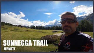
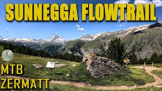
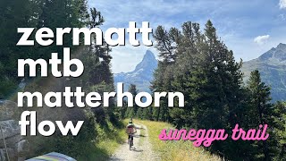
"Flow and fun are among the main attractions of the new Sunnegga-Trail – for beginners and pros alike. You’ll definitely want to ride it more than once.
The Sunnegga-Trail is easily reached by rail: in Zermatt just take the funicular up to Sunnegga. Once at the top, there’s a glimpse of the Matterhorn and off you go. The trail starts directly beneath Sunnegga Station and it’s great for beginners and professionals alike. Follow the trail for around six kilometres, dropping a total of 500m, you’ll find yourself back above Zermatt after a 15-minute ride through the woods."

---

"Der neue Sunnegga-Trail bietet vor allem eines: Flow und Spass. Für Anfänger und Pro’s. Da fährt man garantiert mehr als einmal runter.
en Sunnegga–Trail erreicht man bequem per Bahn: In Zermatt nimmt man die Standseilbahn hinauf nach Sunnegga. Oben angekommen, erhascht man einen Blick auf das Matterhorn und dann kann es losgehen. Direkt unter der Sunnegga-Station beginnt der Trail, der sich für Anfänger wie auch für Profis eignet. Auf fast sechs Kilometern geht es insgesamt 500 Tiefenmeter nach unten und nach einer 15-minütigen Fahrt durch den Wald findet man sich etwas oberhalb von Zermatt wieder."

Bike Park

Recent Activity on Trail

Past Week
  • 3 rides
  • 32.2 km average
6 Months
  • 5 rides
  • 30.4 km avg distance
All
  • 172 rides
  • Last: Jun 23, 2026
c1c2c3c4
January
February
March
April
May
June
July
August
September
October
November
December
update trails status or condition

Sunnegga-Trail Trail Reports

statusdatedescription
Sep 6, 2025 @ 9:11am
Sep 6, 2025
Du bon grip !
Jul 4, 2025 @ 10:04am
Jul 4, 2025
Jun 27, 2025 @ 8:51am
Jun 27, 2025
Sep 3, 2024 @ 9:23am
Sep 3, 2024
Jul 19, 2024 @ 5:31am
Jul 19, 2024
CAT Corriol fàcil ideal per practicar els peraltes. De fet aquesta és la seva única dificultat. En alguns moments es fa llarg per...
more »
Status:
on Sep 6, 2025
Ideal
Avg: 3.82 (22 votes)
Your vote: 0

view (1,237)
close
3D
Trail Conditions
  • Unknown
  • Snow Groomed
  • Snow Packed
  • Snow Covered
  • Snow Cover Partial
  • Freeze/thaw Cycle
  • Icy
  • Prevalent Mud
  • Wet
  • Variable
  • Ideal
  • Dry
  • Very Dry
Trail Flow (Ridden Direction)
Trailforks scans users ridelogs to determine the most popular direction each trail is ridden. A good flowing trail network will have most trails flowing in a single direction according to their intension.
The colour categories are based on what percentage of riders are riding a trail in its intended direction.
  • > 96%
  • > 90%
  • > 80%
  • > 70%
  • > 50%
  • < 50%
  • bi-directional trail
  • no data
Trail Last Ridden
Trailforks scans ridelogs to determine the last time a trail was ridden.
  • < 2 days
  • < 1 week
  • < 2 weeks
  • < 1 month
  • < 6 months
  • > 6 months
Trail Ridden Direction
The intended direction a trail should be ridden.
  • Downhill Only
  • Downhill Primary
  • Both Directions
  • Uphill Primary
  • Uphill Only
  • One Direction
Contribute Details
Colors indicate trail is missing specified detail.
  • Description
  • Photos
  • Description & Photos
  • Videos
Trail Popularity ?
Trailforks scans ridelogs to determine which trails are ridden the most in the last 9 months. Trails are compared with nearby trails in the same city region with a possible 25 colour shades. Think of this as a heatmap, more rides = more kinetic energy = warmer colors.
  • most popular
  • popular
  • less popular
  • not popular
ATV/ORV/OHV Filter
Max Vehicle Width
inches
US Cell Coverage
Legend
cell carrier legend

Radar Time
Activity Recordings
Trailforks uses anonymized public activity data. ?
Activity Recordings
Trailforks uses anonymized public activity data. ?
Personal Heatmap
Activity Types
all / none
Options
2
Date range month
Winter Trails
Warning A routing network for winter maps does not exist. Selecting trails using the winter trails layer has been disabled.
Missing Trails
Most Popular
Least Popular
Trails are colored based on popularity. The more popular a trail is, the more red. Less popular trails trend towards green.
Jump Magnitude Heatmap
Heatmap of where riders jump on trails. Zoom in to see individual jumps, click circles to view jump details.
BC Backroad Status

Service Road Atlas is a free to use, community-driven service for viewing and creating reports on the numerous back-country service roads around B.C. and Alberta.

map legend
Slope Aspect
Direction the slope faces
Flat N NE E SE S SW W NW
Trails Deemphasized
Trails are shown in grey.
disable
Only show trails with no bike usage.
Enable
Suggested Layers
Based on selected activity type

    Save the current map location and zoom level as your default home location whenever this page is loaded.

    Save
        Directions to sunneggatrail trailhead (46.018190, 7.769310)

        Photos

        9 more »
        55 |
        Sep 10, 2025 @ 2:27am
        Sep 10, 2025
        47 |
        Sep 10, 2025 @ 2:27am
        Sep 10, 2025
        321 |
        Jul 15, 2019 @ 3:40am
        Jul 15, 2019
        267 |
        Jul 1, 2019 @ 3:03am
        Jul 1, 2019

        Videos

        6 more »
        youtuber Sunnegga Trail
        17:18 | 88 | Sep 2, 2021 , Zermatt
        Sunnegga flowtrail - tam kde som riadne spadol...
        12:33 | 45 | Jan 6, 2026 , Zermatt
        Incredible Swiss Singletrack - Blauherd to...
        25:32 | 91 | Aug 19, 2025 , Zermatt
        Mountain Biking Zermatt Switzerland: Awesome...
        33:32 | 147 | Sep 26, 2024 , Zermatt

        5 Reviews & Comments


        We hope you've been enjoying Trailforks!

        Create a FREE account to view trail comments and much more.

        • By inversedotchTF Pro & contributors
        • #144461 - 7,273 views

        Frequently Asked Questions About Sunnegga-Trail

        Where is Sunnegga-Trail located?
        Sunnegga-Trail is located in Zermatt - Matterhorn, Zermatt, Switzerland. It is part of the Zermatt - Matterhorn trail network. The trailhead is located at coordinates 46.01819, 7.76931.
        How hard is Sunnegga-Trail?
        Sunnegga-Trail is rated as Blue difficulty. The physical rating is Moderate. The average grade is 8.6%. The climb difficulty is rated Green.
        What is the elevation gain for Sunnegga-Trail?
        Sunnegga-Trail has 51 m of elevation gain. The trail has 527 m of elevation descent. The elevation ranges from 1,771 m to 2,246 m.
        Is Sunnegga-Trail a point to point trail?
        Yes, Sunnegga-Trail is a point to point trail. The direction is Downhill Only. The trail type is machine groomed.

        Hit the Trail

        Open in App

        Get this trail on your phone instantly.
        open trail in app

        Download Trail

        Save to wishlist, Garmin & download.
        save the trail

        Find Related Routes

        Find routes and users activities that include this trail.
        find routes for this trail

        You must enter a description before submitting.