more stats
2.2 miles
Distance
112 ft
Climb
-1,354 ft
Descent
00:16:05
Avg time
-1,241 ft
Altitude change
2,189 ft
Altitude min
3,433 ft
Altitude max
3,433 ft
Altitude start
2,192 ft
Altitude end
-10.6%
Grade
-63.6%
Grade max
23.3%
Grade min
2,047 ft
Distance climb
2 miles
Distance down
259 ft
Distance flat
00:16:05
Avg time

Sunset Ridge Details

  • Activities
    • Mountain Bike
    • Hike
    • Trail Running
  • Riding Area
    Angeles National Forest
    Pasadena, California
  • Difficulty Rating
  • Voted Difficulty
    Double Black Diamond (3 votes)
  • Local Popularity
    100 in Mountain Biking [+]
    • 75 in Trail Running
    • 75 in Hiking
  • Global Ranking
    #8057 in Mountain Biking [+]
    • #1610 in Trail Running
    • #1525 in Hiking
  • Trail Type
    Singletrack
  • Bike Type
    DH, AM
  • Direction
    Downhill Primary
    Popular Direction Shown
  • Physical Rating
    Moderate
  • Dogs Allowed
    Yes
  • eBike Allowed
  • TTFs on Trail
    Drop, Skinny

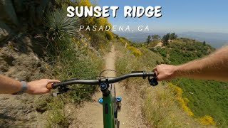
Sunset Ridge is one of the most fun and challenging single tracks in the front side of Angeles National Forest. It's normally ridden downhill but definitely use a bell and be aware of hikers & trail runners, especially on busy weekends. There are many rock drops, tight switchbacks, and plenty of extreme exposure. A seriously fun trail with equally serious consequences. Definitely take it easy your first time. Sunset Ridge is a fantastic trail with great views and many challenges.

Access Info

You can access Sunset via Chaney Trail and climbing up the paved fire road. It's a steep climb up the paved road and Sunset starts from the left of the road almost 2.5 miles from the locked gate.

You can also get to Sunset by climbing up the Lower Sam Merrill trail at the top of Lake Ave. This trail is heavily switchbacked and very, very popular with hikers. If you go this route, you hang a left at the top on the connector trail and climb up to the paved fire road. From there descend maybe 50 yards and Sunset Ridge will be on your right hand side.

Trail Supporters

  • USFS
    Land Manager
Local Trail Association
Traditionally Indigenous Territory

Recent Activity on Trail

Past Week
  • 1 rides
  • 7 miles average
6 Months
  • 112 rides
  • 11 miles avg distance
All
  • 487 rides
  • Last: Jun 22, 2026
c1c2c3c4
January
February
March
April
May
June
July
August
September
October
November
December
update trails status or condition

Sunset Ridge Trail Reports

statusdatedescription
Apr 22, 2026 @ 10:52am (America/Los_Angeles)
Apr 22, 2026
Great dirt, trail encroached by tons of sharp weeds and poodle dog, came away with rashes. Wear pants! Rode on 4/15 and reporting very late.
Mar 14, 2026 @ 10:09pm (America/Los_Angeles)
Mar 14, 2026
Jan 26, 2026 @ 8:06am (America/Los_Angeles)
Jan 26, 2026
Running well.
Jan 25, 2026 @ 9:14am (America/Los_Angeles)
Jan 25, 2026
Jan 9, 2026 @ 12:34pm (America/Los_Angeles)
Jan 9, 2026
open
more »
Status:
on Apr 22, 2026
Ideal
Avg: 4.64 (39 votes)
Your vote: 0

view (6,548)
close
3D
Trail Conditions
  • Unknown
  • Snow Groomed
  • Snow Packed
  • Snow Covered
  • Snow Cover Partial
  • Freeze/thaw Cycle
  • Icy
  • Prevalent Mud
  • Wet
  • Variable
  • Ideal
  • Dry
  • Very Dry
Trail Flow (Ridden Direction)
Trailforks scans users ridelogs to determine the most popular direction each trail is ridden. A good flowing trail network will have most trails flowing in a single direction according to their intension.
The colour categories are based on what percentage of riders are riding a trail in its intended direction.
  • > 96%
  • > 90%
  • > 80%
  • > 70%
  • > 50%
  • < 50%
  • bi-directional trail
  • no data
Trail Last Ridden
Trailforks scans ridelogs to determine the last time a trail was ridden.
  • < 2 days
  • < 1 week
  • < 2 weeks
  • < 1 month
  • < 6 months
  • > 6 months
Trail Ridden Direction
The intended direction a trail should be ridden.
  • Downhill Only
  • Downhill Primary
  • Both Directions
  • Uphill Primary
  • Uphill Only
  • One Direction
Contribute Details
Colors indicate trail is missing specified detail.
  • Description
  • Photos
  • Description & Photos
  • Videos
Trail Popularity ?
Trailforks scans ridelogs to determine which trails are ridden the most in the last 9 months. Trails are compared with nearby trails in the same city region with a possible 25 colour shades. Think of this as a heatmap, more rides = more kinetic energy = warmer colors.
  • most popular
  • popular
  • less popular
  • not popular
ATV/ORV/OHV Filter
Max Vehicle Width
inches
US Cell Coverage
Legend
cell carrier legend

Radar Time
Activity Recordings
Trailforks uses anonymized public activity data. ?
Activity Recordings
Trailforks uses anonymized public activity data. ?
Personal Heatmap
Activity Types
all / none
Options
2
Date range month
Winter Trails
Warning A routing network for winter maps does not exist. Selecting trails using the winter trails layer has been disabled.
Missing Trails
Most Popular
Least Popular
Trails are colored based on popularity. The more popular a trail is, the more red. Less popular trails trend towards green.
Jump Magnitude Heatmap
Heatmap of where riders jump on trails. Zoom in to see individual jumps, click circles to view jump details.
BC Backroad Status

Service Road Atlas is a free to use, community-driven service for viewing and creating reports on the numerous back-country service roads around B.C. and Alberta.

map legend
Slope Aspect
Direction the slope faces
Flat N NE E SE S SW W NW
Trails Deemphasized
Trails are shown in grey.
disable
Only show trails with no bike usage.
Enable
Suggested Layers
Based on selected activity type

    Save the current map location and zoom level as your default home location whenever this page is loaded.

    Save
        Directions to sunset-ridge trailhead (34.217740, -118.126950)

        Photos

        33 more »
        88 |
        Feb 1, 2026 @ 2:50pm
        Feb 1, 2026
        363 |
        Dec 11, 2021 @ 5:43pm
        Dec 11, 2021
        329 |
        May 30, 2021 @ 8:11pm
        May 30, 2021
        337 |
        Jul 4, 2020 @ 6:03pm
        Jul 4, 2020

        Videos

        35 more »
        youtuber Sunset Ridge Trail / Altadena, CA / MTB
        12:06 | 293 | Sep 25, 2023 , Pasadena
        youtuber Sunset Ridge / Pasadena, CA / MTB
        10:45 | 242 | Aug 8, 2024 , Pasadena
        youtuber I've Never Ridden Anything Like This
        12:44 | 494 | Apr 1, 2023 , Pasadena
        youtuber Sunset Ridge Trail - Mt. Wilson - Altadena, CA
        12:48 | 1112 | Oct 7, 2018 , Pasadena

        Routes with this trail

        5.0 8 miles 691 ft 7 Shuttled
        Shuttle run from top of Mt. Lowe East to the bottom of .
        5.0 13 miles 1,514 ft 12 Shuttled
        This shuttle Route is one Variation of the so called Front side riding area in the Angeles National Forest.
        4.0 14 miles 840 ft 14
        Mt.Wilson shuttle is one of Southern California's most challenging trails, so much fun!

        19 Reviews & Comments


        We hope you've been enjoying Trailforks!

        Create a FREE account to view trail comments and much more.

        • By betamax-bandit & contributors
        • #20979 - 13,758 views

        Frequently Asked Questions About Sunset Ridge

        Where is Sunset Ridge located?
        Sunset Ridge is located in Angeles National Forest, Pasadena, California, United States. It is part of the Angeles National Forest trail network. The trailhead is located at coordinates 34.21774, -118.12695.
        How hard is Sunset Ridge?
        Sunset Ridge is rated as Black Diamond difficulty. The physical rating is Moderate. The average grade is 10.6%.
        What is the elevation gain for Sunset Ridge?
        Sunset Ridge has 112 ft of elevation gain. The trail has 1,354 ft of elevation descent. The elevation ranges from 2,189 ft to 3,433 ft.
        Is Sunset Ridge a point to point trail?
        Sunset Ridge is not a point to point trail. The direction is Downhill Primary. The trail type is singletrack.

        Hit the Trail

        Open in App

        Get this trail on your phone instantly.
        open trail in app

        Download Trail

        Save to wishlist, Garmin & download.
        save the trail

        Find Related Routes

        Find routes and users activities that include this trail.
        find routes for this trail

        You must enter a description before submitting.