more stats
991 ft
Distance
-168 ft
Descent
00:01:11
Avg time
-168 ft
Altitude change
1,384 ft
Altitude min
1,552 ft
Altitude max
1,552 ft
Altitude start
1,385 ft
Altitude end
-16.9%
Grade
-26.9%
Grade max
-7.1%
Grade min
991 ft
Distance down
00:01:11
Avg time

Swashbuckler Details

  • Activities
    • Mountain Bike
    • E-Bike
    • Hike
    • Trail Running
  • Riding Area
    HammerFest
    Parksville, British Columbia
  • Difficulty Rating
  • Local Popularity
    80 in Mountain Biking [+]
    • 85 in E-Biking
    • 55 in Trail Running
    • 55 in Hiking
  • Global Ranking
    #45839 in Mountain Biking [+]
    • #25827 in E-Biking
    • #102143 in Trail Running
    • #85852 in Hiking
  • Trail Type
    Singletrack
  • Bike Type
    AM, XC
  • Direction
    Downhill Only
    Popular Direction Shown
  • Physical Rating
    Moderate
  • eBike Allowed
  • Year Opened
    2015
  • Land Owner
    Mosaic Forest Management

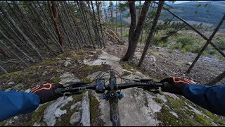
Short but fun ride with flow and berms at the top and then a gouged out, trenched fall line finish.

Access Info

Take road south of Machete for about 200m then watch for rough trail on the right. Trail follows the old Silver Hammer trail uphill.

Trail Supporters
  • Dirt Pirates
    Builder
Local Trail Association
Traditionally Indigenous Territory

Recent Activity on Trail

Past Week
  • 7 rides
  • 8 miles average
6 Months
  • 154 rides
  • 9 miles avg distance
All
  • 1,266 rides
  • Last: Jun 17, 2026
c1c2c3c4
January
February
March
April
May
June
July
August
September
October
November
December
Status:
on Mar 22, 2026
Ideal
Avg: 4.14 (16 votes)
Your vote: 0

view (3,311)
close
3D
Trail Conditions
  • Unknown
  • Snow Groomed
  • Snow Packed
  • Snow Covered
  • Snow Cover Partial
  • Freeze/thaw Cycle
  • Icy
  • Prevalent Mud
  • Wet
  • Variable
  • Ideal
  • Dry
  • Very Dry
Trail Flow (Ridden Direction)
Trailforks scans users ridelogs to determine the most popular direction each trail is ridden. A good flowing trail network will have most trails flowing in a single direction according to their intension.
The colour categories are based on what percentage of riders are riding a trail in its intended direction.
  • > 96%
  • > 90%
  • > 80%
  • > 70%
  • > 50%
  • < 50%
  • bi-directional trail
  • no data
Trail Last Ridden
Trailforks scans ridelogs to determine the last time a trail was ridden.
  • < 2 days
  • < 1 week
  • < 2 weeks
  • < 1 month
  • < 6 months
  • > 6 months
Trail Ridden Direction
The intended direction a trail should be ridden.
  • Downhill Only
  • Downhill Primary
  • Both Directions
  • Uphill Primary
  • Uphill Only
  • One Direction
Contribute Details
Colors indicate trail is missing specified detail.
  • Description
  • Photos
  • Description & Photos
  • Videos
Trail Popularity ?
Trailforks scans ridelogs to determine which trails are ridden the most in the last 9 months. Trails are compared with nearby trails in the same city region with a possible 25 colour shades. Think of this as a heatmap, more rides = more kinetic energy = warmer colors.
  • most popular
  • popular
  • less popular
  • not popular
ATV/ORV/OHV Filter
Max Vehicle Width
inches
US Cell Coverage
Legend
cell carrier legend

Radar Time
Activity Recordings
Trailforks uses anonymized public activity data. ?
Activity Recordings
Trailforks uses anonymized public activity data. ?
Personal Heatmap
Activity Types
all / none
Options
2
Date range month
Winter Trails
Warning A routing network for winter maps does not exist. Selecting trails using the winter trails layer has been disabled.
Missing Trails
Most Popular
Least Popular
Trails are colored based on popularity. The more popular a trail is, the more red. Less popular trails trend towards green.
Jump Magnitude Heatmap
Heatmap of where riders jump on trails. Zoom in to see individual jumps, click circles to view jump details.
BC Backroad Status

Service Road Atlas is a free to use, community-driven service for viewing and creating reports on the numerous back-country service roads around B.C. and Alberta.

map legend
Slope Aspect
Direction the slope faces
Flat N NE E SE S SW W NW
Trails Deemphasized
Trails are shown in grey.
disable
Only show trails with no bike usage.
Enable
Suggested Layers
Based on selected activity type

    Save the current map location and zoom level as your default home location whenever this page is loaded.

    Save
        Directions to swashbuckler trailhead (49.229980, -124.387080)

        Photos

        8 more »
        223 |
        Dec 16, 2017 @ 3:09pm
        Dec 16, 2017
        207 |
        Dec 16, 2017 @ 3:09pm
        Dec 16, 2017
        196 |
        Dec 16, 2017 @ 3:08pm
        Dec 16, 2017
        122 |
        Mar 3, 2022 @ 1:05pm
        Mar 3, 2022

        Videos

        4 more »
        HammerFest | Parksville, BC
        8:40 | 101 | Mar 1, 2025 , Parksville
        Top to Bottom (Swashbuckler section) -...
        12:50 | 190 | Oct 10, 2022 , Parksville
        lil hammerfest rip (Swashbuckler)
        11:27 | 165 | Jul 23, 2022 , Parksville
        Derren Berreclorh on swashbucler
        0:48 | 354 | Jun 27, 2020 , Parksville

        Routes with this trail

        6 miles 1,115 ft 18 Loop
        An easy way up Hammerfest. Cross-country style on the way up and flowy on the way down. Avoiding service...

        7 Reviews & Comments


        We hope you've been enjoying Trailforks!

        Create a FREE account to view trail comments and much more.

        Nearby Trails

        • By rapid-royTF Pro TrailsBC ACC & contributors
        • #31738 - 2,597 views

        Frequently Asked Questions About Swashbuckler

        Where is Swashbuckler located?
        Swashbuckler is located in HammerFest, Parksville, British Columbia, Canada. It is part of the HammerFest trail network. The trailhead is located at coordinates 49.22998, -124.38708.
        How hard is Swashbuckler?
        Swashbuckler is rated as Black Diamond difficulty. The physical rating is Moderate. The average grade is 16.9%.
        What is the elevation gain for Swashbuckler?
        The trail has 168 ft of elevation descent. The elevation ranges from 1,384 ft to 1,552 ft.
        Is Swashbuckler a point to point trail?
        Yes, Swashbuckler is a point to point trail. The direction is Downhill Only. The trail type is singletrack.

        Hit the Trail

        Open in App

        Get this trail on your phone instantly.
        open trail in app

        Download Trail

        Save to wishlist, Garmin & download.
        save the trail

        Find Related Routes

        Find routes and users activities that include this trail.
        find routes for this trail

        You must enter a description before submitting.