more stats
1.3 miles
Distance
433 ft
Climb
-18 ft
Descent
00:14:24
Avg time
415 ft
Altitude change
2,241 ft
Altitude min
2,671 ft
Altitude max
2,241 ft
Altitude start
2,657 ft
Altitude end
6.1%
Grade
-11.4%
Grade max
30.9%
Grade min
1 mile
Distance climb
358 ft
Distance down
722 ft
Distance flat
00:14:24
Avg time

Sweet Jane Details

  • Activities
    • Mountain Bike
    • Hike
    • Trail Running
  • Riding Area
    Candle Creek
    Clearwater, British Columbia
  • Difficulty Rating
  • Global Ranking
    #170345 in Mountain Biking [+]
    • #200167 in Trail Running
    • #237162 in Hiking
  • Trail Type
    Singletrack
  • Bike Type
    AM
  • Direction
    Both Directions
  • Climb Difficulty
    Blue
  • Physical Rating
    Moderate
  • Season
    Apr - Oct
  • Dogs Allowed
    Yes
  • eBike Allowed
    Yes up to Class 1
  • Ride in Rain
    Yes
  • Year Opened
    2016
  • Land Owner
    Wells Gray Outdoors Club

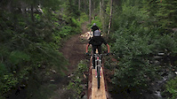
Sweet Jane flow trail built in 2016 with pumps and rollers, a fun step down / step up through a gully. Descends through open Fir forests and brushy cutblocks. Nice finish with open swoopy turns in mature forest. Great climbing trail as well - loop with Freebird descent.

Access Info

Can be accessed from Ridge Loop Barber Rd trail head or trail head at 4.5 km Road 9 FSR.

Trail Supporters
Local Trail Association
Traditionally Indigenous Territory

Recent Activity on Trail

Past Week
  • 1 rides
  • 32.5 km average
6 Months
  • 10 rides
  • 15.8 km avg distance
All
  • 134 rides
  • Last: Jun 20, 2026
c1c2c3c4
January
February
March
April
May
June
July
August
September
October
November
December
update trails status or condition

Sweet Jane Trail Reports

statusdatedescription
Apr 26, 2026 @ 8:23am (America/Vancouver)
Apr 26, 2026
reporter
Apr 4, 2026 @ 6:14pm (America/Vancouver)
Apr 4, 2026
reporter Lower section still wet / closed.
Mar 31, 2026 @ 8:36pm (America/Vancouver)
Mar 31, 2026
reporter
Apr 6, 2025 @ 7:50am
Apr 6, 2025
reporter All of Sweet Jane is now open. A few wet soft spots.
Mar 26, 2025 @ 6:55pm
Mar 26, 2025
reporter Lower Sweet Jane is closed until it dries
more »
Status:
on Apr 26, 2026
Avg: 3.57 (6 votes)
Your vote: 0

view (549)
close
3D
Trail Conditions
  • Unknown
  • Snow Groomed
  • Snow Packed
  • Snow Covered
  • Snow Cover Partial
  • Freeze/thaw Cycle
  • Icy
  • Prevalent Mud
  • Wet
  • Variable
  • Ideal
  • Dry
  • Very Dry
Trail Flow (Ridden Direction)
Trailforks scans users ridelogs to determine the most popular direction each trail is ridden. A good flowing trail network will have most trails flowing in a single direction according to their intension.
The colour categories are based on what percentage of riders are riding a trail in its intended direction.
  • > 96%
  • > 90%
  • > 80%
  • > 70%
  • > 50%
  • < 50%
  • bi-directional trail
  • no data
Trail Last Ridden
Trailforks scans ridelogs to determine the last time a trail was ridden.
  • < 2 days
  • < 1 week
  • < 2 weeks
  • < 1 month
  • < 6 months
  • > 6 months
Trail Ridden Direction
The intended direction a trail should be ridden.
  • Downhill Only
  • Downhill Primary
  • Both Directions
  • Uphill Primary
  • Uphill Only
  • One Direction
Contribute Details
Colors indicate trail is missing specified detail.
  • Description
  • Photos
  • Description & Photos
  • Videos
Trail Popularity ?
Trailforks scans ridelogs to determine which trails are ridden the most in the last 9 months. Trails are compared with nearby trails in the same city region with a possible 25 colour shades. Think of this as a heatmap, more rides = more kinetic energy = warmer colors.
  • most popular
  • popular
  • less popular
  • not popular
ATV/ORV/OHV Filter
Max Vehicle Width
inches
US Cell Coverage
Legend
cell carrier legend

Radar Time
Activity Recordings
Trailforks uses anonymized public activity data. ?
Activity Recordings
Trailforks uses anonymized public activity data. ?
Personal Heatmap
Activity Types
all / none
Options
2
Date range month
Winter Trails
Warning A routing network for winter maps does not exist. Selecting trails using the winter trails layer has been disabled.
Missing Trails
Most Popular
Least Popular
Trails are colored based on popularity. The more popular a trail is, the more red. Less popular trails trend towards green.
Jump Magnitude Heatmap
Heatmap of where riders jump on trails. Zoom in to see individual jumps, click circles to view jump details.
BC Backroad Status

Service Road Atlas is a free to use, community-driven service for viewing and creating reports on the numerous back-country service roads around B.C. and Alberta.

map legend
Slope Aspect
Direction the slope faces
Flat N NE E SE S SW W NW
Trails Deemphasized
Trails are shown in grey.
disable
Only show trails with no bike usage.
Enable
Suggested Layers
Based on selected activity type

    Save the current map location and zoom level as your default home location whenever this page is loaded.

    Save
        Directions to sweet-jane trailhead (51.655010, -119.969210)

        Photos

        15 more »
        105 |
        Jun 12, 2021 @ 9:28pm
        Jun 12, 2021
        243 |
        Oct 7, 2019 @ 9:43am
        Oct 7, 2019
        129 |
        Oct 10, 2018 @ 8:09am
        Oct 10, 2018
        138 |
        Jun 30, 2018 @ 9:15pm
        Jun 30, 2018

        Videos

        2 more »
        Sugar & Sweet One: Sun Peaks Bike Park
        4:59 | 1788 | Jul 22, 2015 , Clearwater
        Sun Peaks - Sugar and Sweet One
        4:59 | 9079 | Jul 20, 2015 , Clearwater

        2 Reviews & Comments


        We hope you've been enjoying Trailforks!

        Create a FREE account to view trail comments and much more.

        • By solmountainTF Pro WGOC & contributors
        • #60680 - 2,243 views

        Frequently Asked Questions About Sweet Jane

        Where is Sweet Jane located?
        Sweet Jane is located in Candle Creek, Clearwater, British Columbia, Canada. It is part of the Candle Creek trail network. The trailhead is located at coordinates 51.65501, -119.96921.
        How hard is Sweet Jane?
        Sweet Jane is rated as Blue difficulty. The physical rating is Moderate. The average grade is 6.1%. The climb difficulty is rated Blue.
        What is the elevation gain for Sweet Jane?
        Sweet Jane has 132 m of elevation gain. The trail has 6 m of elevation descent. The elevation ranges from 683 m to 814 m.
        Is Sweet Jane a point to point trail?
        Sweet Jane is not a point to point trail. The direction is Both Directions. The trail type is singletrack.

        Hit the Trail

        Open in App

        Get this trail on your phone instantly.
        open trail in app

        Download Trail

        Save to wishlist, Garmin & download.
        save the trail

        Find Related Routes

        Find routes and users activities that include this trail.
        find routes for this trail

        You must enter a description before submitting.