more stats
3.6 miles
Distance
289 ft
Climb
-879 ft
Descent
00:38:16
Avg time
-590 ft
Altitude change
680 ft
Altitude min
1,379 ft
Altitude max
1,275 ft
Altitude start
685 ft
Altitude end
-3.084%
Grade
-18.683%
Grade max
15.639%
Grade min
1 mile
Distance climb
2 miles
Distance down
629 ft
Distance flat
00:38:16
Avg time

Syfydrin Trail Details

  • Activities
    • Mountain Bike
    • Gravel Bike
    • Adaptive Bike
    • Hike
    • Trail Running
  • Riding Area
    Bwlch Nant yr Arian
    Aberystwyth
  • Difficulty Rating
  • Voted Difficulty
    Black (1 vote)
  • Local Popularity
    60 in Mountain Biking [+]
    • 5 in Trail Running
    • 5 in Hiking
  • Global Ranking
    #97699 in Mountain Biking [+]
    • #132067 in Trail Running
    • #125279 in Hiking
  • Trail Type
    Doubletrack
  • Bike Type
    AM, XC, Gravel, Adaptive MTB
  • Direction
    Both Directions[+]
    Popular Direction Shown
    • Both Directions for Gravel Biking
  • Climb Difficulty
    Blue
  • Physical Rating
    Hard
  • Dogs Allowed
    Yes
  • TTFs on Trail
    Drop, Jump, Rock Face

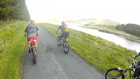
"We almost don’t want to tell you about Syfydrin because it’s the wild, desolate, lonely beauty of the far loops of this route that create its magic. A unique mix of technical singletrack and ethereal emptiness, this genuine mountain route is one to savour, but certainly not one to underestimate."

Recent Activity on Trail

Past Week
  • 1 rides
  • 22 miles average
6 Months
  • 1 rides
  • 22 miles avg distance
All
  • 22 rides
  • Last: Jun 21, 2026
c1c2c3c4
January
February
March
April
May
June
July
August
September
October
November
December
update trails status or condition

Syfydrin Trail Trail Reports

statusdatedescription
May 20, 2023 @ 1:35am
May 20, 2023
Yes there are big puddles but you'll be fine.
Jun 4, 2022 @ 4:44am
Jun 4, 2022
Massive unpassable puddles all the way around totally crap
Dec 19, 2021 @ 3:16am
Dec 19, 2021
Jul 22, 2019 @ 2:03am
Jul 22, 2019
May 23, 2019 @ 3:09am
May 23, 2019
more »
Status:
on May 20, 2023
Wet
Avg: 3.69 (7 votes)
Your vote: 0

view (379)
close
3D
Trail Conditions
  • Unknown
  • Snow Groomed
  • Snow Packed
  • Snow Covered
  • Snow Cover Partial
  • Freeze/thaw Cycle
  • Icy
  • Prevalent Mud
  • Wet
  • Variable
  • Ideal
  • Dry
  • Very Dry
Trail Flow (Ridden Direction)
Trailforks scans users ridelogs to determine the most popular direction each trail is ridden. A good flowing trail network will have most trails flowing in a single direction according to their intension.
The colour categories are based on what percentage of riders are riding a trail in its intended direction.
  • > 96%
  • > 90%
  • > 80%
  • > 70%
  • > 50%
  • < 50%
  • bi-directional trail
  • no data
Trail Last Ridden
Trailforks scans ridelogs to determine the last time a trail was ridden.
  • < 2 days
  • < 1 week
  • < 2 weeks
  • < 1 month
  • < 6 months
  • > 6 months
Trail Ridden Direction
The intended direction a trail should be ridden.
  • Downhill Only
  • Downhill Primary
  • Both Directions
  • Uphill Primary
  • Uphill Only
  • One Direction
Contribute Details
Colors indicate trail is missing specified detail.
  • Description
  • Photos
  • Description & Photos
  • Videos
Trail Popularity ?
Trailforks scans ridelogs to determine which trails are ridden the most in the last 9 months. Trails are compared with nearby trails in the same city region with a possible 25 colour shades. Think of this as a heatmap, more rides = more kinetic energy = warmer colors.
  • most popular
  • popular
  • less popular
  • not popular
ATV/ORV/OHV Filter
Max Vehicle Width
inches
US Cell Coverage
Legend
cell carrier legend

Radar Time
Activity Recordings
Trailforks uses anonymized public activity data. ?
Activity Recordings
Trailforks uses anonymized public activity data. ?
Personal Heatmap
Activity Types
all / none
Options
2
Date range month
Winter Trails
Warning A routing network for winter maps does not exist. Selecting trails using the winter trails layer has been disabled.
Missing Trails
Most Popular
Least Popular
Trails are colored based on popularity. The more popular a trail is, the more red. Less popular trails trend towards green.
Jump Magnitude Heatmap
Heatmap of where riders jump on trails. Zoom in to see individual jumps, click circles to view jump details.
BC Backroad Status

Service Road Atlas is a free to use, community-driven service for viewing and creating reports on the numerous back-country service roads around B.C. and Alberta.

map legend
Slope Aspect
Direction the slope faces
Flat N NE E SE S SW W NW
Trails Deemphasized
Trails are shown in grey.
disable
Only show trails with no bike usage.
Enable
Suggested Layers
Based on selected activity type

    Save the current map location and zoom level as your default home location whenever this page is loaded.

    Save
        Directions to syfydrin-trail trailhead (52.480200, -3.862200)

        Photos

        11 more »
        102 |
        Jun 12, 2022 @ 2:34pm
        Jun 12, 2022
        161 |
        Apr 14, 2017 @ 9:33am
        Apr 14, 2017
        119 |
        Apr 3, 2017 @ 7:15am
        Apr 3, 2017
        135 |
        Apr 3, 2017 @ 7:08am
        Apr 3, 2017

        Videos

        1 more »
        Nant yr Arian swmtb
        13:01 | 412 | May 30, 2015 , Aberystwyth

        Routes with this trail

        17 miles 2,037 ft 22 Out & Back
        Great route which combines the best of the backcountry riding on offer at Bwlch Nant yr Arian with the...
        22 miles 2,719 ft 27 Out & Back
        The complete 35km Syfydrin trail which combines excellent techincal singletrack and lung-busting climbs...

        2 Reviews & Comments


        We hope you've been enjoying Trailforks!

        Create a FREE account to view trail comments and much more.

        • By jonathono & contributors
        • #21162 - 3,926 views

        Frequently Asked Questions About Syfydrin Trail

        Where is Syfydrin Trail located?
        Syfydrin Trail is located in Bwlch Nant yr Arian, Aberystwyth, United Kingdom. It is part of the Bwlch Nant yr Arian trail network. The trailhead is located at coordinates 52.4802, -3.8622.
        How hard is Syfydrin Trail?
        Syfydrin Trail is rated as Black difficulty. The physical rating is Hard. The average grade is 3.084%. The climb difficulty is rated Blue.
        What is the elevation gain for Syfydrin Trail?
        Syfydrin Trail has 88 m of elevation gain. The trail has 268 m of elevation descent. The elevation ranges from 207 m to 420 m.
        Is Syfydrin Trail a point to point trail?
        Syfydrin Trail is not a point to point trail. The direction is Both Directions. The trail type is doubletrack.

        Hit the Trail

        Open in App

        Get this trail on your phone instantly.
        open trail in app

        Download Trail

        Save to wishlist, Garmin & download.
        save the trail

        Find Related Routes

        Find routes and users activities that include this trail.
        find routes for this trail

        You must enter a description before submitting.