more stats
2.3 miles
Distance
774 ft
Climb
-91 ft
Descent
00:27:57
Avg time
684 ft
Altitude change
4,684 ft
Altitude min
5,392 ft
Altitude max
4,695 ft
Altitude start
5,381 ft
Altitude end
5.7%
Grade
-20.3%
Grade max
32.5%
Grade min
2 miles
Distance climb
1,516 ft
Distance down
1,923 ft
Distance flat
00:27:57
Avg time

Tabeguache Details

  • Activities
    • Mountain Bike
    • Hike
    • Trail Running
  • Riding Area
    Lunch Loops
    Grand Junction, Colorado
  • Difficulty Rating
  • Voted Difficulty
    Black Diamond (3 votes)
  • Local Popularity
    90 in Mountain Biking [+]
    • 95 in Trail Running
    • 95 in Hiking
  • Global Ranking
    #47707 in Mountain Biking [+]
    • #20377 in Trail Running
    • #22895 in Hiking
  • Trail Type
    Singletrack
  • Direction
    Both Directions
    Popular Direction Shown
  • Dogs Allowed
    Yes
  • eBike Allowed
  • Land Owner
    Grand Junction Field Office of the BLM

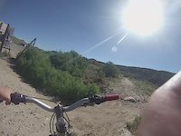
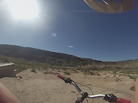
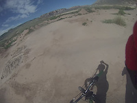
Tabegauche (pronounced \"Tab-uh-watch\") is the spine-trail of the Lunch Loops, connecting the trails together. Starting from the TH Tabegauche climbs gently to the Pet-e-Kes/Moto turn-offs, then becomes more aggressively steep and occasionally riddled with boulders that range in size from cookies to cantaloupes. But don't be dissuaded, best-lines are obvious, particularly if you need a fast down back to the main TH. Be aware that Tabegauche is a favorite for hikers and trail runners, who have the right of way.

Trail Supporters
  • BLM
    BLM
    Land Manager
Local Trail Association
Traditionally Indigenous Territory

Recent Activity on Trail

Past Week
  • 1 rides
  • 6 miles average
6 Months
  • 99 rides
  • 14 miles avg distance
All
  • 841 rides
  • Last: Jun 20, 2026
c1c2c3c4
January
February
March
April
May
June
July
August
September
October
November
December
Status:
on Jun 6, 2026
Dry
Avg: 3.29 (18 votes)
Your vote: 0

view (6,158)
close
3D
Trail Conditions
  • Unknown
  • Snow Groomed
  • Snow Packed
  • Snow Covered
  • Snow Cover Partial
  • Freeze/thaw Cycle
  • Icy
  • Prevalent Mud
  • Wet
  • Variable
  • Ideal
  • Dry
  • Very Dry
Trail Flow (Ridden Direction)
Trailforks scans users ridelogs to determine the most popular direction each trail is ridden. A good flowing trail network will have most trails flowing in a single direction according to their intension.
The colour categories are based on what percentage of riders are riding a trail in its intended direction.
  • > 96%
  • > 90%
  • > 80%
  • > 70%
  • > 50%
  • < 50%
  • bi-directional trail
  • no data
Trail Last Ridden
Trailforks scans ridelogs to determine the last time a trail was ridden.
  • < 2 days
  • < 1 week
  • < 2 weeks
  • < 1 month
  • < 6 months
  • > 6 months
Trail Ridden Direction
The intended direction a trail should be ridden.
  • Downhill Only
  • Downhill Primary
  • Both Directions
  • Uphill Primary
  • Uphill Only
  • One Direction
Contribute Details
Colors indicate trail is missing specified detail.
  • Description
  • Photos
  • Description & Photos
  • Videos
Trail Popularity ?
Trailforks scans ridelogs to determine which trails are ridden the most in the last 9 months. Trails are compared with nearby trails in the same city region with a possible 25 colour shades. Think of this as a heatmap, more rides = more kinetic energy = warmer colors.
  • most popular
  • popular
  • less popular
  • not popular
ATV/ORV/OHV Filter
Max Vehicle Width
inches
US Cell Coverage
Legend
cell carrier legend

Radar Time
Activity Recordings
Trailforks uses anonymized public activity data. ?
Activity Recordings
Trailforks uses anonymized public activity data. ?
Personal Heatmap
Activity Types
all / none
Options
2
Date range month
Winter Trails
Warning A routing network for winter maps does not exist. Selecting trails using the winter trails layer has been disabled.
Missing Trails
Most Popular
Least Popular
Trails are colored based on popularity. The more popular a trail is, the more red. Less popular trails trend towards green.
Jump Magnitude Heatmap
Heatmap of where riders jump on trails. Zoom in to see individual jumps, click circles to view jump details.
BC Backroad Status

Service Road Atlas is a free to use, community-driven service for viewing and creating reports on the numerous back-country service roads around B.C. and Alberta.

map legend
Slope Aspect
Direction the slope faces
Flat N NE E SE S SW W NW
Trails Deemphasized
Trails are shown in grey.
disable
Only show trails with no bike usage.
Enable
Suggested Layers
Based on selected activity type

    Save the current map location and zoom level as your default home location whenever this page is loaded.

    Save
        Directions to tabeguache trailhead (39.048830, -108.605970)

        Photos

        31 more »
        100 |
        Oct 11, 2023 @ 6:17pm
        Oct 11, 2023
        128 |
        May 23, 2021 @ 3:53pm
        May 23, 2021
        110 |
        May 23, 2021 @ 3:53pm
        May 23, 2021
        133 |
        May 23, 2021 @ 3:53pm
        May 23, 2021

        Videos

        10 more »
        Hitting the trail
        2:10 | 178 | Nov 28, 2015 , Grand Junction
        fun at the pump track
        0:32 | 51 | Nov 28, 2015 , Grand Junction
        testing the the new pump track
        0:38 | 53 | Nov 26, 2015 , Grand Junction
        Gerald Ives Raw
        0:37 | 78 | Jul 31, 2015 , Grand Junction

        Routes with this trail

        3.5 14 miles 1,937 ft 23
        Lunch Loops Recon Loop. First iteration of our day at lunch loops.
        3.0 13 miles 1,561 ft 15 Loop
        Shuttle without a vehicle. Ride up the gut on Tabeguache, then hit all of and come back down Lunch Loops...
        43 miles 5,320 ft 11
        Grand Junction Rides and Vibes Filthy 40 2024 Race Route

        4 Reviews & Comments


        We hope you've been enjoying Trailforks!

        Create a FREE account to view trail comments and much more.

        • By toddTF Pro Trailforks & contributors
        • #12136 - 8,111 views

        Frequently Asked Questions About Tabeguache

        Where is Tabeguache located?
        Tabeguache is located in Lunch Loops, Grand Junction, Colorado, United States. It is part of the Lunch Loops trail network. The trailhead is located at coordinates 39.04883, -108.60597.
        How hard is Tabeguache?
        Tabeguache is rated as Blue difficulty. The average grade is 5.7%.
        What is the elevation gain for Tabeguache?
        Tabeguache has 774 ft of elevation gain. The trail has 91 ft of elevation descent. The elevation ranges from 4,684 ft to 5,392 ft.
        Is Tabeguache a point to point trail?
        Tabeguache is not a point to point trail. The direction is Both Directions. The trail type is singletrack.

        Hit the Trail

        Open in App

        Get this trail on your phone instantly.
        open trail in app

        Download Trail

        Save to wishlist, Garmin & download.
        save the trail

        Find Related Routes

        Find routes and users activities that include this trail.
        find routes for this trail

        You must enter a description before submitting.