more stats
3,219 ft
Distance
142 ft
Climb
-61 ft
Descent
00:06:56
Avg time
83 ft
Altitude change
329 ft
Altitude min
453 ft
Altitude max
370 ft
Altitude start
453 ft
Altitude end
2.6%
Grade
-15%
Grade max
17.9%
Grade min
2,024 ft
Distance climb
814 ft
Distance down
354 ft
Distance flat
00:06:56
Avg time

Tastey Berms Details

  • Activities
    • Mountain Bike
    • Hike
    • Trail Running
  • Riding Area
    Diamond Hill
    Cumberland, Rhode Island
  • Difficulty Rating
  • Local Popularity
    70 in Mountain Biking [+]
    • 90 in Trail Running
    • 85 in Hiking
  • Global Ranking
    #63278 in Mountain Biking [+]
    • #45333 in Trail Running
    • #104898 in Hiking
  • Trail Type
    Singletrack
  • Direction
    Downhill Only
    Popular Direction Shown
  • Physical Rating
    Moderate
  • Dogs Allowed
    Yes

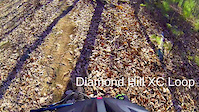
Starts to the left off of the two track climb following Micro Steez. Climbs up a small hill then descends shortly through some well made berms, crosses the Smilov Sneak then climbs back up the hill crossing the Smilov sneak again further up eventually turning into a two track climb that brings you to the top of the DH trails and puts you onto Rhody-Flow if you are following the white arrow loop.

Local Trail Association
Traditionally Indigenous Territory

Recent Activity on Trail

Past Week
  • 4 rides
  • 6 miles average
6 Months
  • 29 rides
  • 7 miles avg distance
All
  • 745 rides
  • Last: Jun 16, 2026
c1c2c3c4
January
February
March
April
May
June
July
August
September
October
November
December
update trails status or condition

Tastey Berms Trail Reports

statusdatedescription
Aug 13, 2023 @ 10:16am
Aug 13, 2023
Aug 31, 2020 @ 2:49pm
Aug 31, 2020
Dec 27, 2019 @ 8:17am
Dec 27, 2019
Sep 27, 2018 @ 1:14pm
Sep 27, 2018
Large tree down across trail, blocking trail, made natural log ramp over. Cleared branches. Add mustard and your good to go.
Aug 19, 2018 @ 5:37am
Aug 19, 2018
more »
Status:
on Aug 13, 2023
Dry
Avg: 3.99 (5 votes)
Your vote: 0

view (2,890)
close
3D
Trail Conditions
  • Unknown
  • Snow Groomed
  • Snow Packed
  • Snow Covered
  • Snow Cover Partial
  • Freeze/thaw Cycle
  • Icy
  • Prevalent Mud
  • Wet
  • Variable
  • Ideal
  • Dry
  • Very Dry
Trail Flow (Ridden Direction)
Trailforks scans users ridelogs to determine the most popular direction each trail is ridden. A good flowing trail network will have most trails flowing in a single direction according to their intension.
The colour categories are based on what percentage of riders are riding a trail in its intended direction.
  • > 96%
  • > 90%
  • > 80%
  • > 70%
  • > 50%
  • < 50%
  • bi-directional trail
  • no data
Trail Last Ridden
Trailforks scans ridelogs to determine the last time a trail was ridden.
  • < 2 days
  • < 1 week
  • < 2 weeks
  • < 1 month
  • < 6 months
  • > 6 months
Trail Ridden Direction
The intended direction a trail should be ridden.
  • Downhill Only
  • Downhill Primary
  • Both Directions
  • Uphill Primary
  • Uphill Only
  • One Direction
Contribute Details
Colors indicate trail is missing specified detail.
  • Description
  • Photos
  • Description & Photos
  • Videos
Trail Popularity ?
Trailforks scans ridelogs to determine which trails are ridden the most in the last 9 months. Trails are compared with nearby trails in the same city region with a possible 25 colour shades. Think of this as a heatmap, more rides = more kinetic energy = warmer colors.
  • most popular
  • popular
  • less popular
  • not popular
ATV/ORV/OHV Filter
Max Vehicle Width
inches
US Cell Coverage
Legend
cell carrier legend

Radar Time
Activity Recordings
Trailforks uses anonymized public activity data. ?
Activity Recordings
Trailforks uses anonymized public activity data. ?
Personal Heatmap
Activity Types
all / none
Options
2
Date range month
Winter Trails
Warning A routing network for winter maps does not exist. Selecting trails using the winter trails layer has been disabled.
Missing Trails
Most Popular
Least Popular
Trails are colored based on popularity. The more popular a trail is, the more red. Less popular trails trend towards green.
Jump Magnitude Heatmap
Heatmap of where riders jump on trails. Zoom in to see individual jumps, click circles to view jump details.
BC Backroad Status

Service Road Atlas is a free to use, community-driven service for viewing and creating reports on the numerous back-country service roads around B.C. and Alberta.

map legend
Slope Aspect
Direction the slope faces
Flat N NE E SE S SW W NW
Trails Deemphasized
Trails are shown in grey.
disable
Only show trails with no bike usage.
Enable
Suggested Layers
Based on selected activity type

    Save the current map location and zoom level as your default home location whenever this page is loaded.

    Save
        Directions to tastey-berms trailhead (42.001100, -71.430230)

        Photos

        No photos have been added for Tastey Berms yet, add a photo.

        Videos

        1 more »
        DHill XC Loop
        5:37 | 687 | Nov 26, 2014 , Cumberland

        Routes with this trail

        3.7 9 miles 1,039 ft 18
        This the the full XC loop for the 2023 DiHi Fun Ride
        5 miles 900 ft 12
        This is the "enduro" loop for the 2023 Fun Ride
        3.0 6 miles 802 ft 14
        A little bit of everything for everyone

        2 Reviews & Comments


        We hope you've been enjoying Trailforks!

        Create a FREE account to view trail comments and much more.

        Frequently Asked Questions About Tastey Berms

        Where is Tastey Berms located?
        Tastey Berms is located in Diamond Hill, Cumberland, Rhode Island, United States. It is part of the Diamond Hill trail network. The trailhead is located at coordinates 42.0011, -71.43023.
        How hard is Tastey Berms?
        Tastey Berms is rated as Blue difficulty. The physical rating is Moderate. The average grade is 2.6%.
        What is the elevation gain for Tastey Berms?
        Tastey Berms has 142 ft of elevation gain. The trail has 61 ft of elevation descent. The elevation ranges from 329 ft to 453 ft.
        Is Tastey Berms a point to point trail?
        Yes, Tastey Berms is a point to point trail. The direction is Downhill Only. The trail type is singletrack.

        Hit the Trail

        Open in App

        Get this trail on your phone instantly.
        open trail in app

        Download Trail

        Save to wishlist, Garmin & download.
        save the trail

        Find Related Routes

        Find routes and users activities that include this trail.
        find routes for this trail

        You must enter a description before submitting.