more stats
3.1 miles
Distance
129 ft
Climb
-2,448 ft
Descent
00:24:16
Avg time
-2,319 ft
Altitude change
303 ft
Altitude min
2,623 ft
Altitude max
2,622 ft
Altitude start
305 ft
Altitude end
-14%
Grade
-80.2%
Grade max
34.1%
Grade min
1,591 ft
Distance climb
3 miles
Distance down
587 ft
Distance flat
00:24:16
Avg time

Te Ara Koa Details

  • Activities
    • Mountain Bike
    • E-Bike
  • Riding Area
  • Difficulty Rating
  • Voted Difficulty
    Black Diamond (9 votes)
  • Local Popularity
    80 in Mountain Biking [+]
    • 65 in E-Biking
  • Global Ranking
    #3402 in Mountain Biking [+]
    • #2747 in E-Biking
  • Trail Type
    Singletrack
  • Bike Type
    DH, AM
  • Physical Rating
    Moderate
  • Trail Visibility
    Always easy to follow
  • eBike Allowed
    Yes up to Class 1
  • TTFs on Trail
    Rock Garden
  • Ride in Rain
    Yes
  • Year Opened
    2017

Te Ara Koa (translated as "Trail to Happiness") opened in October 2017 after thousands of hours of graft from the Nelson Mountain Bike Club's volunteer builders.

5.1km long, dropping 700m, through native bush. It's hand built pure singletrack with plenty of small natural features to keep you on your toes. The trail starts on an easy gradient but is made challenging by a carpet of ancient tree roots and plenty of off camber. After the first 1000m it gets into a well-benched traverse and the flow comes at you thick and fast. After 3.5km you cross the historic Dun Mountain Railway trail, after which Te Ara Koa keeps on going at the same grade right down to Brook Street, just 10 minutes from Nelson CBD.

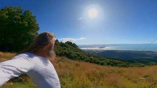
If you are fit and eager you can tick off the climb and descent in under 2hrs, but most people will take 2.30/3hrs at a steady pace with a long stop at the top to enjoy the incredible views over Tasman Bay to Kahurangi National Park and Mount Arthur.

The trail uses Ngati Koata and Nelson City Council land, who supported the build process. New trail grade in 2021

Access Info

Head up to the top of Fringed Hill from the Brook area in Nelson - the trail is signposted from the very top.

Trail Supporters

Recent Activity on Trail

Past Week
  • 0 rides
  •  
6 Months
  • 42 rides
  • 22.1 km avg distance
All
  • 222 rides
  • Last: Jun 23, 2026
c1c2c3c4
January
February
March
April
May
June
July
August
September
October
November
December
update trails status or condition

Te Ara Koa Trail Reports

statusdatedescription
May 30, 2026 @ 10:56am (Pacific/Auckland)
May 29, 2026
Quite a bit of of pig activity on the top section... Trail is ok, but might be good to get some hunters in
May 14, 2026 @ 10:44pm (Pacific/Auckland)
May 14, 2026
Perfect
Apr 22, 2026 @ 12:16pm (Pacific/Auckland)
Apr 21, 2026
Tree cleared. Little bits of pig rooting here and there in the mid section.
Apr 21, 2026 @ 10:06am (Pacific/Auckland)
Apr 20, 2026
tree down roughly half way
Mar 17, 2026 @ 4:44pm (Pacific/Auckland)
Mar 16, 2026
more »
Status:
on May 30, 2026
Ideal
Avg: 4.68 (32 votes)
Your vote: 0

view (2,409)
close
3D
Trail Conditions
  • Unknown
  • Snow Groomed
  • Snow Packed
  • Snow Covered
  • Snow Cover Partial
  • Freeze/thaw Cycle
  • Icy
  • Prevalent Mud
  • Wet
  • Variable
  • Ideal
  • Dry
  • Very Dry
Trail Flow (Ridden Direction)
Trailforks scans users ridelogs to determine the most popular direction each trail is ridden. A good flowing trail network will have most trails flowing in a single direction according to their intension.
The colour categories are based on what percentage of riders are riding a trail in its intended direction.
  • > 96%
  • > 90%
  • > 80%
  • > 70%
  • > 50%
  • < 50%
  • bi-directional trail
  • no data
Trail Last Ridden
Trailforks scans ridelogs to determine the last time a trail was ridden.
  • < 2 days
  • < 1 week
  • < 2 weeks
  • < 1 month
  • < 6 months
  • > 6 months
Trail Ridden Direction
The intended direction a trail should be ridden.
  • Downhill Only
  • Downhill Primary
  • Both Directions
  • Uphill Primary
  • Uphill Only
  • One Direction
Contribute Details
Colors indicate trail is missing specified detail.
  • Description
  • Photos
  • Description & Photos
  • Videos
Trail Popularity ?
Trailforks scans ridelogs to determine which trails are ridden the most in the last 9 months. Trails are compared with nearby trails in the same city region with a possible 25 colour shades. Think of this as a heatmap, more rides = more kinetic energy = warmer colors.
  • most popular
  • popular
  • less popular
  • not popular
ATV/ORV/OHV Filter
Max Vehicle Width
inches
US Cell Coverage
Legend
cell carrier legend

Radar Time
Activity Recordings
Trailforks uses anonymized public activity data. ?
Activity Recordings
Trailforks uses anonymized public activity data. ?
Personal Heatmap
Activity Types
all / none
Options
2
Date range month
Winter Trails
Warning A routing network for winter maps does not exist. Selecting trails using the winter trails layer has been disabled.
Missing Trails
Most Popular
Least Popular
Trails are colored based on popularity. The more popular a trail is, the more red. Less popular trails trend towards green.
Jump Magnitude Heatmap
Heatmap of where riders jump on trails. Zoom in to see individual jumps, click circles to view jump details.
BC Backroad Status

Service Road Atlas is a free to use, community-driven service for viewing and creating reports on the numerous back-country service roads around B.C. and Alberta.

map legend
Slope Aspect
Direction the slope faces
Flat N NE E SE S SW W NW
Trails Deemphasized
Trails are shown in grey.
disable
Only show trails with no bike usage.
Enable
Suggested Layers
Based on selected activity type

    Save the current map location and zoom level as your default home location whenever this page is loaded.

    Save
        Directions to te-ara-koa trailhead (-41.310730, 173.316650)

        Photos

        62 more »
        560 |
        Feb 15, 2019 @ 9:53pm
        Feb 15, 2019
        368 |
        Jun 30, 2018 @ 2:00am
        Jun 30, 2018
        78 |
        Jan 11, 2021 @ 9:26pm
        Jan 11, 2021
        93 |
        Jan 11, 2021 @ 9:26pm
        Jan 11, 2021

        Videos

        13 more »
        youtuber The trail that broke my ribs...
        3:31 | 357 | Mar 8, 2023 , Nelson
        youtuber Te Ara Koa | Nelson's Longest Singletrack?
        16:54 | 689 | Mar 8, 2022 , Nelson
        youtuber Jungle Boogie - Te Ara Koa
        8:36 | 1188 | Feb 1, 2019 , Nelson
        youtuber A beautiful piece of singletrail: Te Ara Koa,...
        23:19 | 1153 | Apr 13, 2018 , Nelson

        Routes with this trail

        33 miles 10,816 ft 12
        A visitors route to show some of the best that's available on Fringed Hill. Catch a shuttle for the first...
        5.0 26 miles 5,958 ft 62 Point to Point Race
        Aorere Enduro - Asia - Pacific Continental Round 1 Day 2
        17 miles 4,926 ft 5 Race
        Aorere Junior Enduro V1 April2024

        15 Reviews & Comments


        We hope you've been enjoying Trailforks!

        Create a FREE account to view trail comments and much more.

        • By NMTBCTF Pro NMTBC & contributors
        • #104648 - 19,676 views

        Frequently Asked Questions About Te Ara Koa

        Where is Te Ara Koa located?
        Te Ara Koa is located in Fringed Hill Nelson, Nelson, New Zealand. It is part of the Fringed Hill Nelson trail network. The trailhead is located at coordinates -41.31073, 173.31665.
        How hard is Te Ara Koa?
        Te Ara Koa is rated as Black Diamond difficulty. The physical rating is Moderate. The average grade is 14%.
        What is the elevation gain for Te Ara Koa?
        Te Ara Koa has 129 ft of elevation gain. The trail has 2,448 ft of elevation descent. The elevation ranges from 303 ft to 2,623 ft.
        How long is Te Ara Koa?
        Te Ara Koa is 3.1 miles long. The trail type is singletrack.

        Hit the Trail

        Open in App

        Get this trail on your phone instantly.
        open trail in app

        Download Trail

        Save to wishlist, Garmin & download.
        save the trail

        Find Related Routes

        Find routes and users activities that include this trail.
        find routes for this trail

        You must enter a description before submitting.