more stats
4,226 ft
Distance
28 ft
Climb
-164 ft
Descent
00:04:13
Avg time
-136 ft
Altitude change
558 ft
Altitude min
705 ft
Altitude max
693 ft
Altitude start
558 ft
Altitude end
-3.216%
Grade
-7.301%
Grade max
13.43%
Grade min
675 ft
Distance climb
3,306 ft
Distance down
245 ft
Distance flat
00:04:13
Avg time

Telegraph Row Details

  • Activities
    • Mountain Bike
    • Hike
    • Trail Running
  • Riding Area
    Surrey Hills
    Dorking
  • Difficulty Rating
  • Local Popularity
    95 in Mountain Biking [+]
    • 35 in Trail Running
    • 5 in Hiking
  • Global Ranking
    #5268 in Mountain Biking [+]
    • #127132 in Trail Running
    • #50410 in Hiking
  • Trail Type
    Singletrack
  • Bike Type
    XC
  • Direction
    Downhill Primary
    Popular Direction Shown
  • Climb Difficulty
    Green
  • Physical Rating
    Easy
  • Season
    May-Sept
  • Dogs Allowed
    Yes
  • eBike Allowed
    Yes up to Class 1
  • Land Owner

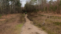
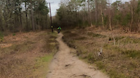
Though it's popular to coast down the bridleway and pick this trail up halfway; this trail shares the start of 'Secret Squirrel' and misses the first uphill slog of the trail, whilst retains the early more tricky XC part.

Access Info

Roll slightly downhill from the exit of Yoghurt Pots (https://www.trailforks.com/trails/yogurt-pots/) then bare left on the bridleway, then take the trail on the right just after the crest of the hill.

This trail is unsanctioned.

Recent Activity on Trail

Past Week
  • 10 rides
  • 17 miles average
6 Months
  • 130 rides
  • 15 miles avg distance
All
  • 1,042 rides
  • Last: Jun 19, 2026
c1c2c3c4
January
February
March
April
May
June
July
August
September
October
November
December
update trails status or condition

Telegraph Row Trail Reports

Status:
on Jun 9, 2026
Ideal
Avg: 4 (23 votes)
Your vote: 0

view (8,193)
close
3D
Trail Conditions
  • Unknown
  • Snow Groomed
  • Snow Packed
  • Snow Covered
  • Snow Cover Partial
  • Freeze/thaw Cycle
  • Icy
  • Prevalent Mud
  • Wet
  • Variable
  • Ideal
  • Dry
  • Very Dry
Trail Flow (Ridden Direction)
Trailforks scans users ridelogs to determine the most popular direction each trail is ridden. A good flowing trail network will have most trails flowing in a single direction according to their intension.
The colour categories are based on what percentage of riders are riding a trail in its intended direction.
  • > 96%
  • > 90%
  • > 80%
  • > 70%
  • > 50%
  • < 50%
  • bi-directional trail
  • no data
Trail Last Ridden
Trailforks scans ridelogs to determine the last time a trail was ridden.
  • < 2 days
  • < 1 week
  • < 2 weeks
  • < 1 month
  • < 6 months
  • > 6 months
Trail Ridden Direction
The intended direction a trail should be ridden.
  • Downhill Only
  • Downhill Primary
  • Both Directions
  • Uphill Primary
  • Uphill Only
  • One Direction
Contribute Details
Colors indicate trail is missing specified detail.
  • Description
  • Photos
  • Description & Photos
  • Videos
Trail Popularity ?
Trailforks scans ridelogs to determine which trails are ridden the most in the last 9 months. Trails are compared with nearby trails in the same city region with a possible 25 colour shades. Think of this as a heatmap, more rides = more kinetic energy = warmer colors.
  • most popular
  • popular
  • less popular
  • not popular
ATV/ORV/OHV Filter
Max Vehicle Width
inches
US Cell Coverage
Legend
cell carrier legend

Radar Time
Activity Recordings
Trailforks uses anonymized public activity data. ?
Activity Recordings
Trailforks uses anonymized public activity data. ?
Personal Heatmap
Activity Types
all / none
Options
2
Date range month
Winter Trails
Warning A routing network for winter maps does not exist. Selecting trails using the winter trails layer has been disabled.
Missing Trails
Most Popular
Least Popular
Trails are colored based on popularity. The more popular a trail is, the more red. Less popular trails trend towards green.
Jump Magnitude Heatmap
Heatmap of where riders jump on trails. Zoom in to see individual jumps, click circles to view jump details.
BC Backroad Status

Service Road Atlas is a free to use, community-driven service for viewing and creating reports on the numerous back-country service roads around B.C. and Alberta.

map legend
Slope Aspect
Direction the slope faces
Flat N NE E SE S SW W NW
Trails Deemphasized
Trails are shown in grey.
disable
Only show trails with no bike usage.
Enable
Suggested Layers
Based on selected activity type

    Save the current map location and zoom level as your default home location whenever this page is loaded.

    Save
        Directions to telegraph-row trailhead (51.181657, -0.419090)

        Photos

        5 more »
        50 |
        Dec 13, 2025 @ 11:51pm
        Dec 13, 2025
        190 |
        Sep 12, 2021 @ 2:30pm
        Sep 12, 2021
        188 |
        Dec 31, 2019 @ 2:14am
        Dec 31, 2019
        197 |
        Oct 8, 2017 @ 1:15am
        Oct 8, 2017

        Videos

        3 more »
        OTB on Telegraph, Surrey hills
        0:16 | 403 | Feb 18, 2022 , Dorking
        Mate falls of on telegraph @ Surrey hills
        0:16 | | Feb 17, 2022 , Dorking
        Misty Mountain Hop
        4:41 | 737 | Dec 27, 2017 , Dorking

        Trail Lists

        Routes with this trail

        3.3 18 miles 2,279 ft 13
        A 19 Mile ride around Surrey Hills taking in some of the best bits... including 2 visits to Peaslake...
        3.0 12 miles 1,493 ft 7 Loop
        A ride that turned out pretty cool imported from Strava.
        2.7 15 miles 1,673 ft 11
        A great ride around the Surrey Hills from Holmbury YHA out to Pitch Hill and back

        2 Reviews & Comments


        We hope you've been enjoying Trailforks!

        Create a FREE account to view trail comments and much more.

        • #34297 - 5,858 views

        Frequently Asked Questions About Telegraph Row

        Where is Telegraph Row located?
        Telegraph Row is located in Surrey Hills, Dorking, United Kingdom. It is part of the Surrey Hills trail network. The trailhead is located at coordinates 51.18166, -0.41909.
        How hard is Telegraph Row?
        Telegraph Row is rated as Blue difficulty. The physical rating is Easy. The average grade is 3.216%. The climb difficulty is rated Green.
        What is the elevation gain for Telegraph Row?
        Telegraph Row has 28 ft of elevation gain. The trail has 164 ft of elevation descent. The elevation ranges from 558 ft to 705 ft.
        Is Telegraph Row a point to point trail?
        Telegraph Row is not a point to point trail. The direction is Downhill Primary. The trail type is singletrack.

        Hit the Trail

        Open in App

        Get this trail on your phone instantly.
        open trail in app

        Download Trail

        Save to wishlist, Garmin & download.
        save the trail

        Find Related Routes

        Find routes and users activities that include this trail.
        find routes for this trail

        You must enter a description before submitting.