more stats
2.6 miles
Distance
250 ft
Climb
-1,154 ft
Descent
01:17:42
Avg time
-904 ft
Altitude change
5,872 ft
Altitude min
6,847 ft
Altitude max
6,776 ft
Altitude start
5,873 ft
Altitude end
-6.5%
Grade
-36.9%
Grade max
52.5%
Grade min
2,451 ft
Distance climb
2 miles
Distance down
1,102 ft
Distance flat
01:17:42
Avg time

Telephone Trail Details

  • Activities
    • Mountain Bike
    • Horse
    • Hike
    • Trail Running
  • Riding Area
  • Ref Number
    #192
  • Difficulty Rating
  • Local Popularity
    70 in Mountain Biking [+]
    • 5 in Trail Running
    • 85 in Hiking
    • 5 in Horseback
  • Global Ranking
    #90446 in Mountain Biking [+]
    • #240367 in Trail Running
    • #57193 in Hiking
  • Hiking SAC Scale
    T2 Mountain Hiking
  • Trail Type
    Singletrack
  • Bike Type
    DH, AM, XC
  • Direction
    Downhill Primary
  • Climb Difficulty
    Black Diamond
  • Physical Rating
    Extreme
  • Trail Visibility
    Always easy to follow
  • Dogs Allowed
    Yes
  • eBike Allowed
  • Land Owner
    https://www.fs.usda.gov/recarea/tonto/specialplaces/recarea?recid=35343&actid=37

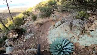
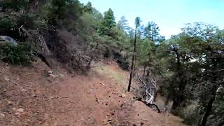
The upper portion of the telephone trail Has been restored. This is one of the more mellow sections of trail on the mountain. The majority of the top section is in a Pine Forest and survived the Telegraph Fire without major burns. This trail has a little bit of climbing in the first mile but then quickly turns downward all the way into Icehouse. Combine this trail with a start at the top of Ferndale then rip upper Sixer down to Telephone taking it the rest of the way to the CCC lot. This is a great route to enjoy this pines to chapparal experience that is Pinal.

Trail Supporters
Local Trail Association
Traditionally Indigenous Territory

Recent Activity on Trail

Past Week
  • 0 rides
  •  
6 Months
  • 1 rides
  • 31 miles avg distance
All
  • 16 rides
  • Last: May 2, 2026
c1c2c3c4
January
February
March
April
May
June
July
August
September
October
November
December
update trails status or condition

Telephone Trail Trail Reports

statusdatedescription
May 16, 2026 @ 5:15pm (America/Phoenix)
May 16, 2026
all clear. Use this trail to pedal up to six shooter after icehouse or is a fun DH from six shooter.
May 5, 2025 @ 5:14pm
May 5, 2025
reporter
Jan 11, 2025 @ 5:59pm
Jan 11, 2025
reporter Woo-hoo. Telephone restoration is done. There is still some trailwork to be done to make it super prime but its brushed open and for the most part...
Dec 15, 2024 @ 8:22am
Dec 15, 2024
reporter More work has been done on middle telephone. There is only .25 miles in the very middle of that section thats still very overgrown with Locust...
Dec 7, 2024 @ 5:27pm
Dec 7, 2024
reporter Another 1/3rd mile brushed open and cleaned up. Right now there is less than Top and lower are mint right now.
more »
Status:
on May 16, 2026
Dry
Avg: 3.77 (4 votes)
Your vote: 0

view (39)
close
3D
Trail Conditions
  • Unknown
  • Snow Groomed
  • Snow Packed
  • Snow Covered
  • Snow Cover Partial
  • Freeze/thaw Cycle
  • Icy
  • Prevalent Mud
  • Wet
  • Variable
  • Ideal
  • Dry
  • Very Dry
Trail Flow (Ridden Direction)
Trailforks scans users ridelogs to determine the most popular direction each trail is ridden. A good flowing trail network will have most trails flowing in a single direction according to their intension.
The colour categories are based on what percentage of riders are riding a trail in its intended direction.
  • > 96%
  • > 90%
  • > 80%
  • > 70%
  • > 50%
  • < 50%
  • bi-directional trail
  • no data
Trail Last Ridden
Trailforks scans ridelogs to determine the last time a trail was ridden.
  • < 2 days
  • < 1 week
  • < 2 weeks
  • < 1 month
  • < 6 months
  • > 6 months
Trail Ridden Direction
The intended direction a trail should be ridden.
  • Downhill Only
  • Downhill Primary
  • Both Directions
  • Uphill Primary
  • Uphill Only
  • One Direction
Contribute Details
Colors indicate trail is missing specified detail.
  • Description
  • Photos
  • Description & Photos
  • Videos
Trail Popularity ?
Trailforks scans ridelogs to determine which trails are ridden the most in the last 9 months. Trails are compared with nearby trails in the same city region with a possible 25 colour shades. Think of this as a heatmap, more rides = more kinetic energy = warmer colors.
  • most popular
  • popular
  • less popular
  • not popular
ATV/ORV/OHV Filter
Max Vehicle Width
inches
US Cell Coverage
Legend
cell carrier legend

Radar Time
Activity Recordings
Trailforks uses anonymized public activity data. ?
Activity Recordings
Trailforks uses anonymized public activity data. ?
Personal Heatmap
Activity Types
all / none
Options
2
Date range month
Winter Trails
Warning A routing network for winter maps does not exist. Selecting trails using the winter trails layer has been disabled.
Missing Trails
Most Popular
Least Popular
Trails are colored based on popularity. The more popular a trail is, the more red. Less popular trails trend towards green.
Jump Magnitude Heatmap
Heatmap of where riders jump on trails. Zoom in to see individual jumps, click circles to view jump details.
BC Backroad Status

Service Road Atlas is a free to use, community-driven service for viewing and creating reports on the numerous back-country service roads around B.C. and Alberta.

map legend
Slope Aspect
Direction the slope faces
Flat N NE E SE S SW W NW
Trails Deemphasized
Trails are shown in grey.
disable
Only show trails with no bike usage.
Enable
Suggested Layers
Based on selected activity type

    Save the current map location and zoom level as your default home location whenever this page is loaded.

    Save
        Directions to telephone-trail trailhead (33.292250, -110.820110)

        Photos

        49 more »
        29 |
        Jan 12, 2025 @ 3:35pm
        Jan 12, 2025
        30 |
        Jan 12, 2025 @ 3:35pm
        Jan 12, 2025
        27 |
        Jan 12, 2025 @ 3:35pm
        Jan 12, 2025
        25 |
        Jan 12, 2025 @ 3:34pm
        Jan 12, 2025

        Videos

        3 more »
        AZ MTB : Pinal Mountains : Mid + Lower...
        8:07 | 180 | Dec 16, 2024 , Globe
        AZ MTB : Pinal Mountains: Upper Telephone 2024
        3:13 | 80 | Jul 7, 2024 , Globe
        Pinal mountain Downhill :Freight train ,...
        10:07 | 230 | May 4, 2022 , Globe

        Routes with this trail

        5.0 7 miles 279 ft 4 Shuttled
        This is the longest single track route on the mountain! Ferndale is fun and flowy. Top of Six Shooter is a...
        10 miles 2,828 ft 4 Loop
        This Provides another loop option for those seeking to pedal up Pinal Mountain. and Upper provide nice...

        5 Reviews & Comments


        We hope you've been enjoying Trailforks!

        Create a FREE account to view trail comments and much more.

        • By schillingsworthTF Pro TRAILFORKS HTA & contributors
        • #19954 - 2,379 views

        Frequently Asked Questions About Telephone Trail

        Where is Telephone Trail located?
        Telephone Trail is located in Pinal Mountain Trail System, Globe, Arizona, United States. It is part of the Pinal Mountain Trail System trail network. The trailhead is located at coordinates 33.29225, -110.82011.
        How hard is Telephone Trail?
        Telephone Trail is rated as Black Diamond difficulty. The physical rating is Extreme. The average grade is 6.5%. The climb difficulty is rated Black Diamond.
        What is the elevation gain for Telephone Trail?
        Telephone Trail has 250 ft of elevation gain. The trail has 1,154 ft of elevation descent. The elevation ranges from 5,872 ft to 6,847 ft.
        Is Telephone Trail a point to point trail?
        Telephone Trail is not a point to point trail. The direction is Downhill Primary. The trail type is singletrack.

        Hit the Trail

        Open in App

        Get this trail on your phone instantly.
        open trail in app

        Download Trail

        Save to wishlist, Garmin & download.
        save the trail

        Find Related Routes

        Find routes and users activities that include this trail.
        find routes for this trail

        You must enter a description before submitting.