more stats
3.4 miles
Distance
264 ft
Climb
-734 ft
Descent
4,999 ft
High Point
-470 ft
Altitude change
4,525 ft
Altitude min
4,995 ft
Altitude start
4,524 ft
Altitude end
-2.6%
Grade
-26.4%
Grade max
24.9%
Grade min
5,220 ft
Distance climb
2 miles
Distance down
1,998 ft
Distance flat

Ten Years Gone Details

  • Activities
    • Mountain Bike
    • E-Bike
    • Winter Fat Bike
    • Hike
    • Trail Running
    • Snowshoe
    • Backcountry Ski
  • Riding Area
    Jumpingpound Creek
    Bragg Creek, Alberta
  • Difficulty Rating
  • Local Popularity
    100 in Mountain Biking [+]
    • 100 in E-Biking
    • 70 in Trail Running
    • 80 in Hiking
    • 5 in Snowshoeing
    • 5 in Backcountry Skiing
  • Global Ranking
    #2506 in Mountain Biking [+]
    • #72652 in Trail Running
    • #50999 in Hiking
    • #1632 in Snowshoeing
    • #601 in Backcountry Skiing
  • Hiking SAC Scale
    T1 Hiking
  • Trail Type
    Singletrack
  • Snow Grooming
    Backcountry
  • Bike Type
    AM, XC, Fat
  • Direction
    Both Directions[+]
    • Both Directions for E-Biking
    • Both Directions for Trail Running
    • Both Directions for Hiking
    • Both Directions for Snowshoeing
    • Both Directions for Backcountry Skiing
    • Both Directions for Winter Fat Biking
  • Climb Difficulty
    Blue
  • Physical Rating
    Moderate
  • Trail Visibility
    Always easy to follow
  • Dogs Allowed
    Yes
  • eBike Allowed
  • Year Opened
    2024
  • Land Owner
    Alberta Forestry and Parks

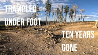
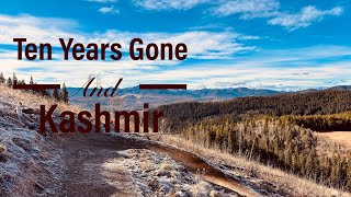
Fun & flowy singletrack with mellow grades that suit a broad range of riders and other users. It features many bermed turns, lots of rollers and a few small rock & root features.

The majority of the trail is machine-built and runs high along the hillside with regular viewpoints. The eastern end has over 1km of winding hand-built trail that climbs gradually but steadily to a hilltop known as Solo Hill.

Although it's bi-directional, many riders find climbing Kashmir easier and descending TYG (west-to-east) more fun. Together, these two trails form the eastern loop of the Jumped Up Loops project. Trampled Under Foot and Kashmir form the western loop.

Trail Supporters
Local Trail Association

Recent Activity on Trail

Past Week
  • 20 rides
  • 20.8 km average
6 Months
  • 223 rides
  • 16.6 km avg distance
All
  • 818 rides
  • Last: Jun 26, 2026
c1c2c3c4
January
February
March
April
May
June
July
August
September
October
November
December
update trails status or condition

Ten Years Gone Trail Reports

Status:
on Jun 13, 2026
Variable
Avg: 3.8 (9 votes)
Your vote: 0

view (2,308)
close
3D
Trail Conditions
  • Unknown
  • Snow Groomed
  • Snow Packed
  • Snow Covered
  • Snow Cover Partial
  • Freeze/thaw Cycle
  • Icy
  • Prevalent Mud
  • Wet
  • Variable
  • Ideal
  • Dry
  • Very Dry
Trail Flow (Ridden Direction)
Trailforks scans users ridelogs to determine the most popular direction each trail is ridden. A good flowing trail network will have most trails flowing in a single direction according to their intension.
The colour categories are based on what percentage of riders are riding a trail in its intended direction.
  • > 96%
  • > 90%
  • > 80%
  • > 70%
  • > 50%
  • < 50%
  • bi-directional trail
  • no data
Trail Last Ridden
Trailforks scans ridelogs to determine the last time a trail was ridden.
  • < 2 days
  • < 1 week
  • < 2 weeks
  • < 1 month
  • < 6 months
  • > 6 months
Trail Ridden Direction
The intended direction a trail should be ridden.
  • Downhill Only
  • Downhill Primary
  • Both Directions
  • Uphill Primary
  • Uphill Only
  • One Direction
Contribute Details
Colors indicate trail is missing specified detail.
  • Description
  • Photos
  • Description & Photos
  • Videos
Trail Popularity ?
Trailforks scans ridelogs to determine which trails are ridden the most in the last 9 months. Trails are compared with nearby trails in the same city region with a possible 25 colour shades. Think of this as a heatmap, more rides = more kinetic energy = warmer colors.
  • most popular
  • popular
  • less popular
  • not popular
ATV/ORV/OHV Filter
Max Vehicle Width
inches
US Cell Coverage
Legend
cell carrier legend

Radar Time
Activity Recordings
Trailforks uses anonymized public activity data. ?
Activity Recordings
Trailforks uses anonymized public activity data. ?
Personal Heatmap
Activity Types
all / none
Options
2
Date range month
Winter Trails
Warning A routing network for winter maps does not exist. Selecting trails using the winter trails layer has been disabled.
Missing Trails
Most Popular
Least Popular
Trails are colored based on popularity. The more popular a trail is, the more red. Less popular trails trend towards green.
Jump Magnitude Heatmap
Heatmap of where riders jump on trails. Zoom in to see individual jumps, click circles to view jump details.
BC Backroad Status

Service Road Atlas is a free to use, community-driven service for viewing and creating reports on the numerous back-country service roads around B.C. and Alberta.

map legend
Slope Aspect
Direction the slope faces
Flat N NE E SE S SW W NW
Trails Deemphasized
Trails are shown in grey.
disable
Only show trails with no bike usage.
Enable
Suggested Layers
Based on selected activity type

    Save the current map location and zoom level as your default home location whenever this page is loaded.

    Save
        Directions to ten-years-gone trailhead (51.050240, -114.752490)

        Photos

        35 more »
        106 |
        Oct 10, 2025 @ 4:28pm
        Oct 10, 2025
        90 |
        Oct 10, 2025 @ 4:27pm
        Oct 10, 2025
        83 |
        Aug 25, 2025 @ 5:55pm
        Aug 25, 2025
        74 |
        Aug 25, 2025 @ 5:55pm
        Aug 25, 2025

        Videos

        2 more »
        You Should Come Check Out These New Trails -...
        29:54 | 132 | Oct 13, 2025 , Bragg Creek
        Ten Years Gone
        7:24 | 555 | Feb 15, 2025 , Bragg Creek

        Routes with this trail

        5.0 10 miles 1,432 ft 5 Loop
        , and create the new 'Jumped Up Loops'. This figure-eight is the suggested way to get maximum...
        4.5 6 miles 801 ft 5 Loop
        Most riders find this to be the easiest and most fun way to ride the east loop ( & ) of the Jumped Up...
        5.0 9 miles 1,138 ft 4 Loop
        This route takes in the two core Jumped Up Loop trails in the shortest / fastest possible loop.

        8 Reviews & Comments


        We hope you've been enjoying Trailforks!

        Create a FREE account to view trail comments and much more.

        • By onecogpaulTF Pro BCT CMBA AEF & contributors
        • #793363 - 4,988 views

        Frequently Asked Questions About Ten Years Gone

        Where is Ten Years Gone located?
        Ten Years Gone is located in Jumpingpound Creek, Bragg Creek, Alberta, Canada. It is part of the Jumpingpound Creek trail network. The trailhead is located at coordinates 51.05024, -114.75249.
        How hard is Ten Years Gone?
        Ten Years Gone is rated as Blue difficulty. The physical rating is Moderate. The average grade is 2.6%. The climb difficulty is rated Blue.
        What is the elevation gain for Ten Years Gone?
        Ten Years Gone has 264 ft of elevation gain. The trail has 734 ft of elevation descent. The elevation ranges from 4,525 ft to 4,999 ft.
        Is Ten Years Gone a point to point trail?
        Ten Years Gone is not a point to point trail. The direction is Both Directions. The trail type is singletrack.

        Hit the Trail

        Open in App

        Get this trail on your phone instantly.
        open trail in app

        Download Trail

        Save to wishlist, Garmin & download.
        save the trail

        Find Related Routes

        Find routes and users activities that include this trail.
        find routes for this trail

        You must enter a description before submitting.