more stats
1.0 mile
Distance
7 ft
Climb
-604 ft
Descent
00:08:23
Avg time
-597 ft
Altitude change
263 ft
Altitude min
860 ft
Altitude max
860 ft
Altitude start
262 ft
Altitude end
-11%
Grade
-46.1%
Grade max
10.4%
Grade min
197 ft
Distance climb
4,652 ft
Distance down
581 ft
Distance flat
00:08:23
Avg time

Tenderfoot Details

  • Activities
    • Mountain Bike
    • Hike
    • Trail Running
  • Riding Area
    Mill Valley
    , California
  • Difficulty Rating
  • Voted Difficulty
    Black Diamond (6 votes)
  • Local Popularity
    85 in Mountain Biking [+]
    • 90 in Trail Running
    • 75 in Hiking
  • Global Ranking
    #40297 in Mountain Biking [+]
    • #594 in Trail Running
    • #37277 in Hiking
  • Trail Type
    Singletrack
  • Bike Type
    AM, XC
  • Direction
    Downhill Primary
  • Physical Rating
    Moderate
  • Trail Visibility
    Always easy to follow
  • Season
    All Year
  • Dogs Allowed
    Yes
  • eBike Allowed
  • Land Owner
    City of Mill Valley

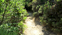
A Singletrack turning into a doubletrack that heads from Mountain Home Inn to downtown Mill Valley. Lots of hikers use it and expect to see a few bikers as well. Erosion is a large issue due to the lack of permits being issued for trail maintenance, so you may want to think twice before riding it in the wet (although it is doable). Erosion also creates large, unprotected drop-offs on the rider's left on some upper sections of the trail where it's all singletrack. There is a handful of optional (and at least rated black) shortcuts that one can take towards the lower section of the trail that cut down the slope instead of going along it like the rest of the trail. Upper section of trail has some features that are not optional that could be classified as black.

Access Info

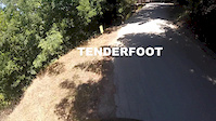
Once you are at Mountain Home Inn, you take the down sloping road next to the main building. You will descend around 2-5 minutes depending on your downhill speed and will see a generator/electrical box near the trail head. Although you might think you will be entering someone's backyard, this is the trail head.

Local Trail Association
Traditionally Indigenous Territory

Recent Activity on Trail

Past Week
  • 1 rides
  • 51 miles average
6 Months
  • 29 rides
  • 18 miles avg distance
All
  • 198 rides
  • Last: Jun 17, 2026
c1c2c3c4
January
February
March
April
May
June
July
August
September
October
November
December
Status:
on May 21, 2026
Variable
Avg: 4.14 (15 votes)
Your vote: 0

view (3,983)
close
3D
Trail Conditions
  • Unknown
  • Snow Groomed
  • Snow Packed
  • Snow Covered
  • Snow Cover Partial
  • Freeze/thaw Cycle
  • Icy
  • Prevalent Mud
  • Wet
  • Variable
  • Ideal
  • Dry
  • Very Dry
Trail Flow (Ridden Direction)
Trailforks scans users ridelogs to determine the most popular direction each trail is ridden. A good flowing trail network will have most trails flowing in a single direction according to their intension.
The colour categories are based on what percentage of riders are riding a trail in its intended direction.
  • > 96%
  • > 90%
  • > 80%
  • > 70%
  • > 50%
  • < 50%
  • bi-directional trail
  • no data
Trail Last Ridden
Trailforks scans ridelogs to determine the last time a trail was ridden.
  • < 2 days
  • < 1 week
  • < 2 weeks
  • < 1 month
  • < 6 months
  • > 6 months
Trail Ridden Direction
The intended direction a trail should be ridden.
  • Downhill Only
  • Downhill Primary
  • Both Directions
  • Uphill Primary
  • Uphill Only
  • One Direction
Contribute Details
Colors indicate trail is missing specified detail.
  • Description
  • Photos
  • Description & Photos
  • Videos
Trail Popularity ?
Trailforks scans ridelogs to determine which trails are ridden the most in the last 9 months. Trails are compared with nearby trails in the same city region with a possible 25 colour shades. Think of this as a heatmap, more rides = more kinetic energy = warmer colors.
  • most popular
  • popular
  • less popular
  • not popular
ATV/ORV/OHV Filter
Max Vehicle Width
inches
US Cell Coverage
Legend
cell carrier legend

Radar Time
Activity Recordings
Trailforks uses anonymized public activity data. ?
Activity Recordings
Trailforks uses anonymized public activity data. ?
Personal Heatmap
Activity Types
all / none
Options
2
Date range month
Winter Trails
Warning A routing network for winter maps does not exist. Selecting trails using the winter trails layer has been disabled.
Missing Trails
Most Popular
Least Popular
Trails are colored based on popularity. The more popular a trail is, the more red. Less popular trails trend towards green.
Jump Magnitude Heatmap
Heatmap of where riders jump on trails. Zoom in to see individual jumps, click circles to view jump details.
BC Backroad Status

Service Road Atlas is a free to use, community-driven service for viewing and creating reports on the numerous back-country service roads around B.C. and Alberta.

map legend
Slope Aspect
Direction the slope faces
Flat N NE E SE S SW W NW
Trails Deemphasized
Trails are shown in grey.
disable
Only show trails with no bike usage.
Enable
Suggested Layers
Based on selected activity type

    Save the current map location and zoom level as your default home location whenever this page is loaded.

    Save
        Directions to tenderfoot trailhead (37.907450, -122.571020)

        Photos

        6 more »
        419 |
        Dec 7, 2020 @ 4:09pm
        Dec 7, 2020
        289 |
        May 21, 2020 @ 10:40pm
        May 21, 2020
        486 |
        Mar 30, 2020 @ 11:47am
        Mar 30, 2020
        341 |
        Sep 30, 2018 @ 8:03pm
        Sep 30, 2018

        Videos

        2 more »
        Tam
        0:06 | 276 | Aug 9, 2017 , Mill Valley
        Tenderfoot with the new gopro hero4 session
        4:36 | 1000 | Jul 13, 2015 , Mill Valley

        Trail Lists

        Routes with this trail

        3.5 26 miles 3,747 ft 7 Loop
        This is a great route to tour you through some of the best mountain biking in the Mt Tam area. It starts...
        5.0 37 miles 6,581 ft 25 Loop
        A cross country route that gives terrain to build both fitness and skills.
        26 miles 3,748 ft 7 Loop
        This is a great route to tour you through some of the best mountain biking in the Mt Tam area. It starts...

        Trail Products

        11 Reviews & Comments


        We hope you've been enjoying Trailforks!

        Create a FREE account to view trail comments and much more.

        • By fmogan77 & contributors
        • #16721 - 8,902 views

        Frequently Asked Questions About Tenderfoot

        Where is Tenderfoot located?
        Tenderfoot is located in Mill Valley, California, United States. It is part of the Mill Valley trail network. The trailhead is located at coordinates 37.90745, -122.57102.
        How hard is Tenderfoot?
        Tenderfoot is rated as Blue difficulty. The physical rating is Moderate. The average grade is 11%.
        What is the elevation gain for Tenderfoot?
        Tenderfoot has 7 ft of elevation gain. The trail has 604 ft of elevation descent. The elevation ranges from 263 ft to 860 ft.
        Is Tenderfoot a point to point trail?
        Tenderfoot is not a point to point trail. The direction is Downhill Primary. The trail type is singletrack.

        Hit the Trail

        Open in App

        Get this trail on your phone instantly.
        open trail in app

        Download Trail

        Save to wishlist, Garmin & download.
        save the trail

        Find Related Routes

        Find routes and users activities that include this trail.
        find routes for this trail

        You must enter a description before submitting.