more stats
1.2 miles
Distance
-545 ft
Descent
00:09:54
Avg time
-546 ft
Altitude change
1,117 ft
Altitude min
1,663 ft
Altitude max
1,663 ft
Altitude start
1,115 ft
Altitude end
-8.4%
Grade
-33.7%
Grade max
4.8%
Grade min
135 ft
Distance climb
1 mile
Distance down
584 ft
Distance flat
00:09:54
Avg time

Terminator Details

  • Activities
    • Mountain Bike
    • E-Bike
    • Winter Fat Bike
    • Hike
    • Trail Running
  • Riding Area
  • Difficulty Rating
  • Voted Difficulty
    Blue (3 votes)
  • Local Popularity
    80 in Mountain Biking [+]
    • 80 in E-Biking
    • 75 in Trail Running
    • 85 in Hiking
  • Global Ranking
    #71660 in Mountain Biking [+]
    • #29830 in E-Biking
    • #54494 in Trail Running
    • #43985 in Hiking
  • Trail Type
    Singletrack
  • Bike Type
    DH, AM, XC, Fat
  • Direction
    Downhill Primary
    Popular Direction Shown
  • Climb Difficulty
    Black Diamond
  • Physical Rating
    Hard
  • Trail Visibility
    Always easy to follow
  • Dogs Allowed
    Yes
  • eBike Allowed
    Yes up to Class 1
  • Ride in Rain
    Yes
  • Land Owner
    BLM

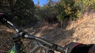
Terminator is mostly used as a downhill trail, and it has a high pucker factor. As one of the longest standing trails at Swasey, Terminator features variable terrain including narrow, steep, fast and loose rocks. There are a couple sharp switch backs and a couple tough off-camber turns. High potential for damaging your bike or yourself if you are unskilled, tired or not focused. This trail handles water very well, some would say the best conditions to ride it are during or shortly after a rainstorm. Some people (lunatics and hardcore folks) choose to ride up this trail, so be prepared to yield to uphill traffic. If you choose to ride up, hike, or run the trail, see if you can spot some cool rock walls used to support the trail tread near the halfway point - don't look for these while you're riding as you'll want all the focus you can get.

Local Trail Association
Traditionally Indigenous Territory

Recent Activity on Trail

Past Week
  • 1 rides
  • 17.2 km average
6 Months
  • 70 rides
  • 29.9 km avg distance
All
  • 355 rides
  • Last: Jun 18, 2026
c1c2c3c4
January
February
March
April
May
June
July
August
September
October
November
December
update trails status or condition

Terminator Trail Reports

statusdatedescription
Mar 7, 2026 @ 2:15pm (America/Boise)
Mar 7, 2026
Mar 11, 2025 @ 2:36pm
Mar 11, 2025
Dec 30, 2024 @ 3:30pm
Dec 30, 2024
reporter good shape
Dec 3, 2023 @ 10:49am
Dec 3, 2023
reporter Tree down at very start, rest of trail is great. Rut at bottom right hand turn is forming again.
Oct 27, 2022 @ 9:10am
Oct 27, 2022
more »
Status:
on Mar 7, 2026
Ideal
Avg: 3.85 (8 votes)
Your vote: 0

view (2,114)
close
3D
Trail Conditions
  • Unknown
  • Snow Groomed
  • Snow Packed
  • Snow Covered
  • Snow Cover Partial
  • Freeze/thaw Cycle
  • Icy
  • Prevalent Mud
  • Wet
  • Variable
  • Ideal
  • Dry
  • Very Dry
Trail Flow (Ridden Direction)
Trailforks scans users ridelogs to determine the most popular direction each trail is ridden. A good flowing trail network will have most trails flowing in a single direction according to their intension.
The colour categories are based on what percentage of riders are riding a trail in its intended direction.
  • > 96%
  • > 90%
  • > 80%
  • > 70%
  • > 50%
  • < 50%
  • bi-directional trail
  • no data
Trail Last Ridden
Trailforks scans ridelogs to determine the last time a trail was ridden.
  • < 2 days
  • < 1 week
  • < 2 weeks
  • < 1 month
  • < 6 months
  • > 6 months
Trail Ridden Direction
The intended direction a trail should be ridden.
  • Downhill Only
  • Downhill Primary
  • Both Directions
  • Uphill Primary
  • Uphill Only
  • One Direction
Contribute Details
Colors indicate trail is missing specified detail.
  • Description
  • Photos
  • Description & Photos
  • Videos
Trail Popularity ?
Trailforks scans ridelogs to determine which trails are ridden the most in the last 9 months. Trails are compared with nearby trails in the same city region with a possible 25 colour shades. Think of this as a heatmap, more rides = more kinetic energy = warmer colors.
  • most popular
  • popular
  • less popular
  • not popular
ATV/ORV/OHV Filter
Max Vehicle Width
inches
US Cell Coverage
Legend
cell carrier legend

Radar Time
Activity Recordings
Trailforks uses anonymized public activity data. ?
Activity Recordings
Trailforks uses anonymized public activity data. ?
Personal Heatmap
Activity Types
all / none
Options
2
Date range month
Winter Trails
Warning A routing network for winter maps does not exist. Selecting trails using the winter trails layer has been disabled.
Missing Trails
Most Popular
Least Popular
Trails are colored based on popularity. The more popular a trail is, the more red. Less popular trails trend towards green.
Jump Magnitude Heatmap
Heatmap of where riders jump on trails. Zoom in to see individual jumps, click circles to view jump details.
BC Backroad Status

Service Road Atlas is a free to use, community-driven service for viewing and creating reports on the numerous back-country service roads around B.C. and Alberta.

map legend
Slope Aspect
Direction the slope faces
Flat N NE E SE S SW W NW
Trails Deemphasized
Trails are shown in grey.
disable
Only show trails with no bike usage.
Enable
Suggested Layers
Based on selected activity type

    Save the current map location and zoom level as your default home location whenever this page is loaded.

    Save
        Directions to terminator-36246 trailhead (40.557810, -122.510500)

        Photos

        7 more »
        149 |
        Sep 19, 2021 @ 11:16pm
        Sep 19, 2021
        180 |
        Oct 12, 2020 @ 12:35pm
        Oct 12, 2020
        177 |
        Oct 12, 2020 @ 12:34pm
        Oct 12, 2020
        426 |
        Oct 15, 2018 @ 3:13pm
        Oct 15, 2018

        Videos

        3 more »
        Terminator Trail Redding California MTB
        12:01 | 357 | Nov 8, 2024 , Redding
        Terminator Trail with Schwarzenegger Quotes.
        8:52 | 364 | Jul 19, 2023 , Redding
        Mountain Biking Enticer & Terminator...
        25:09 | 629 | Dec 27, 2020 , Redding

        Routes with this trail

        5.0 34 miles 4,319 ft 14 Race
        The 2026 Lemurian Classic Expert & Pro course. We have eliminated the second time up , but instead...
        16 miles 2,112 ft 6 Loop
        This rock tech route from the Lower Parking Lot at Swasey Recreation can be done as a smaller or larger...
        10 miles 1,497 ft 4 Loop
        This Swasey Rec loop includes some very fun, but tech trails. Following is a basic trail to trail summary:...

        8 Reviews & Comments


        We hope you've been enjoying Trailforks!

        Create a FREE account to view trail comments and much more.

        Frequently Asked Questions About Terminator

        Where is Terminator located?
        Terminator is located in Mule Ridge and Swasey Recreation Area, Redding, California, United States. It is part of the Mule Ridge and Swasey Recreation Area trail network. The trailhead is located at coordinates 40.55781, -122.5105.
        How hard is Terminator?
        Terminator is rated as Black Diamond difficulty. The physical rating is Hard. The average grade is 8.4%. The climb difficulty is rated Black Diamond.
        What is the elevation gain for Terminator?
        The trail has 166 m of elevation descent. The elevation ranges from 340 m to 507 m.
        Is Terminator a point to point trail?
        Terminator is not a point to point trail. The direction is Downhill Primary. The trail type is singletrack.

        Hit the Trail

        Open in App

        Get this trail on your phone instantly.
        open trail in app

        Download Trail

        Save to wishlist, Garmin & download.
        save the trail

        Find Related Routes

        Find routes and users activities that include this trail.
        find routes for this trail

        You must enter a description before submitting.