more stats
1.4 miles
Distance
-901 ft
Descent
00:14:18
Avg time
-901 ft
Altitude change
126 ft
Altitude min
1,027 ft
Altitude max
1,027 ft
Altitude start
125 ft
Altitude end
-12.3%
Grade
-74.3%
Grade max
-2.1%
Grade min
1 mile
Distance down
00:14:18
Avg time

Termine 24 Details

  • Activities
    • Mountain Bike
  • Riding Area
    Castiglione Trail Park
    Castiglione della Pescaia
  • Difficulty Rating
  • Voted Difficulty
    Black Diamond (4 votes)
  • Local Popularity
    95 in Mountain Biking
  • Global Ranking
    #1509 in Mountain Biking
  • Trail Type
    Singletrack
  • Bike Type
    DH, AM
  • Direction
    Downhill Only
    Popular Direction Shown
  • Dogs Allowed
    Yes
  • eBike Allowed
    Yes up to Class 1
  • TTFs on Trail
    Berm, Drop, Jump, Rock Face, Rock Garden

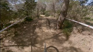
Natural, rough but flowy sigletract, very fast in parts with nice jumps in the lower section.

Recent Activity on Trail

Past Week
  • 2 rides
  • 7 miles average
6 Months
  • 19 rides
  • 13 miles avg distance
All
  • 227 rides
  • Last: Jun 17, 2026
c1c2c3c4
January
February
March
April
May
June
July
August
September
October
November
December
update trails status or condition

Termine 24 Trail Reports

Status:
on May 30, 2026
Dry
Avg: 4.55 (48 votes)
Your vote: 0

view (2,057)
close
3D
Trail Conditions
  • Unknown
  • Snow Groomed
  • Snow Packed
  • Snow Covered
  • Snow Cover Partial
  • Freeze/thaw Cycle
  • Icy
  • Prevalent Mud
  • Wet
  • Variable
  • Ideal
  • Dry
  • Very Dry
Trail Flow (Ridden Direction)
Trailforks scans users ridelogs to determine the most popular direction each trail is ridden. A good flowing trail network will have most trails flowing in a single direction according to their intension.
The colour categories are based on what percentage of riders are riding a trail in its intended direction.
  • > 96%
  • > 90%
  • > 80%
  • > 70%
  • > 50%
  • < 50%
  • bi-directional trail
  • no data
Trail Last Ridden
Trailforks scans ridelogs to determine the last time a trail was ridden.
  • < 2 days
  • < 1 week
  • < 2 weeks
  • < 1 month
  • < 6 months
  • > 6 months
Trail Ridden Direction
The intended direction a trail should be ridden.
  • Downhill Only
  • Downhill Primary
  • Both Directions
  • Uphill Primary
  • Uphill Only
  • One Direction
Contribute Details
Colors indicate trail is missing specified detail.
  • Description
  • Photos
  • Description & Photos
  • Videos
Trail Popularity ?
Trailforks scans ridelogs to determine which trails are ridden the most in the last 9 months. Trails are compared with nearby trails in the same city region with a possible 25 colour shades. Think of this as a heatmap, more rides = more kinetic energy = warmer colors.
  • most popular
  • popular
  • less popular
  • not popular
ATV/ORV/OHV Filter
Max Vehicle Width
inches
US Cell Coverage
Legend
cell carrier legend

Radar Time
Activity Recordings
Trailforks uses anonymized public activity data. ?
Activity Recordings
Trailforks uses anonymized public activity data. ?
Personal Heatmap
Activity Types
all / none
Options
2
Date range month
Winter Trails
Warning A routing network for winter maps does not exist. Selecting trails using the winter trails layer has been disabled.
Missing Trails
Most Popular
Least Popular
Trails are colored based on popularity. The more popular a trail is, the more red. Less popular trails trend towards green.
Jump Magnitude Heatmap
Heatmap of where riders jump on trails. Zoom in to see individual jumps, click circles to view jump details.
BC Backroad Status

Service Road Atlas is a free to use, community-driven service for viewing and creating reports on the numerous back-country service roads around B.C. and Alberta.

map legend
Slope Aspect
Direction the slope faces
Flat N NE E SE S SW W NW
Trails Deemphasized
Trails are shown in grey.
disable
Only show trails with no bike usage.
Enable
Suggested Layers
Based on selected activity type

    Save the current map location and zoom level as your default home location whenever this page is loaded.

    Save
        Directions to termine-24 trailhead (42.792180, 10.861560)

        Photos

        23 more »
        335 |
        Oct 6, 2021 @ 4:29am
        Oct 6, 2021
        44 |
        Jan 2, 2026 @ 2:13am
        Jan 2, 2026
        181 |
        Sep 7, 2023 @ 2:17am
        Sep 7, 2023
        160 |
        Sep 7, 2023 @ 2:17am
        Sep 7, 2023

        Videos

        10 more »
        youtuber Termine 24 - Castiglione della Pescaia
        6:09 | 455 | Mar 29, 2022 , Castiglione della Pescaia
        youtuber MTB Castiglione della Pescaia 16.04.2022...
        6:10 | 726 | Apr 18, 2022 , Castiglione della Pescaia
        TERMINE 24 | Maremma Trail POV – Castiglione...
        9:43 | 56 | Feb 7, 2026 , Castiglione della Pescaia
        TERMINE 24 mtb trail - Castiglione Trail Park...
        8:52 | 56 | Apr 14, 2025 , Castiglione della Pescaia

        Routes with this trail

        15 miles 3,415 ft 12
        Castiglione Trail Park caratterizzato dal suo panorama mozzafiato e percorsi tecnici e veloci

        12 Reviews & Comments


        We hope you've been enjoying Trailforks!

        Create a FREE account to view trail comments and much more.

        Frequently Asked Questions About Termine 24

        Where is Termine 24 located?
        Termine 24 is located in Castiglione Trail Park, Castiglione della Pescaia, Italy. It is part of the Castiglione Trail Park trail network. The trailhead is located at coordinates 42.79218, 10.86156.
        How hard is Termine 24?
        Termine 24 is rated as Red difficulty. The average grade is 12.3%.
        What is the elevation gain for Termine 24?
        The trail has 901 ft of elevation descent. The elevation ranges from 126 ft to 1,027 ft.
        Is Termine 24 a point to point trail?
        Yes, Termine 24 is a point to point trail. The direction is Downhill Only. The trail type is singletrack.

        Hit the Trail

        Open in App

        Get this trail on your phone instantly.
        open trail in app

        Download Trail

        Save to wishlist, Garmin & download.
        save the trail

        Find Related Routes

        Find routes and users activities that include this trail.
        find routes for this trail

        You must enter a description before submitting.