more stats
1.1 miles
Distance
156 ft
Climb
-165 ft
Descent
00:12:16
Avg time
-10 ft
Altitude change
3,123 ft
Altitude min
3,290 ft
Altitude max
3,290 ft
Altitude start
3,281 ft
Altitude end
-0.2%
Grade
-16.4%
Grade max
16.5%
Grade min
3,018 ft
Distance climb
2,562 ft
Distance down
374 ft
Distance flat
00:12:16
Avg time

The Chutes Details

  • Activities
    • Mountain Bike
    • Horse
    • Hike
    • Trail Running
  • Riding Area
  • Difficulty Rating
  • Local Popularity
    100 in Mountain Biking [+]
    • 5 in Trail Running
    • 5 in Hiking
    • 5 in Horseback
  • Global Ranking
    #3660 in Mountain Biking [+]
    • #129137 in Trail Running
    • #122125 in Hiking
  • Trail Type
    Singletrack
  • Bike Type
    XC
  • Direction
    Both Directions
    Popular Direction Shown
  • Climb Difficulty
    Blue
  • Physical Rating
    Moderate
  • eBike Allowed

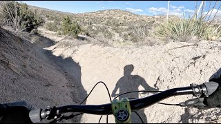
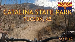
This trail is a series of very fun packed dirt chutes, rolling uphills, and a few optional small drops. The downhill is extremely fun and flowy but also fairly short. You will end in a sandy wash, cross this and the climbing trail will be to your left. The dirt in the chutes is prone to erosion, so after heavy rains or heavy use the trails tend to get rutted out.

Local Trail Association

Recent Activity on Trail

Past Week
  • 3 rides
  • 9 miles average
6 Months
  • 200 rides
  • 12 miles avg distance
All
  • 1,373 rides
  • Last: Jun 16, 2026
c1c2c3c4
January
February
March
April
May
June
July
August
September
October
November
December
update trails status or condition

The Chutes Trail Reports

Status:
on Apr 25, 2026
Dry
Avg: 4.22 (26 votes)
Your vote: 0

view (8,907)
close
3D
Trail Conditions
  • Unknown
  • Snow Groomed
  • Snow Packed
  • Snow Covered
  • Snow Cover Partial
  • Freeze/thaw Cycle
  • Icy
  • Prevalent Mud
  • Wet
  • Variable
  • Ideal
  • Dry
  • Very Dry
Trail Flow (Ridden Direction)
Trailforks scans users ridelogs to determine the most popular direction each trail is ridden. A good flowing trail network will have most trails flowing in a single direction according to their intension.
The colour categories are based on what percentage of riders are riding a trail in its intended direction.
  • > 96%
  • > 90%
  • > 80%
  • > 70%
  • > 50%
  • < 50%
  • bi-directional trail
  • no data
Trail Last Ridden
Trailforks scans ridelogs to determine the last time a trail was ridden.
  • < 2 days
  • < 1 week
  • < 2 weeks
  • < 1 month
  • < 6 months
  • > 6 months
Trail Ridden Direction
The intended direction a trail should be ridden.
  • Downhill Only
  • Downhill Primary
  • Both Directions
  • Uphill Primary
  • Uphill Only
  • One Direction
Contribute Details
Colors indicate trail is missing specified detail.
  • Description
  • Photos
  • Description & Photos
  • Videos
Trail Popularity ?
Trailforks scans ridelogs to determine which trails are ridden the most in the last 9 months. Trails are compared with nearby trails in the same city region with a possible 25 colour shades. Think of this as a heatmap, more rides = more kinetic energy = warmer colors.
  • most popular
  • popular
  • less popular
  • not popular
ATV/ORV/OHV Filter
Max Vehicle Width
inches
US Cell Coverage
Legend
cell carrier legend

Radar Time
Activity Recordings
Trailforks uses anonymized public activity data. ?
Activity Recordings
Trailforks uses anonymized public activity data. ?
Personal Heatmap
Activity Types
all / none
Options
2
Date range month
Winter Trails
Warning A routing network for winter maps does not exist. Selecting trails using the winter trails layer has been disabled.
Missing Trails
Most Popular
Least Popular
Trails are colored based on popularity. The more popular a trail is, the more red. Less popular trails trend towards green.
Jump Magnitude Heatmap
Heatmap of where riders jump on trails. Zoom in to see individual jumps, click circles to view jump details.
BC Backroad Status

Service Road Atlas is a free to use, community-driven service for viewing and creating reports on the numerous back-country service roads around B.C. and Alberta.

map legend
Slope Aspect
Direction the slope faces
Flat N NE E SE S SW W NW
Trails Deemphasized
Trails are shown in grey.
disable
Only show trails with no bike usage.
Enable
Suggested Layers
Based on selected activity type

    Save the current map location and zoom level as your default home location whenever this page is loaded.

    Save
        Directions to the-chutes trailhead (32.494710, -110.867620)

        Photos

        24 more »
        51 |
        Jan 28, 2026 @ 8:24pm
        Jan 28, 2026
        64 |
        Dec 8, 2025 @ 1:48pm
        Dec 8, 2025
        119 |
        Dec 2, 2023 @ 10:39am
        Dec 2, 2023
        151 |
        Jul 13, 2023 @ 4:29pm
        Jul 13, 2023

        Videos

        5 more »
        Chutes
        2:43 | 235 | Mar 31, 2024 , My City
        youtuber 50 Year Trail | Upper 50 Year | The Chutes |...
        9:06 | 420 | Apr 9, 2021 , My City
        Catalina State Park Tucson - MTB riding,...
        22:52 | 365 | Mar 7, 2021 , My City
        Tucson Road Trip 12-19-2020 | Chutes, 50...
        17:56 | 411 | Jan 4, 2021 , My City

        Routes with this trail

        4.1 12 miles 1,364 ft 22
        A good sized loop that grabs basically all the good stuff in the Golder Ranch/50 Year area. Has everything...
        4.7 13 miles 1,267 ft 18 Loop
        Loop starting at Golder TH, around the Chutes, up and Rattlesnake, then down "Around the Mountain"
        5.0 7 miles 684 ft 8
        This loop combines the Upper Trail with Middle Gate.

        9 Reviews & Comments


        We hope you've been enjoying Trailforks!

        Create a FREE account to view trail comments and much more.

        • By toddTF Pro Trailforks & contributors
        • #15419 - 6,811 views

        Frequently Asked Questions About The Chutes

        Where is The Chutes located?
        The Chutes is located in Coronado National Forest - Mt Lemmon, Arizona, United States. It is part of the Coronado National Forest - Mt Lemmon trail network. The trailhead is located at coordinates 32.49471, -110.86762.
        How hard is The Chutes?
        The Chutes is rated as Blue difficulty. The physical rating is Moderate. The average grade is 0.2%. The climb difficulty is rated Blue.
        What is the elevation gain for The Chutes?
        The Chutes has 156 ft of elevation gain. The trail has 165 ft of elevation descent. The elevation ranges from 3,123 ft to 3,290 ft.
        Is The Chutes a point to point trail?
        The Chutes is not a point to point trail. The direction is Both Directions. The trail type is singletrack.

        Hit the Trail

        Open in App

        Get this trail on your phone instantly.
        open trail in app

        Download Trail

        Save to wishlist, Garmin & download.
        save the trail

        Find Related Routes

        Find routes and users activities that include this trail.
        find routes for this trail

        You must enter a description before submitting.