more stats
3,051 ft
Distance
2 ft
Climb
-354 ft
Descent
00:03:49
Avg time
-351 ft
Altitude change
4,602 ft
Altitude min
4,953 ft
Altitude max
4,953 ft
Altitude start
4,603 ft
Altitude end
-11.5%
Grade
-28.4%
Grade max
2%
Grade min
36 ft
Distance climb
2,671 ft
Distance down
348 ft
Distance flat
00:03:49
Avg time

The Craig Details

  • Activities
    • Mountain Bike
    • E-Bike
  • Riding Area
    Valemount Bike Park
    Valemount, British Columbia
  • Difficulty Rating
  • Local Popularity
    95 in Mountain Biking [+]
    • 90 in E-Biking
  • Global Ranking
    #29131 in Mountain Biking [+]
    • #17358 in E-Biking
  • Trail Type
    Singletrack
  • Bike Type
    DH, AM
  • Direction
    Downhill Only
    Popular Direction Shown
  • Physical Rating
    Moderate
  • Trail Visibility
    Always easy to follow
  • Season
    May to October
  • eBike Allowed
    Yes up to Class 1
  • TTFs on Trail
    Berm, Bridge, Jump, Rock Garden
  • Year Opened
    2019

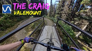
Beginning at the top of the road near the High Roller trailhead, "The Craig" is built as a hybrid of machine and hand building techniques with the intent of having a hand built feel to add variety to our trail system.

A significant amount of rock was brought into the site to create something truly unique to what we currently offer. The trail terminates at the Turducken staging area.

The trail is named after our fallen friend Everett Craig. Everett was a true supporter of the trail system and encouraged others to do the same whenever possible.

You will find a special feature on this trail that is just as unique as he was and we thank his family and friends for helping to make it happen. We hope you enjoy it.

Built by Andreas Thoni and Robson Design Build.

Trail Supporters

Bike Park

Recent Activity on Trail

Past Week
  • 12 rides
  • 18 miles average
6 Months
  • 32 rides
  • 16 miles avg distance
All
  • 822 rides
  • Last: Jun 20, 2026
c1c2c3c4
January
February
March
April
May
June
July
August
September
October
November
December
update trails status or condition

The Craig Trail Reports

Status:
on May 14, 2026
Avg: 4.65 (24 votes)
Your vote: 0

view (5,645)
close
3D
Trail Conditions
  • Unknown
  • Snow Groomed
  • Snow Packed
  • Snow Covered
  • Snow Cover Partial
  • Freeze/thaw Cycle
  • Icy
  • Prevalent Mud
  • Wet
  • Variable
  • Ideal
  • Dry
  • Very Dry
Trail Flow (Ridden Direction)
Trailforks scans users ridelogs to determine the most popular direction each trail is ridden. A good flowing trail network will have most trails flowing in a single direction according to their intension.
The colour categories are based on what percentage of riders are riding a trail in its intended direction.
  • > 96%
  • > 90%
  • > 80%
  • > 70%
  • > 50%
  • < 50%
  • bi-directional trail
  • no data
Trail Last Ridden
Trailforks scans ridelogs to determine the last time a trail was ridden.
  • < 2 days
  • < 1 week
  • < 2 weeks
  • < 1 month
  • < 6 months
  • > 6 months
Trail Ridden Direction
The intended direction a trail should be ridden.
  • Downhill Only
  • Downhill Primary
  • Both Directions
  • Uphill Primary
  • Uphill Only
  • One Direction
Contribute Details
Colors indicate trail is missing specified detail.
  • Description
  • Photos
  • Description & Photos
  • Videos
Trail Popularity ?
Trailforks scans ridelogs to determine which trails are ridden the most in the last 9 months. Trails are compared with nearby trails in the same city region with a possible 25 colour shades. Think of this as a heatmap, more rides = more kinetic energy = warmer colors.
  • most popular
  • popular
  • less popular
  • not popular
ATV/ORV/OHV Filter
Max Vehicle Width
inches
US Cell Coverage
Legend
cell carrier legend

Radar Time
Activity Recordings
Trailforks uses anonymized public activity data. ?
Activity Recordings
Trailforks uses anonymized public activity data. ?
Personal Heatmap
Activity Types
all / none
Options
2
Date range month
Winter Trails
Warning A routing network for winter maps does not exist. Selecting trails using the winter trails layer has been disabled.
Missing Trails
Most Popular
Least Popular
Trails are colored based on popularity. The more popular a trail is, the more red. Less popular trails trend towards green.
Jump Magnitude Heatmap
Heatmap of where riders jump on trails. Zoom in to see individual jumps, click circles to view jump details.
BC Backroad Status

Service Road Atlas is a free to use, community-driven service for viewing and creating reports on the numerous back-country service roads around B.C. and Alberta.

map legend
Slope Aspect
Direction the slope faces
Flat N NE E SE S SW W NW
Trails Deemphasized
Trails are shown in grey.
disable
Only show trails with no bike usage.
Enable
Suggested Layers
Based on selected activity type

    Save the current map location and zoom level as your default home location whenever this page is loaded.

    Save
        Directions to the-craig trailhead (52.848260, -119.223750)

        Photos

        12 more »
        202 |
        Sep 7, 2021 @ 10:35pm
        Sep 7, 2021
        326 |
        Feb 3, 2021 @ 6:35pm
        Feb 3, 2021
        376 |
        Feb 3, 2021 @ 6:35pm
        Feb 3, 2021
        476 |
        Feb 3, 2021 @ 6:35pm
        Feb 3, 2021

        Videos

        5 more »
        The Craig  - Valemount
        3:32 | 36 | Jan 9, 2026 , Valemount
        The Craig ◇ - Valemount Bike Park 3.0
        3:57 | 229 | Sep 22, 2022 , Valemount
        The Craig | Valemount | BC
        4:31 | 380 | Aug 2, 2022 , Valemount
        The Craig
        3:00 | 389 | Oct 9, 2020 , Valemount

        Routes with this trail

        4 miles 22 ft 4 Shuttled
        and are both iconic Valemount trails with very impressive bridge and 360 features. The ride finishes off...

        3 Reviews & Comments


        We hope you've been enjoying Trailforks!

        Create a FREE account to view trail comments and much more.

        • By andrewfromjasperTF Pro VARDA JPCA & contributors
        • #223081 - 3,149 views

        Frequently Asked Questions About The Craig

        Where is The Craig located?
        The Craig is located in Valemount Bike Park, Valemount, British Columbia, Canada. It is part of the Valemount Bike Park trail network. The trailhead is located at coordinates 52.84826, -119.22375.
        How hard is The Craig?
        The Craig is rated as Blue difficulty. The physical rating is Moderate. The average grade is 11.5%.
        What is the elevation gain for The Craig?
        The Craig has 1 m of elevation gain. The trail has 108 m of elevation descent. The elevation ranges from 1,403 m to 1,510 m.
        Is The Craig a point to point trail?
        Yes, The Craig is a point to point trail. The direction is Downhill Only. The trail type is singletrack.

        Hit the Trail

        Open in App

        Get this trail on your phone instantly.
        open trail in app

        Download Trail

        Save to wishlist, Garmin & download.
        save the trail

        Find Related Routes

        Find routes and users activities that include this trail.
        find routes for this trail

        You must enter a description before submitting.