This trail is permanently closed/decommissioned
more stats
2,805 ft
Distance
5 ft
Climb
-101 ft
Descent
00:02:41
Avg time
-96 ft
Altitude change
195 ft
Altitude min
291 ft
Altitude max
291 ft
Altitude start
194 ft
Altitude end
-3.4%
Grade
-21.7%
Grade max
3%
Grade min
591 ft
Distance climb
2,054 ft
Distance down
161 ft
Distance flat
00:02:41
Avg time

The Down Hill Details

  • Activities
    • Mountain Bike
    • E-Bike
  • Riding Area
    Maryvale Pines
    Traralgon
  • Difficulty Rating
  • Local Popularity
    95 in Mountain Biking [+]
    • 100 in E-Biking
  • Trail Type
    Singletrack
  • Bike Type
    XC
  • Climb Difficulty
    Blue
  • Physical Rating
    Moderate
  • Trail Visibility
    Always easy to follow
  • eBike Allowed
    Yes up to Class 1
  • TTFs on Trail
    Berm, Bridge, Drop, Jump, Gap Jump

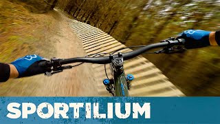
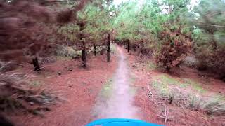
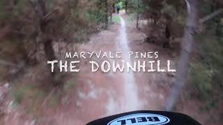
One of the original Pines descents. While the trail isn't always pointing down it does feature plenty of flow, great berms, rollers, a wooden wall ride, small drops and 2 small optional gap doubles.

This trail is unsanctioned.

Traditionally Indigenous Territory

Recent Activity on Trail

Past Week
  • 0 rides
  •  
6 Months
  • 8 rides
  • 15.0 km avg distance
All
  • 918 rides
  • Last: Mar 9, 2026
c1c2c3c4
January
February
March
April
May
June
July
August
September
October
November
December
update trails status or condition

The Down Hill Trail Reports

statusdatedescription
Mar 16, 2026 @ 1:37pm (Australia/Melbourne)
Mar 15, 2026
reporter Logged.
Oct 31, 2025 @ 8:22pm (Australia/Melbourne)
Oct 31, 2025
Maryvale Pines Trail Network will be closed to the public from November 1st 2025 through to April 2026 for HVP Harvest Operations. Please check...
Oct 24, 2025 @ 9:12am (Australia/Melbourne)
Oct 23, 2025
Maryvale Pines Trail Network will be closed to the public from November 1st 2025 through to April 2026 for HVP Harvest Operations. Please check...
May 25, 2025 @ 9:07am
May 25, 2025
Nov 3, 2024 @ 9:34am
Nov 3, 2024
more »
Status:
on Mar 16, 2026
Avg: 4.06 (8 votes)
Your vote: 0

view (9,848)
close
3D
Trail Conditions
  • Unknown
  • Snow Groomed
  • Snow Packed
  • Snow Covered
  • Snow Cover Partial
  • Freeze/thaw Cycle
  • Icy
  • Prevalent Mud
  • Wet
  • Variable
  • Ideal
  • Dry
  • Very Dry
Trail Flow (Ridden Direction)
Trailforks scans users ridelogs to determine the most popular direction each trail is ridden. A good flowing trail network will have most trails flowing in a single direction according to their intension.
The colour categories are based on what percentage of riders are riding a trail in its intended direction.
  • > 96%
  • > 90%
  • > 80%
  • > 70%
  • > 50%
  • < 50%
  • bi-directional trail
  • no data
Trail Last Ridden
Trailforks scans ridelogs to determine the last time a trail was ridden.
  • < 2 days
  • < 1 week
  • < 2 weeks
  • < 1 month
  • < 6 months
  • > 6 months
Trail Ridden Direction
The intended direction a trail should be ridden.
  • Downhill Only
  • Downhill Primary
  • Both Directions
  • Uphill Primary
  • Uphill Only
  • One Direction
Contribute Details
Colors indicate trail is missing specified detail.
  • Description
  • Photos
  • Description & Photos
  • Videos
Trail Popularity ?
Trailforks scans ridelogs to determine which trails are ridden the most in the last 9 months. Trails are compared with nearby trails in the same city region with a possible 25 colour shades. Think of this as a heatmap, more rides = more kinetic energy = warmer colors.
  • most popular
  • popular
  • less popular
  • not popular
ATV/ORV/OHV Filter
Max Vehicle Width
inches
US Cell Coverage
Legend
cell carrier legend

Radar Time
Activity Recordings
Trailforks uses anonymized public activity data. ?
Activity Recordings
Trailforks uses anonymized public activity data. ?
Personal Heatmap
Activity Types
all / none
Options
2
Date range month
Winter Trails
Warning A routing network for winter maps does not exist. Selecting trails using the winter trails layer has been disabled.
Missing Trails
Most Popular
Least Popular
Trails are colored based on popularity. The more popular a trail is, the more red. Less popular trails trend towards green.
Jump Magnitude Heatmap
Heatmap of where riders jump on trails. Zoom in to see individual jumps, click circles to view jump details.
BC Backroad Status

Service Road Atlas is a free to use, community-driven service for viewing and creating reports on the numerous back-country service roads around B.C. and Alberta.

map legend
Slope Aspect
Direction the slope faces
Flat N NE E SE S SW W NW
Trails Deemphasized
Trails are shown in grey.
disable
Only show trails with no bike usage.
Enable
Suggested Layers
Based on selected activity type

    Save the current map location and zoom level as your default home location whenever this page is loaded.

    Save
        Directions to the-down-hill trailhead (-38.191580, 146.469280)

        Photos

        1 more »
        60 |
        Jun 7, 2024 @ 3:39pm
        Jun 7, 2024

        Videos

        4 more »
        youtuber The Down Hill – Maryvale Pines MTB
        2:10 | 511 | Sep 11, 2022 , Traralgon
        The Downhill - Maryvale Pines mtb park
        2:22 | 607 | Apr 27, 2021 , Traralgon
        Maryvale Pines - The Down Hill
        2:19 | 242 | Feb 27, 2021 , Traralgon
        Downhill trail at Traralgon pines!
        2:45 | 1406 | Mar 8, 2020 , Traralgon

        Reviews / Comments

        No reviews yet, be the first to write a review or ask a question.
        Use trail reports to comment on trail conditions.


        We hope you've been enjoying Trailforks!

        Create a FREE account to view trail comments and much more.

        • #95313 - 1,614 views

        Frequently Asked Questions About The Down Hill

        Where is The Down Hill located?
        The Down Hill is located in Maryvale Pines, Traralgon, Australia. It is part of the Maryvale Pines trail network. The trailhead is located at coordinates -38.19158, 146.46928.
        How hard is The Down Hill?
        The Down Hill is rated as Blue difficulty. The physical rating is Moderate. The average grade is 3.4%. The climb difficulty is rated Blue.
        What is the elevation gain for The Down Hill?
        The Down Hill has 2 m of elevation gain. The trail has 31 m of elevation descent. The elevation ranges from 59 m to 89 m.
        How long is The Down Hill?
        The Down Hill is 855.0 m long. The trail type is singletrack.

        Hit the Trail

        Open in App

        Get this trail on your phone instantly.
        open trail in app

        Download Trail

        Save to wishlist, Garmin & download.
        save the trail

        Find Related Routes

        Find routes and users activities that include this trail.
        find routes for this trail

        You must enter a description before submitting.