more stats
4,633 ft
Distance
-301 ft
Descent
00:03:36
Avg time
-302 ft
Altitude change
6,422 ft
Altitude min
6,724 ft
Altitude max
6,724 ft
Altitude start
6,421 ft
Altitude end
-6.5%
Grade
-17.5%
Grade max
1.8%
Grade min
112 ft
Distance climb
4,324 ft
Distance down
197 ft
Distance flat
00:03:36
Avg time

The Drop Out Details

  • Activities
    • Mountain Bike
    • Adaptive Bike
  • Riding Area
    Glenwild
    Park City, Utah
  • Difficulty Rating
  • Voted Difficulty
    Blue (1 vote)
  • Local Popularity
    100 in Mountain Biking
  • Global Ranking
    #24592 in Mountain Biking
  • Trail Type
    Singletrack
  • Bike Type
    DH, AM, XC, Adaptive MTB
  • Direction
    Downhill Only
    Popular Direction Shown
  • Trail Visibility
    Always easy to follow
  • Dogs Allowed
    Yes
  • TTFs on Trail
    Berm, Bridge, Jump, Gap Jump, Roller Coaster

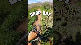
This trail has been completely redone over the summer of 2019. It now has much larger berms, more jumps, larger gap-able roller doubles, and small drops.

Adaptive Bike Info
aMTB Blue Rating: Intermediate features and steeper terrain.

Best adaptive DH in Bobs.

Trail is 34 - 40” wide. On camber - great burms. Technical rock gardens. Drops to flat. One sided jumps.

Traditionally Indigenous Territory

Recent Activity on Trail

Past Week
  • 12 rides
  • 14.3 km average
6 Months
  • 266 rides
  • 15.8 km avg distance
All
  • 2,163 rides
  • Last: Jun 10, 2026
c1c2c3c4
January
February
March
April
May
June
July
August
September
October
November
December
Status:
on May 20, 2026
Ideal
Avg: 4.32 (32 votes)
Your vote: 0

view (15,659)
close
3D
Trail Conditions
  • Unknown
  • Snow Groomed
  • Snow Packed
  • Snow Covered
  • Snow Cover Partial
  • Freeze/thaw Cycle
  • Icy
  • Prevalent Mud
  • Wet
  • Variable
  • Ideal
  • Dry
  • Very Dry
Trail Flow (Ridden Direction)
Trailforks scans users ridelogs to determine the most popular direction each trail is ridden. A good flowing trail network will have most trails flowing in a single direction according to their intension.
The colour categories are based on what percentage of riders are riding a trail in its intended direction.
  • > 96%
  • > 90%
  • > 80%
  • > 70%
  • > 50%
  • < 50%
  • bi-directional trail
  • no data
Trail Last Ridden
Trailforks scans ridelogs to determine the last time a trail was ridden.
  • < 2 days
  • < 1 week
  • < 2 weeks
  • < 1 month
  • < 6 months
  • > 6 months
Trail Ridden Direction
The intended direction a trail should be ridden.
  • Downhill Only
  • Downhill Primary
  • Both Directions
  • Uphill Primary
  • Uphill Only
  • One Direction
Contribute Details
Colors indicate trail is missing specified detail.
  • Description
  • Photos
  • Description & Photos
  • Videos
Trail Popularity ?
Trailforks scans ridelogs to determine which trails are ridden the most in the last 9 months. Trails are compared with nearby trails in the same city region with a possible 25 colour shades. Think of this as a heatmap, more rides = more kinetic energy = warmer colors.
  • most popular
  • popular
  • less popular
  • not popular
ATV/ORV/OHV Filter
Max Vehicle Width
inches
US Cell Coverage
Legend
cell carrier legend

Radar Time
Activity Recordings
Trailforks uses anonymized public activity data. ?
Activity Recordings
Trailforks uses anonymized public activity data. ?
Personal Heatmap
Activity Types
all / none
Options
2
Date range month
Winter Trails
Warning A routing network for winter maps does not exist. Selecting trails using the winter trails layer has been disabled.
Missing Trails
Most Popular
Least Popular
Trails are colored based on popularity. The more popular a trail is, the more red. Less popular trails trend towards green.
Jump Magnitude Heatmap
Heatmap of where riders jump on trails. Zoom in to see individual jumps, click circles to view jump details.
BC Backroad Status

Service Road Atlas is a free to use, community-driven service for viewing and creating reports on the numerous back-country service roads around B.C. and Alberta.

map legend
Slope Aspect
Direction the slope faces
Flat N NE E SE S SW W NW
Trails Deemphasized
Trails are shown in grey.
disable
Only show trails with no bike usage.
Enable
Suggested Layers
Based on selected activity type

    Save the current map location and zoom level as your default home location whenever this page is loaded.

    Save
        Directions to the-drop-out trailhead (40.743910, -111.552100)

        Photos

        6 more »
        167 |
        Sep 1, 2021 @ 11:51am
        Sep 1, 2021
        120 |
        May 6, 2020 @ 6:14pm
        May 6, 2020
        182 |
        May 6, 2020 @ 6:14pm
        May 6, 2020
        169 |
        Jul 13, 2019 @ 7:21am
        Jul 13, 2019

        Videos

        2 more »
        Drop Out - Park City, UT - MTB Trail...
        0:41 | 64 | Jul 3, 2025 , Park City
        The Dropout Full Trail Ride
        3:51 | 937 | Mar 21, 2021 , Park City
        Road to Acrylon / The Drop Out Trail / Park...
        6:15 | 575 | Jul 31, 2020 , Park City

        Trail Lists

        Routes with this trail

        13 miles 1,762 ft 4 Loop
        The Best Day Ride Series, brought to you by Park City Bike Racing and sponsored by Best Day Brewing, is...
        4 miles 573 ft 2
        A quick after work or early season loop. Great to get back into the things again or to go with a new rider...
        14 miles 1,915 ft 7 Loop
        Lollypop route from TH. Up Fink, , anti-clockwise on , back to , over to Dropout and down.

        11 Reviews & Comments


        We hope you've been enjoying Trailforks!

        Create a FREE account to view trail comments and much more.

        Nearby Trails

        • By toddTF Pro Trailforks & contributors
        • #11280 - 7,406 views

        Frequently Asked Questions About The Drop Out

        Where is The Drop Out located?
        The Drop Out is located in Glenwild, Park City, Utah, United States. It is part of the Glenwild trail network. The trailhead is located at coordinates 40.74391, -111.5521.
        How hard is The Drop Out?
        The Drop Out is rated as Blue difficulty. The average grade is 6.5%.
        What is the elevation gain for The Drop Out?
        The trail has 92 m of elevation descent. The elevation ranges from 1,957 m to 2,050 m.
        Is The Drop Out a point to point trail?
        Yes, The Drop Out is a point to point trail. The direction is Downhill Only. The trail type is singletrack.

        Hit the Trail

        Open in App

        Get this trail on your phone instantly.
        open trail in app

        Download Trail

        Save to wishlist, Garmin & download.
        save the trail

        Find Related Routes

        Find routes and users activities that include this trail.
        find routes for this trail

        You must enter a description before submitting.