more stats
3,701 ft
Distance
22 ft
Climb
-176 ft
Descent
00:08:11
Avg time
-154 ft
Altitude change
487 ft
Altitude min
641 ft
Altitude max
641 ft
Altitude start
489 ft
Altitude end
-4.2%
Grade
-29.9%
Grade max
15.8%
Grade min
325 ft
Distance climb
2,582 ft
Distance down
794 ft
Distance flat
00:08:11
Avg time

The Elf Details

  • Activities
    • Mountain Bike
    • E-Bike
  • Riding Area
    Balquhidder
    Strathyre
  • Difficulty Rating
  • Local Popularity
    40 in Mountain Biking [+]
    • 5 in E-Biking
  • Global Ranking
    #122673 in Mountain Biking [+]
    • #85662 in E-Biking
  • Trail Type
    Singletrack
  • Bike Type
    AM, XC
  • Direction
    Both Directions
    Popular Direction Shown
  • Climb Difficulty
    Blue
  • Physical Rating
    Moderate
  • Trail Visibility
    Sometimes hard to follow
  • Season
    Jan-Dec
  • Dogs Allowed
    Yes
  • eBike Allowed
    Yes up to Class 1
  • TTFs on Trail
    Berm
  • Year Opened
    2017
  • Land Owner
    Forestry And Land Scotland

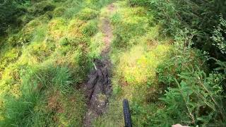
The Elf is a woodland footpath shared with walkers that serves nicely as a X-Country loop or warm-up trail ride before going up to the downhill singletrack trails on the north side of Balquhidder.
The Elf itself is a rolling singletrack that has an overall fall but has within it, both up and downhill sections. It is about 1.1k long which when combined with the uphill access using the B road climb up Glen Buckie makes a full loop of circa 1.7km - well suited to a short XC loop
On the Elf there are only a couple of slightly technical parts which would be approximately "red grade". Works ok in the wet since recent improvements.

Access Info

With Parking at Balquhidder Hall or the Kirk ride south up Glen Buckie and stop 30 metres before the cattle grid. The start of the trail is on your left.

This trail is unsanctioned.

Trail Supporters
  • past supporters

Recent Activity on Trail

Past Week
  • 0 rides
  •  
6 Months
  • 1 rides
  • 23 miles avg distance
All
  • 7 rides
  • Last: May 3, 2026
c1c2c3c4
January
February
March
April
May
June
July
August
September
October
November
December
update trails status or condition

The Elf Trail Reports

statusdatedescription
Jan 19, 2025 @ 4:00am
Jan 19, 2025
Fallen tree. Streams crossings. Trail lost in middle.
Nov 28, 2024 @ 11:43am
Nov 28, 2024
Apr 1, 2023 @ 3:07am
Apr 1, 2023
May 27, 2019 @ 2:36am
May 27, 2019
Dec 26, 2018 @ 2:26am
Dec 26, 2018
reporter some minor mud patches
more »
Status:
on Jan 19, 2025
Avg: 3.98 (1 votes)
Your vote: 0

view (61)
close
3D
Trail Conditions
  • Unknown
  • Snow Groomed
  • Snow Packed
  • Snow Covered
  • Snow Cover Partial
  • Freeze/thaw Cycle
  • Icy
  • Prevalent Mud
  • Wet
  • Variable
  • Ideal
  • Dry
  • Very Dry
Trail Flow (Ridden Direction)
Trailforks scans users ridelogs to determine the most popular direction each trail is ridden. A good flowing trail network will have most trails flowing in a single direction according to their intension.
The colour categories are based on what percentage of riders are riding a trail in its intended direction.
  • > 96%
  • > 90%
  • > 80%
  • > 70%
  • > 50%
  • < 50%
  • bi-directional trail
  • no data
Trail Last Ridden
Trailforks scans ridelogs to determine the last time a trail was ridden.
  • < 2 days
  • < 1 week
  • < 2 weeks
  • < 1 month
  • < 6 months
  • > 6 months
Trail Ridden Direction
The intended direction a trail should be ridden.
  • Downhill Only
  • Downhill Primary
  • Both Directions
  • Uphill Primary
  • Uphill Only
  • One Direction
Contribute Details
Colors indicate trail is missing specified detail.
  • Description
  • Photos
  • Description & Photos
  • Videos
Trail Popularity ?
Trailforks scans ridelogs to determine which trails are ridden the most in the last 9 months. Trails are compared with nearby trails in the same city region with a possible 25 colour shades. Think of this as a heatmap, more rides = more kinetic energy = warmer colors.
  • most popular
  • popular
  • less popular
  • not popular
ATV/ORV/OHV Filter
Max Vehicle Width
inches
US Cell Coverage
Legend
cell carrier legend

Radar Time
Activity Recordings
Trailforks uses anonymized public activity data. ?
Activity Recordings
Trailforks uses anonymized public activity data. ?
Personal Heatmap
Activity Types
all / none
Options
2
Date range month
Winter Trails
Warning A routing network for winter maps does not exist. Selecting trails using the winter trails layer has been disabled.
Missing Trails
Most Popular
Least Popular
Trails are colored based on popularity. The more popular a trail is, the more red. Less popular trails trend towards green.
Jump Magnitude Heatmap
Heatmap of where riders jump on trails. Zoom in to see individual jumps, click circles to view jump details.
BC Backroad Status

Service Road Atlas is a free to use, community-driven service for viewing and creating reports on the numerous back-country service roads around B.C. and Alberta.

map legend
Slope Aspect
Direction the slope faces
Flat N NE E SE S SW W NW
Trails Deemphasized
Trails are shown in grey.
disable
Only show trails with no bike usage.
Enable
Suggested Layers
Based on selected activity type

    Save the current map location and zoom level as your default home location whenever this page is loaded.

    Save
        Directions to the-elf trailhead (56.344660, -4.370920)

        Photos

        No photos have been added for The Elf yet, add a photo.

        Videos

        1 more »
        Hot weather Mountain bike fail - The elf
        11:40 | 399 | Dec 18, 2020 , Strathyre

        3 Reviews & Comments


        We hope you've been enjoying Trailforks!

        Create a FREE account to view trail comments and much more.

        • #115735 - 1,667 views

        Frequently Asked Questions About The Elf

        Where is The Elf located?
        The Elf is located in Balquhidder, Strathyre, United Kingdom. It is part of the Balquhidder trail network. The trailhead is located at coordinates 56.34466, -4.37092.
        How hard is The Elf?
        The Elf is rated as Red difficulty. The physical rating is Moderate. The average grade is 4.2%. The climb difficulty is rated Blue.
        What is the elevation gain for The Elf?
        The Elf has 7 m of elevation gain. The trail has 54 m of elevation descent. The elevation ranges from 149 m to 195 m.
        Is The Elf a point to point trail?
        The Elf is not a point to point trail. The direction is Both Directions. The trail type is singletrack.

        Hit the Trail

        Open in App

        Get this trail on your phone instantly.
        open trail in app

        Download Trail

        Save to wishlist, Garmin & download.
        save the trail

        Find Related Routes

        Find routes and users activities that include this trail.
        find routes for this trail

        You must enter a description before submitting.