more stats
1.2 miles
Distance
4 ft
Climb
-863 ft
Descent
00:09:32
Avg time
-859 ft
Altitude change
4,406 ft
Altitude min
5,265 ft
Altitude max
5,265 ft
Altitude start
4,406 ft
Altitude end
-13.9%
Grade
-53.3%
Grade max
6.5%
Grade min
171 ft
Distance climb
1 mile
Distance down
279 ft
Distance flat
00:09:32
Avg time

The First One Details

  • Activities
    • Mountain Bike
    • E-Bike
  • Riding Area
  • Ref Number
    #5011
  • Difficulty Rating
  • Voted Difficulty
    Red (1 vote)
  • Local Popularity
    90 in Mountain Biking [+]
    • 80 in E-Biking
  • Global Ranking
    #31228 in Mountain Biking [+]
    • #62494 in E-Biking
  • Trail Type
    Singletrack
  • Bike Type
    DH, AM
  • Direction
    Downhill Only
    Popular Direction Shown
  • Trail Visibility
    Always easy to follow
  • Season
    May- Oct
  • eBike Allowed
    Yes up to Class 1
  • TTFs on Trail
    Berm, Bridge, Jump, Ladder Bridge, Rock Garden, Wallride
  • Ride in Rain
    Yes
  • Year Opened
    2015

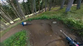
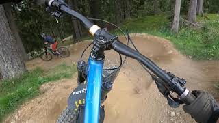
Abwechslungsreich und naturbelassen. Der Singletrail führt von der Bergstation über die Skipiste und durch den Wald zur Mittelstation der Muttereralmbahn.
Umfahrbare Sprünge und Anlieger machen den Trail besonders interessant für fortgeschrittene Rider, aber auch für erfahrene Tourenbiker, die sich für noch anspruchsvollere Trails fit machen wollen.

Charakteristik: Sprünge (umfahrbar), Wurzeln, Anlieger, Holzbauten
Characteristics: jums (can be circumnavigated), tree roots, berms, wooden elements
2,4 km // 350 Hm

Varied and natural. The single trail leads from the mountain station over the ski slope and through the forest to the middle station of the Muttereralm cable car.
Jumps and bends that can be ridden around make the trail particularly interesting for advanced riders, but also for experienced touring bikers who want to get fit for even more challenging trails.

Access Info

"The First One" - Bergstation / top station Muttereralmbahn

This trail is unsanctioned.

Disclaimer

Wearing a helmet is compulsory. Ride at your own risk.

Recent Activity on Trail

Past Week
  • 12 rides
  • 28 miles average
6 Months
  • 28 rides
  • 26 miles avg distance
All
  • 242 rides
  • Last: Jun 18, 2026
c1c2c3c4
January
February
March
April
May
June
July
August
September
October
November
December
update trails status or condition

The First One Trail Reports

statusdatedescription
Jun 17, 2026 @ 4:43pm (Europe/Vienna)
2 days
Second and third part of the First One are closed due to reshape/maintenance. First part, until the fire road, is in very good condition.
Mar 13, 2023 @ 9:55am
Mar 13, 2023
Some snow on the upper part, especially where out of the woods. After about 100 meters of descent it gets good.
Jul 26, 2022 @ 1:54am
Jul 26, 2022
Jul 2, 2022 @ 3:22am
Jul 2, 2022
Jul 1, 2022 @ 2:42am
Jul 1, 2022
more »
Status:
on Jun 17, 2026
Avg: 3.96 (23 votes)
Your vote: 0

view (3,014)
close
3D
Trail Conditions
  • Unknown
  • Snow Groomed
  • Snow Packed
  • Snow Covered
  • Snow Cover Partial
  • Freeze/thaw Cycle
  • Icy
  • Prevalent Mud
  • Wet
  • Variable
  • Ideal
  • Dry
  • Very Dry
Trail Flow (Ridden Direction)
Trailforks scans users ridelogs to determine the most popular direction each trail is ridden. A good flowing trail network will have most trails flowing in a single direction according to their intension.
The colour categories are based on what percentage of riders are riding a trail in its intended direction.
  • > 96%
  • > 90%
  • > 80%
  • > 70%
  • > 50%
  • < 50%
  • bi-directional trail
  • no data
Trail Last Ridden
Trailforks scans ridelogs to determine the last time a trail was ridden.
  • < 2 days
  • < 1 week
  • < 2 weeks
  • < 1 month
  • < 6 months
  • > 6 months
Trail Ridden Direction
The intended direction a trail should be ridden.
  • Downhill Only
  • Downhill Primary
  • Both Directions
  • Uphill Primary
  • Uphill Only
  • One Direction
Contribute Details
Colors indicate trail is missing specified detail.
  • Description
  • Photos
  • Description & Photos
  • Videos
Trail Popularity ?
Trailforks scans ridelogs to determine which trails are ridden the most in the last 9 months. Trails are compared with nearby trails in the same city region with a possible 25 colour shades. Think of this as a heatmap, more rides = more kinetic energy = warmer colors.
  • most popular
  • popular
  • less popular
  • not popular
ATV/ORV/OHV Filter
Max Vehicle Width
inches
US Cell Coverage
Legend
cell carrier legend

Radar Time
Activity Recordings
Trailforks uses anonymized public activity data. ?
Activity Recordings
Trailforks uses anonymized public activity data. ?
Personal Heatmap
Activity Types
all / none
Options
2
Date range month
Winter Trails
Warning A routing network for winter maps does not exist. Selecting trails using the winter trails layer has been disabled.
Missing Trails
Most Popular
Least Popular
Trails are colored based on popularity. The more popular a trail is, the more red. Less popular trails trend towards green.
Jump Magnitude Heatmap
Heatmap of where riders jump on trails. Zoom in to see individual jumps, click circles to view jump details.
BC Backroad Status

Service Road Atlas is a free to use, community-driven service for viewing and creating reports on the numerous back-country service roads around B.C. and Alberta.

map legend
Slope Aspect
Direction the slope faces
Flat N NE E SE S SW W NW
Trails Deemphasized
Trails are shown in grey.
disable
Only show trails with no bike usage.
Enable
Suggested Layers
Based on selected activity type

    Save the current map location and zoom level as your default home location whenever this page is loaded.

    Save
        Directions to the-first-one trailhead (47.211420, 11.333430)

        Photos

        23 more »
        36 |
        Aug 24, 2024 @ 8:58am
        Aug 24, 2024
        132 |
        Oct 2, 2018 @ 2:46am
        Oct 2, 2018
        123 |
        Oct 2, 2018 @ 2:46am
        Oct 2, 2018
        297 |
        Oct 2, 2018 @ 2:46am
        Oct 2, 2018

        Videos

        5 more »
        youtuber The First One -  Innsbruck Bike Park
        4:29 | 236 | Sep 20, 2023 , Innsbruck
        The First One - Bikepark Innsbruck
        6:07 | 78 | Sep 15, 2024 , Innsbruck
        Englishman'39s Near Death Nosedive at Bike...
        19:12 | 201 | Sep 10, 2022 , Innsbruck
        Bikepark Innsbruck Muttereralm FLOWTRAIL...
        1196 | Oct 12, 2017 , Innsbruck

        3 Reviews & Comments


        We hope you've been enjoying Trailforks!

        Create a FREE account to view trail comments and much more.

        • #54142 - 4,488 views

        Frequently Asked Questions About The First One

        Where is The First One located?
        The First One is located in Innsbruck, Austria. It is part of the Innsbruck trail network. The trailhead is located at coordinates 47.21142, 11.33343.
        How hard is The First One?
        The First One is rated as Red difficulty. The average grade is 13.9%.
        What is the elevation gain for The First One?
        The First One has 1 m of elevation gain. The trail has 263 m of elevation descent. The elevation ranges from 1,343 m to 1,605 m.
        Is The First One a point to point trail?
        Yes, The First One is a point to point trail. The direction is Downhill Only. The trail type is singletrack.

        Hit the Trail

        Open in App

        Get this trail on your phone instantly.
        open trail in app

        Download Trail

        Save to wishlist, Garmin & download.
        save the trail

        Find Related Routes

        Find routes and users activities that include this trail.
        find routes for this trail

        You must enter a description before submitting.